Maps of British Isles
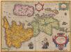
Britannicarum Insularum Typus. [Karte], in: Theatrum orbis terrarum, S. 365.
1 Karte aus Atlas Ortelius, Abraham
Insularum Britannicarum Acurata Delineatio [Karte], in: Gerardi Mercatoris et I. Hondii Newer Atlas, oder, Grosses Weltbuch, Bd. 1, S. 48.
1 Karte aus Atlas Mercator, Gerhard und Hondius, Jodocus Jansson, Jan
Charte der vereinigten Königreiche Grosbritanien und Ireland
1 Karte : Kupferdruck ; 59 x 47 cm Weidner im Verlage des Industrie Comptoirs
Grossbritannien und Irland
1 Karte : Kupferdruck ; 29 x 25 cm Sotzmann; Jättnig s.n.
A compleat map of the British Isles or Great Britain and Ireland
1 Karte : Kupferdruck ; 59 x 46 cm Sayer publish'd by Rob.t Sayer no. 53 Fleet Street as the act directs
Carte réduite des isles Britanniques
1 Karte : Kupferdruck ; 85 x 53 cm Bellin; Haussard s.n.
Petit neptune anglois ou carte marine des côtes d'Angleterre, d'Ecosse et d'Irlande
1 Karte : Kupferdruck ; 66 x 51 cm Bonne; Lattré; Marillier; Berthault chez Lattré graveur rue St. Jacques près la fontaine St. Severin à la ville de Bordeaux
Tableau l'historie des Iles Britanniques.
1 : 8200000 Duval, Henri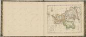

Carte Physique et Mineralogique des Isles Britanniques
1 : 15000000 Malte-Brun, Conrad, 1775-1826
Great Britain and Ireland. Pergamon World Atlas.
1 : 2500000 Polish Army Topography Service
Soubor němých map pro gymnasia a odborné školy

Atlas orbis antiqui totius secundum optimos scriptores ...

Insularum Britannicarum acurata delineatio ex geographicis conatibus Abrahami Ortelii
1 : 2500000 Petrus Kaerius caelavit Amstelodami : apud Joannem Janssonium
[Grossbritannien; England, Scotland und Ireland]
Geographischer Atlas über alle Theile der Erde Ziegler, Jakob Melchior Verlag von Dietrich Reimer
Britischen Inseln.
1 : 1800000 Kiepert, Heinrich, 1818-1899
Composite: Geological, palaeontological map British Islands.
1 : 1550000 Johnston, Alexander Keith, 1804-1871
British Islands.
1 : 5500000 Fitch, George W.
Gt. Britain, Ireland.
1 : 4800000 Mitchell, Samuel Augustus
Iles Britanniques.
1 : 2500000 Andriveau-Goujon, J.
British Isles.
1 : 5000000 Adams, Daniel
Insvlæ britannicæ antiqvæ
1 Karte : Kupferdruck ; 31 x 38 cm Weigel Christoph Weigel
Her most excellent majesty queen Victoria this Hydrolographical map of the British Isles
1 : 1600000 Velká Británie Petermann, August Symons, G. J. Edward Stanford
Insularum Britannicarum Acurata Delineatio ex Geographicis Conatibus Abrahami Ortelii [Karte], in: Novus atlas absolutissimus, Bd. 7, S. 14.
1 Karte aus Atlas Janssonius Offizin
Composite: Carte des Iles Britanniques.
1 : 2600000 Vivien de St Martin, L.
Grossbritannien u. Irland.
1 : 2500000 Stein, Christ. Gottfr. Dan.
Iles Britanniques.
1 : 2950000 Montemont, A.
[Grossbritannien; England, Scotland und Ireland]
Geographischer Atlas über alle Theile der Erde Ziegler, Jakob Melchior Verlag von Joh. Wurster um Comp.
![Britannicarum Insularum Typus. [Karte], in: Theatrum orbis terrarum, S. 365.](https://images-2.georeferencer.com/images/iiif/835676677034/full/,300/0/native.jpg)

