Maps of British Isles

Grossbritannien u. Irland.
1 : 2500000 Stein, Christ. Gottfr. Dan.
Géographie. croquis n12, Iles britanniques
1 : 2000000 Lambin, Capitaine 18..-.... [Paris] : Service Géographique de l'Armée
Charte der vereinigten Königreiche Grosbritanien und Ireland
1 Karte : Kupferdruck ; 59 x 47 cm Weidner im Verlage des Industrie Comptoirs
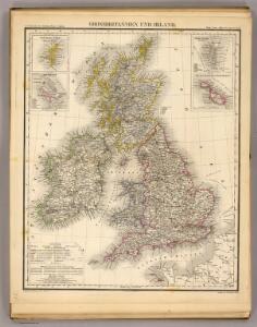
Grossbritannien und Irland
1 Karte : Kupferdruck ; 29 x 25 cm Sotzmann; Jättnig s.n.
A compleat map of the British Isles or Great Britain and Ireland
1 Karte : Kupferdruck ; 59 x 46 cm Sayer publish'd by Rob.t Sayer no. 53 Fleet Street as the act directs
Carte réduite des isles Britanniques
1 Karte : Kupferdruck ; 85 x 53 cm Bellin; Haussard s.n.
Petit neptune anglois ou carte marine des côtes d'Angleterre, d'Ecosse et d'Irlande
1 Karte : Kupferdruck ; 66 x 51 cm Bonne; Lattré; Marillier; Berthault chez Lattré graveur rue St. Jacques près la fontaine St. Severin à la ville de Bordeaux
Atlas orbis antiqui totius secundum optimos scriptores ...

Ethnographic, Gt. Brit., Ireland.
1 : 1850000 Kombst, Gustaf
Britain.
1 : 4500000 Cummings, J. A. (Jacob Abbot)
British Isles.
1 : 1680000 Pinkerton, John, 1758-1826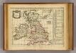
Angleterre, Ecosse, Irelande.
1 : 6000000 Delamarche, Charles Francois; Lattre, Jean
Carte générale des isles britanniques
1 Karte : Kupferdruck ; 76 x 51 cm Hérisson; Perrier; Basset; Basset chez Basset rue St. Jacques no. 670
General=Karte von Grossbritannien und Ireland
1 Karte : Kupferdruck ; 27 x 23 cm Reilly F. J. J. von Reilly
Mappa insularum Britannicarum antiquarum
1 Karte : Kupferdruck ; 32 x 21 cm Bonne; Perrier; André s.n.
Carte des royaumes d'Angleterre, d'Ecosse et d'Irlande
1 Karte : Kupferdruck ; 31 x 21 cm Bonne; Perrier s.n.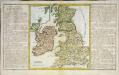
Des isles Britanniques
1 Karte : Kupferdruck ; 31 x 29 cm, Bildgrösse 32 x 55 cm Clouet Mondhare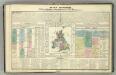
Tableau l'historie des Iles Britanniques.
1 : 8200000 Duval, Henri

Grossbritannien, Ireland.
1 : 3900000 Radefeld, Carl Christian Franz, 1788-1874
Iles Britanniques.
1 : 2950000 Montemont, A.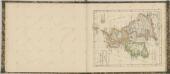

Great Britain and Ireland. Pergamon World Atlas.
1 : 2500000 Polish Army Topography Service
Carte Physique et Mineralogique des Isles Britanniques
1 : 15000000 Malte-Brun, Conrad, 1775-1826
Map of the British Isles
1 : 908500 Shetlandy (Skotsko) Cary, John
Britischen Inseln.
1 : 1800000 Kiepert, Heinrich, 1818-1899
Composite: Geological, palaeontological map British Islands.
1 : 1550000 Johnston, Alexander Keith, 1804-1871
British Islands.
1 : 5500000 Fitch, George W.
Gt. Britain, Ireland.
1 : 4800000 Mitchell, Samuel Augustus
Iles Britanniques.
1 : 2500000 Andriveau-Goujon, J.
British Isles.
1 : 5000000 Adams, Daniel