Maps of British Isles

Novissima prae caeteris aliis accuratissima regnorum Angliae, Scotiae, Hiberniae tabula
1 : 1900000 auctore Petri Schenk Amstelodami : Petrus Schenk
Britische Inseln
Neuer Handatlas über alle Theile der Erde Kiepert, Heinrich Verlag von Dietrich Reimer
United Kingdom.
1 : 4100000 Darton, William
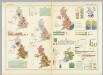
[Ethnographic Map of Great Britain and Ireland]
The physical atlas Johnston, Alexander Keith William Blackwood & Sons
Philips Railway map of the British Isles


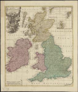
TABULA NOVISSIMA ACCURATISSIMA REGNORUM ANGLIAE, SCOTIAE HIBERNIAE
1 : 1900000 Anglie Seutter, Matthäus Mattheo Seutter
Tabula novissima accuratissima regnorum Angliae, Scotiae Hiberniae
1 : 1900000 Irsko Seutter, Matthäus M. Seutter
Die Britischen Inseln oder die Vereinigten Königreiche
1 : 1850000 Normanské ostrovy Kiepert, Heinrich Gräf, C. Geographisches Institut
[Neuer Atlas der ganzen Erde nach den neuesten Bestimmungen ... : XI.] Die Britischen Inseln
Entworfen und gezeichnet von Dr. F.W. Streit H. Leutemann sc. Leipzig : J.C. Hinrichs'sche Buchhandlung
British Isles.
1 : 2661120 Letts, Son & Co.
Railway Map of the British Isles.
1 : 2217600 Fullarton, A. & Co.
The British Isles.
1 : 2700000 Society for the Diffusion of Useful Knowledge (Great Britain)
British Islands.
1 : 3484800 Burr, David H., 1803-1875
British Isles, Asia.
Adams, Daniel
British Isles.
1 : 1700000 Thomson, John
British Isles.
1 : 2728000 Gray, Ormando Willis
Hydrographical map, British Isles.
1 : 1600000 Stanford, Edward
Welká Britanie a Iry

British Isles - railways & industrial.
1 : 2000000 John Bartholomew & Co.
British Isles - bathy-orographical.
1 : 2000000 John Bartholomew & Co.
British Isles - political.
1 : 2000000 John Bartholomew & Co.
Großbritannien und Irland
1 : 1000000 Irsko Velhagen & Klasing
British Islands.
1 : 4000000 Schonberg & Co.
British Isles (Political).
1 : 1900000 Johnston, W. & A.K.
Iles Britanniques.
1 : 2500000 Brue, Adrien Hubert, 1786-1832
Les Britannique.
1 : 2850000 Migeon, J.
British Islands.
1 : 2300000 Morse, Jedidiah; Morse, Sidney E. (Sidney Edwards), 1794-1871
Geographische Carte von Gross-Britannien zum Gebrauch beim Studium der Geschichte
Historisch-genealogisch-geographischer Atlas von Le Sage Las Cases, Emmanuel Auguste Dieudonné Marius Joseph de Johann Velten, Kunsthändler