Maps of British Isles
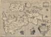
Britannicarum Insularum Typus. [Karte], in: Theatrum orbis terrarum, S. 456.
1 Karte aus Atlas Ortelius, Abraham Vrients, Jan Baptista
Insularum Britannicarum Acurata Delineatio ex Geographicis Conatibus Abrahami Ortelii [Karte], in: Novus atlas absolutissimus, Bd. 7, S. 14.
1 Karte aus Atlas Janssonius Offizin
Insularum Britannicarum acurata delineatio ex geographicis conatibus Abrahami Ortelii
1 : 2500000 Petrus Kaerius caelavit Amstelodami : apud Joannem Janssonium
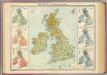
Geological map, British Isles.
1 : 1600000 Stanford, Edward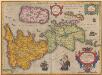
Britannicarum Insularum Typus. [Karte], in: Theatrum orbis terrarum, S. 365.
1 Karte aus Atlas Ortelius, Abraham
Insularum Britannicarum Acurata Delineatio [Karte], in: Gerardi Mercatoris et I. Hondii Newer Atlas, oder, Grosses Weltbuch, Bd. 1, S. 48.
1 Karte aus Atlas Mercator, Gerhard und Hondius, Jodocus Jansson, Jan
British Isles. Pergamon World Atlas.
Polish Army Topography Service
Her most excellent majesty queen Victoria this Hydrolographical map of the British Isles
1 : 1600000 Velká Británie Petermann, August Symons, G. J. Edward Stanford
Britannicarum insularum typus / ex conatibus geographicis Abrah. Ortelius
1 : 2500000 Annotatie: Oorspr. verschenen in: Theatrum Orbis Terrarum opus nunc denuo ... - [Antwerpen : Abraham Ortelius]; Origineel is Blad 24 in atlas factice; Annotatie geografische gegevens: West boven Ortelius, Abraham [Antwerpen : Arbraham Ortelius]
Grande Bretagne, Irlande 1400 a 1603.
1 : 4500000 Houze, Antoine Philippe
British Isles.
1 : 2250000 Hall, S. (Sidney)
Atlas orbis antiqui totius secundum optimos scriptores ...
British Isles - vegetation & climate.
1 : 3000000 John Bartholomew & Co.
Bretagne Anglo Saxonne, 600 ans apres Jesus Christ.
1 : 4500000 Houze, Antoine Philippe
Isles Britanniques
1 : 3770000 Anglie Bonne, Rigobert André
Bretagne Romaine sous Honorius, 400 ans apres Jesus Christ.
1 : 4500000 Houze, Antoine Philippe
Angleterre, Ecosse & Irlande en 900.
1 : 4500000 Houze, Antoine Philippe
Grossbritannien u. Irland.
1 : 2500000 Stein, Christ. Gottfr. Dan.
Industrial map of the British Islands
1 : 1200000 Shetlandy (Skotsko) Hughes, W. George Philip & Son
Comparative Size of Lakes and Islands.
Colton, G. Woolworth
Grossbritannien und Ireland
1 : 2200000 Irsko Weiland, Karl Ferdinand Maedel, Carl Jos. Geograph. Institut
Angleterre, Ecosse, Irlande et Man en 1100.
1 : 4500000 Houze, Antoine Philippe
Philips' Railway Map of the British Isles
1 : 1087000 Edinburgh (Skotsko) George Philip & Son
Géographie. croquis n12, Iles britanniques
1 : 2000000 Lambin, Capitaine 18..-.... [Paris] : Service Géographique de l'Armée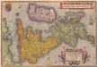
Angliae, Scotiae, Et Hiberniae, Sive Britannicarum Insularum Descriptio. [Karte] , in: Theatrum orbis terrarum, S. 30.
1 Karte aus Atlas Ortelius, Abraham
Insulae Britannicae
1 : 3760000 Velká Británie Bonne, Rigobert André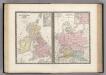
Iles Britanniques et Germanie Anciennes.
Levasseur, E.
Britannia et Hibernia.
1 : 3000000 Strabo
Bretagne Anglo Saxonne, 800 ans apres J.C.
1 : 4500000 Houze, Antoine Philippe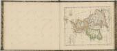
![Britannicarum Insularum Typus. [Karte], in: Theatrum orbis terrarum, S. 456.](https://images-2.georeferencer.com/images/iiif/174464923878/full/,300/0/native.jpg)

