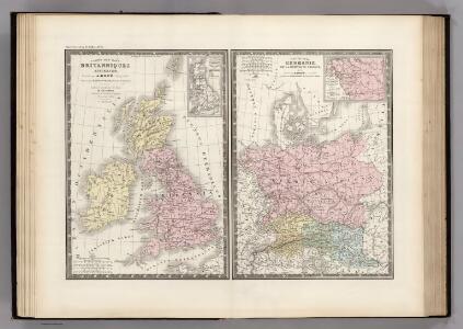
Maps of British Isles
Iles Britanniques et Germanie Anciennes.
Levasseur, E.
Bretagne Anglo Saxonne, 800 ans apres J.C.
1 : 4500000 Houze, Antoine Philippe
Parliamentary map, British Isles.
1 : 1774080 Stanford, Edward
Angleterre, Irelande & Ecosse 1281 a 1400.
1 : 4500000 Houze, Antoine Philippe
Bretagne apres l'invasion des Saxons, 500 ans apres Jesus Christ.
1 : 4500000 Houze, Antoine Philippe
Bretagne Anglo Saxonne, 600 ans apres Jesus Christ.
1 : 4500000 Houze, Antoine Philippe
Grossbritannien.
1 : 24000000 Ziegler, J. M.
Angleterre, Ecosse, Irlande et Man 1100 a 1280.
1 : 4500000 Houze, Antoine Philippe

Royaume Uni, Angleterre, Ecosse, et Irlande 1603 a 1839.
1 : 4500000 Houze, Antoine Philippe
Grossbritannien und Ireland

Railway map, British Isles.
1 : 1774080 Stanford, Edward
Isles Britanniques
1 : 3770000 Anglie Bonne, Rigobert André
Angleterre, Ecosse, Irlande et Man en 1100.
1 : 4500000 Houze, Antoine Philippe
Iles Britanniques ancienne, Germanie, de la Rhetie, du Norique, etc.
1 : 3800000 Picquet, C.
Britannia et Hibernia.
1 : 3000000 Strabo
Grossbritannien und Ireland
1 : 2200000 Irsko Weiland, Karl Ferdinand Maedel, Carl Jos. Geograph. Institut
Grossbritanien und Irland
Irsko Sotzmann, Daniel Friedrich Kliewer, Heinrich
Geological map, British Isles.
1 : 1600000 Stanford, Edward
Bretagne Romaine sous Honorius, 400 ans apres Jesus Christ.
1 : 4500000 Houze, Antoine Philippe
Comparative Size of Lakes and Islands.
Colton, G. Woolworth
Industrial map of the British Islands
1 : 1200000 Shetlandy (Skotsko) Hughes, W. George Philip & Son
Grande Bretagne, Irlande 1400 a 1603.
1 : 4500000 Houze, Antoine Philippe
Soubor němých map pro gymnasia a odborné školy

Angleterre, Ecosse & Irlande en 900.
1 : 4500000 Houze, Antoine Philippe

Composite: Carte des Iles Britanniques.
1 : 2600000 Vivien de St Martin, L.
Great Britain and Ireland. .
1 : 3380000 Sharpe, J.
Grossbritannien u. Irland.
1 : 2500000 Stein, Christ. Gottfr. Dan.