Maps of British Isles

Bretagne Romaine sous Honorius, 400 ans apres Jesus Christ.
1 : 4500000 Houze, Antoine Philippe
Angleterre, Ecosse, Irlande et Man en 1100.
1 : 4500000 Houze, Antoine Philippe
Industrial map of the British Islands
1 : 1200000 Shetlandy (Skotsko) Hughes, W. George Philip & Son
Comparative Size of Lakes and Islands.
Colton, G. Woolworth
Grossbritannien und Ireland
1 : 2200000 Irsko Weiland, Karl Ferdinand Maedel, Carl Jos. Geograph. Institut
Bretagne Anglo Saxonne, 600 ans apres Jesus Christ.
1 : 4500000 Houze, Antoine Philippe
Philips' Railway Map of the British Isles
1 : 1087000 Edinburgh (Skotsko) George Philip & Son
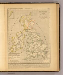
Royaume Uni, Angleterre, Ecosse, et Irlande 1603 a 1839.
1 : 4500000 Houze, Antoine Philippe
Grossbritanien und Irland
Irsko Sotzmann, Daniel Friedrich Kliewer, Heinrich
Britannia et Hibernia.
1 : 3000000 Strabo
Isles Britanniques
1 : 3770000 Anglie Bonne, Rigobert André
Great Britain and Ireland. .
1 : 3380000 Sharpe, J.
Angleterre, Irelande & Ecosse 1281 a 1400.
1 : 4500000 Houze, Antoine Philippe
Angleterre, Ecosse & Irlande en 900.
1 : 4500000 Houze, Antoine Philippe
British Isles. Pergamon World Atlas.
Polish Army Topography Service
Grande Bretagne, Irlande 1400 a 1603.
1 : 4500000 Houze, Antoine Philippe
Iles Britanniques et Germanie Anciennes.
Levasseur, E.
Petit Neptune anglois ou carte marine des côtes d'Angleterre, d'Ecosse et d'Irlande
1 Karte : Kupferdruck ; 65 x 50 cm Bonne; Lattré; Marillier; Berthault chez Lattré graveur rue St. Jacques près la fontaine St. Severin à la ville de Bordeaux
Bretagne apres l'invasion des Saxons, 500 ans apres Jesus Christ.
1 : 4500000 Houze, Antoine Philippe
Ethnographic, Gt. Brit., Ireland.
1 : 1850000 Kombst, Gustaf
Britain.
1 : 4500000 Cummings, J. A. (Jacob Abbot)
British Isles.
1 : 1680000 Pinkerton, John, 1758-1826
Angleterre, Ecosse, Irelande.
1 : 6000000 Delamarche, Charles Francois; Lattre, Jean
Carte générale des isles britanniques
1 Karte : Kupferdruck ; 76 x 51 cm Hérisson; Perrier; Basset; Basset chez Basset rue St. Jacques no. 670
General=Karte von Grossbritannien und Ireland
1 Karte : Kupferdruck ; 27 x 23 cm Reilly F. J. J. von Reilly
Mappa insularum Britannicarum antiquarum
1 Karte : Kupferdruck ; 32 x 21 cm Bonne; Perrier; André s.n.
Carte des royaumes d'Angleterre, d'Ecosse et d'Irlande
1 Karte : Kupferdruck ; 31 x 21 cm Bonne; Perrier s.n.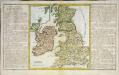
Des isles Britanniques
1 Karte : Kupferdruck ; 31 x 29 cm, Bildgrösse 32 x 55 cm Clouet Mondhare
Géographie. croquis n12, Iles britanniques
1 : 2000000 Lambin, Capitaine 18..-.... [Paris] : Service Géographique de l'Armée