Maps of Netherlands

Niederlande, Belgien.
1 : 800000 Kiepert, Heinrich, 1818-1899
Carte de l'Angleterre avec les divisions Saxonnes
Anglie Raffelsperger, Franz Kitchin, Thomas

Belgique, Hollande.
1 : 1000000 Lapie, M. (Pierre), 1779-1850

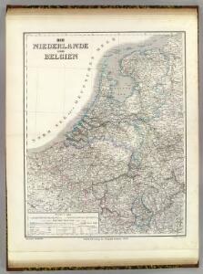
Niederlande und Belgien
E. von Sydow's Schul-Atlas in sechs und dreissig Karten Sydow, Emil von bei Justus Perthes
The Kingdom of the Netherlands
1 : 1495000 Belgie Walker, C. Baldwin & Gradock
XVII PROVINCIAE BELGII accurate delineatae
Belgie
Nieuwe kaart van het Koningrijk der Nederlanden en het Groot-Hertogdom Luxemburg : met aanwijzing der nieuwe postwegen = Nouvelle carte du Royaume des Pays-Bas et du Grand-Duché de Luxembourg : avec les routes de poste / dressé et gravé par C. van Baarsel et Fils
1 : 580000 Baarsel, C. van La Haye : F.J. Weygand
Niederlande, Luxemburg.
1 : 1900000 Reichard, C. G.
Pays-Bas.
1 : 1000000 Brue, Adrien Hubert, 1786-1832
Hollande, Belgique.
1 : 1070000 Andriveau-Goujon, J.
Niederlande, Belgien.
1 : 1470000 Flemming, Carl
[Historisch-geographischer Atlas zu den allgemeinen Geschichtswerken von C. v. Rotteck, Pölitz u. Becker] : Die Niederlande zur Uebersicht der Hauptbegebenheiten
von Julius Loewenberg Lithographie von B. Herder zu Freiburg im Breisgau [Freiburg im Breisgau] : [Herder]
Niederlande und Belgien
Plastischer Schul-Atlas über alle Theile der Erde : in 24 Karten Woldermann, G Verlag von P. Eckerlein
Holland And Belgium.
1 : 1900800 Mitchell, Samuel Augustus
Belgium And Holland.
1 : 1520640 Burr, David H., 1803-1875
Netherlands.
1 : 3350000 Fenner, Rest.
Netherlands, Belgium, Spain, Portugal.
Goodrich, S.G.
Netherlands.
1 : 1480000 Society for the Diffusion of Useful Knowledge (Great Britain)
Das Königreich der Niederlande, das Königreich Belgien und das Groszherzogthum Luxemburg
1 : 950000 entworfen und gezeichnet von C.F. Weiland. Weimar : im Verlage des Geogr. Instituts
Holland and Belgium.
1 : 1290000 Colton, G.W.

Das Königreich der Niederlande. Das Königreich Belgien und das Grossherzogthum Luxemburg


Niederlande und Belgien
Volksschul-Atlas über alle Teile der Erde Lange, Henry Druck und Verlag von Georg Westermann
Holland & Belgium.
1 : 950400 Fullarton, A. & Co.
Belgique et Hollande
1 : 1300000 Thuillier, Louis; Hachette. Bibliothèque géographique. Firme Paris : Hachette et cie.
Neueste Karte von Holland, Belgien und Luxemburg
Grosser Hand-Atlas über alle Theile der Erde in 170 Karten Meyer, J. Verlag des Bibliographischen Instituts