Maps of Netherlands

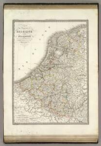
Belgique, Hollande.
1 : 1000000 Lapie, M. (Pierre), 1779-1850
Niederlande und Belgien
E. von Sydow's Schul-Atlas in sechs und dreissig Karten Sydow, Emil von bei Justus Perthes
Niederlande und Belgien
Adolf Stieler's Handatlas über alle Theile der Erde und über das Weltgebäude Stieler, Adolf Justus Perthes
Das Königreich Niederlande, das Königreich Belgien, und das Grossherzogthum Luxemburg
1 : 925000 Belgie Schmitfeldt, Georg Mollo, Tranquillo Tranquillo Mollo
Novus XVII Inferioris Germaniae Procinviarum Typus [Karte], in: Theatrum orbis terrarum, sive, Atlas novus, Bd. 1, S. 323.
1 Karte aus Atlas Blaeu, Joan Blaeu, Willem Janszoon
NOVUS XVII | INFERIORIS GERMANIÆ | PROVINCIARUM TYPUS
de integro multis in locis emendatus à Guliel. Ianßonio. Josua | vanden Ende sculp. Ghedruckt | t'Amsterdam, | bij Willem Ianszoon op 't Water | inde vergulde Zonnewyser
NOVUS XVII | INFERIORIS GERMANIÆ | PROVINCIARUM TYPUS
de integro multis in locis emendatus à Guliel. Ianßonio. Josua | vanden Ende sculp. Ghedruckt | t'Amsterdam, | bij Willem Ianszoon op 't Water | inde vergulde Zonnewyser
Holland And Belgium.
1 : 1900800 Mitchell, Samuel Augustus
Belgium And Holland.
1 : 1520640 Burr, David H., 1803-1875
Netherlands.
1 : 3350000 Fenner, Rest.
Netherlands, Belgium, Spain, Portugal.
Goodrich, S.G.
Netherlands.
1 : 1480000 Society for the Diffusion of Useful Knowledge (Great Britain)

Hollande, Belgique.
1 : 1070000 Andriveau-Goujon, J.

Niederlande, Luxemburg.
1 : 1900000 Reichard, C. G.
Novus XVII Inferioris Germaniae Provinciarum Typus [...] [Karte], in: Novus Atlas, das ist, Weltbeschreibung, Bd. 1, S. 298.
1 Karte aus Atlas Blaeu, Joan Blaeu, Willem Janszoon
Novus XVII Inferioris Germaniae Provinciarum Typus [Karte], in: Le théâtre du monde, ou, Nouvel atlas contenant les chartes et descriptions de tous les païs de la terre, Bd. 1, S. 329.
1 Karte aus Atlas Blaeu, Willem Janszoon und Blaeu, Joan Blaeu, Willem Janszoon
Novissima et accuratissima XVII Provinciarum Germaniae Inferioris Delineatio. [Karte], in: Novus atlas absolutissimus, Bd. 3, S. 22.
1 Karte aus Atlas Janssonius Offizin
Belgii sive Germaniae Inferioris accuratissima tabula. [Karte], in: Gerardi Mercatoris et I. Hondii Newer Atlas, oder, Grosses Weltbuch, Bd. 1, S. 368.
1 Karte aus Atlas Mercator, Gerhard und Hondius, Jodocus Jansson, Jan
Carte des XVII. Provinces des Pays Bas
1 : 640000 Mollova mapová sbírka Inselin, Charles Jaillot, Alexis Hubert
Nieuwe kaart van het Koningrijk der Nederlanden en het Groot-Hertogdom Luxemburg : met aanwijzing der nieuwe postwegen = Nouvelle carte du Royaume des Pays-Bas et du Grand-Duché de Luxembourg : avec les routes de poste / dressé et gravé par C. van Baarsel et Fils
1 : 580000 Baarsel, C. van La Haye : F.J. Weygand
Die Niederlande und Belgien
1 : 830000 Belgie Kiepert, Heinrich Eulenstein, F. Geographisches Institut
XVII PROVINCIAE BELGII accurate delineatae
Belgie
Nova Totius Belgii Sive Germaniae Inferioris accuratissima Delineatio. [Karte], in: Novus atlas absolutissimus, Bd. 3, S. 11.
1 Karte aus Atlas Janssonius Offizin
[Historisch-geographischer Atlas zu den allgemeinen Geschichtswerken von C. v. Rotteck, Pölitz u. Becker] : Die Niederlande zur Uebersicht der Hauptbegebenheiten
von Julius Loewenberg Lithographie von B. Herder zu Freiburg im Breisgau [Freiburg im Breisgau] : [Herder]

Les Pays Bas.
1 : 2150000 Lattre, Jean
Mare Germanicum ab Amelandia ad promontoria Caleti et Doveræ
1 Karte : Kupferdruck ; 47 x 57 cm Renard by L. Renard