Maps of Netherlands


Das Königreich Niederlande, das Königreich Belgien, und das Grossherzogthum Luxemburg
1 : 925000 Belgie Schmitfeldt, Georg Mollo, Tranquillo Tranquillo Mollo
Holland And Belgium.
1 : 1900800 Mitchell, Samuel Augustus
Belgium And Holland.
1 : 1520640 Burr, David H., 1803-1875
Netherlands.
1 : 3350000 Fenner, Rest.
Netherlands, Belgium, Spain, Portugal.
Goodrich, S.G.
Netherlands.
1 : 1480000 Society for the Diffusion of Useful Knowledge (Great Britain)
Carte du Royaume des Pays-Bas, comprenant les routes de poste et relais depuis Paris jusqu'aux frontières septentrionales de la Hollande, avec un Itinéraire des communications de Strasbourg à Amsterdam et Hambourg
1 : 1280000 [par] Hocquart. Paris : Audin
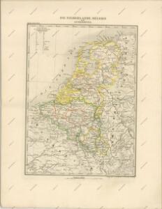
Niederlande und Belgien
Adolf Stieler's Handatlas über alle Theile der Erde und über das Weltgebäude Stieler, Adolf Justus Perthes
Holland and Belgium.
1 : 2080000 Tanner, Henry S.
Niederland und Belgien
Geographischer Atlas über alle Theile der Erde Ziegler, Jakob Melchior Verlag von Joh. Wurster um Comp.
[Historisch-geographischer Atlas zu den allgemeinen Geschichtswerken von C. v. Rotteck, Pölitz u. Becker] : Die Niederlande zur Uebersicht der Hauptbegebenheiten
von Julius Loewenberg Lithographie von B. Herder zu Freiburg im Breisgau [Freiburg im Breisgau] : [Herder]
Niederlande und Belgien
E. von Sydow's Schul-Atlas in sechs und dreissig Karten Sydow, Emil von bei Justus Perthes
Niederlande u. Belgien.
1 : 1050000 Stein, Christ. Gottfr. Dan.
Niederlande u. Belgien
[Allgemeiner Atlas über alle Theile der Erde in 29 Blättern] Ziegler, Jakob Melchior Top. Anstalt v. J. Wurster u. Comp.
Niederlande und Belgien
Geographischer Atlas über alle Theile der Erde Ziegler, Jakob Melchior Verlag von Dietrich Reimer
Inferioris Germaniae provinciarum nova descriptio / [Willem Jansz. Blaeu]
1 : 900000 Annotatie: Onder de titel een nadere omschrijving in het Latijn en Nederlands; Aan het oorspronkelijke kaartbeeld zijn het Bourtangerveen en Fort Bourtange toegevoegd; Lit.: Monumenta cartografica Neerlandica, IV, p. 31-32, 146-153, facs. 5; Oorspr. uitg.: 1604 Blaeu, Willem Jansz. Amstelodami : ex officina Guilielmi Johannis
Die Niederlande und Belgien
1 : 830000 Belgie Kiepert, Heinrich Eulenstein, F. Geographisches Institut
Niederlande und Belgien
Neuer Handatlas über alle Theile der Erde Kiepert, Heinrich Verlag von Dietrich Reimer
Carte routière du Royaume des Pays-Bas, comprenant la Hollande et la Belgique, aux quelles on a joint le grand Duché de Luxembourg : avec l'indication des archevêchés et evêcheés, ainsi que les batailles et les distances d'un lieu à un autre en lieues de poste de 281⁄2 au degré
1 : 650000 par Hérisson, géographe gravé par Berthe. Paris : Basset
NOVUS XVII | INFERIORIS GERMANIÆ | PROVINCIARUM TYPUS
de integro multis in locis emendatus à Guliel. Ianßonio. Josua | vanden Ende sculp. Ghedruckt | t'Amsterdam, | bij Willem Ianszoon op 't Water | inde vergulde Zonnewyser
Novus XVII Inferioris Germaniae Procinviarum Typus [Karte], in: Theatrum orbis terrarum, sive, Atlas novus, Bd. 1, S. 323.
1 Karte aus Atlas Blaeu, Joan Blaeu, Willem Janszoon
Belgique, Hollande.
1 : 1000000 Lapie, M. (Pierre), 1779-1850
Novus XVII Inferioris Germaniae Provinciarum Typus [Karte], in: Le théâtre du monde, ou, Nouvel atlas contenant les chartes et descriptions de tous les païs de la terre, Bd. 1, S. 329.
1 Karte aus Atlas Blaeu, Willem Janszoon und Blaeu, Joan Blaeu, Willem Janszoon
NOVUS XVII | INFERIORIS GERMANIÆ | PROVINCIARUM TYPUS
de integro multis in locis emendatus à Guliel. Ianßonio. Josua | vanden Ende sculp. Ghedruckt | t'Amsterdam, | bij Willem Ianszoon op 't Water | inde vergulde Zonnewyser
Belgii sive Germaniae Inferioris accuratissima tabula. [Karte], in: Gerardi Mercatoris et I. Hondii Newer Atlas, oder, Grosses Weltbuch, Bd. 1, S. 368.
1 Karte aus Atlas Mercator, Gerhard und Hondius, Jodocus Jansson, Jan
Nova Totius Belgii Sive Germaniae Inferioris accuratissima Delineatio. [Karte], in: Novus atlas absolutissimus, Bd. 3, S. 11.
1 Karte aus Atlas Janssonius Offizin
Holland And Belgium.
1 : 2100000 Tanner, Henry S.
Holland And Belgium.
1 : 2050000 Tanner, Henry S.