Maps of Netherlands

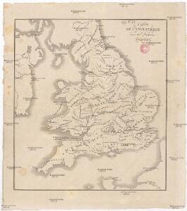
Carte de l'Angleterre avec les divisions Saxonnes
Anglie Raffelsperger, Franz Kitchin, Thomas
Niederlande, Belgien.
1 : 800000 Kiepert, Heinrich, 1818-1899
England & Wales
Anglie Wyld, James Kitchin, Thomas James Wyld
Britanniae sive Angliae regnum
Anglie Seutter, Matthäus Vilém Oranžský sumtibus Matthaei Seutteri
Magnae Britanniae pars meridionalis, in qua regnum Angliae tam in septem antiqua Anglo-saxonum regna quam in omnes hodiernas regiones accurate divisum hic ostenditur
Anglie Homann, Johann Baptist Visscher, Nicolaes Jansz. Ioh. Bapt. Homan[n
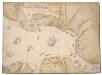
The North Sea with Vignette view of Towns, with London seen as if from the Thames
This is a map showing the North Sea from North Holland (Zuidersee) to Boulogne and Dover to Tynemouth. It dates from September October 1539 and is likely to have been drawn by the cartographer John Borough with decorative ships drawn by the King’s painter Anthony Anthony. John Borough was a sea man who possessed a wealth of knowledge on navigation. He was occasionally employed to sail along the Flemish coast to look for enemy ships. By 25th of October Henry VIII was reported as ordering the Calais authorities to prepare for Anne of Cleves who would journey to England via the English outpost. It is possible that this map could be the presentation copy for the Cleves envoys, illustrating how Anne of Cleves could be safely transported from north Holland to England. Vignette views of towns feature, with London seen from the Thames, where Anne would be deposited. The small ships that are drawn in the Zee and the large English ships with Royal standard outside, support this idea as they illustrate how Anne could be transferred from different sailing vessels. A squadron is shown blocking the channel from Dunkirk to Dover making possible a landing for Anne at the mouth of the Thames. The scale of the map is varied, with Zuidersee being drawn at a larger scale than elsewhere. [Borough, John a]
Nieuwe kaart van het Koningrijk der Nederlanden en het Groot-Hertogdom Luxemburg : met aanwijzing der nieuwe postwegen = Nouvelle carte du Royaume des Pays-Bas et du Grand-Duché de Luxembourg : avec les routes de poste / dressé et gravé par C. van Baarsel et Fils
1 : 580000 Baarsel, C. van La Haye : F.J. Weygand
Carte physique et routière du royaume des Pays-Bas indiquant les canaux de différentes classes, les relais de poste et leurs distances intermediaires
1 : 600000 par J. Andriveau géographe gravé au burin par Piat ; la lettre par Arnoul. Paris : chez J. Goujon & J. Andriveau ...
[Kaart], uit: Orandakoku zenzu / Senseki Takami
1 : 600000 Annotatie: Facs. van de uitg.: Furukawa : Kakindō, 1850; Lit.: The world in Japanese maps until the mid-19th century, p. 207; Annotatie geografische gegevens: West boven Takami, Senseki [Tokyo : Noma Kakagu Igaku Kenyu Shiryokan]
Belgique et Hollande
1 : 1300000 Thuillier, Louis; Hachette. Bibliothèque géographique. Firme Paris : Hachette et cie.
The Kingdom of the Netherlands
1 : 1495000 Belgie Walker, C. Baldwin & Gradock
Regni di Olanda e del Belgio, e Gran Ducato di Luembourg.
1 : 1010000 Marzolla, Benedetto

[Historisch-geographischer Atlas zu den allgemeinen Geschichtswerken von C. v. Rotteck, Pölitz u. Becker] : Die Niederlande zur Uebersicht der Hauptbegebenheiten
von Julius Loewenberg Lithographie von B. Herder zu Freiburg im Breisgau [Freiburg im Breisgau] : [Herder]
Niederlande, Belgien.
1 : 1470000 Flemming, Carl
Holland and Belgium.
1 : 1300000 Colton, G.W.
Niederlande und Belgien
E. von Sydow's Schul-Atlas in sechs und dreissig Karten Sydow, Emil von bei Justus Perthes
Pays-Bas.
1 : 1000000 Brue, Adrien Hubert, 1786-1832
Niederlande und Belgien
Plastischer Schul-Atlas über alle Theile der Erde : in 24 Karten Woldermann, G Verlag von P. Eckerlein
Belgique, Hollande.
1 : 1000000 Lapie, M. (Pierre), 1779-1850
Carte du Royaume des Pays-Bas.
1 : 1360000 Vivien de St Martin, L.
Carte routière du Royaume des Pays-Bas, comprenant la Hollande et la Belgique, aux quelles on a joint le grand Duché de Luxembourg : avec l'indication des archevêchés et evêcheés, ainsi que les batailles et les distances d'un lieu à un autre en lieues de poste de 281⁄2 au degré
1 : 650000 par Hérisson, géographe gravé par Berthe. Paris : Basset
Holland and Belgium.
1 : 1290000 Colton, G.W.
Hollande, Belgique.
1 : 1070000 Andriveau-Goujon, J.
Holland And Belgium.
1 : 1900800 Mitchell, Samuel Augustus
Belgium And Holland.
1 : 1520640 Burr, David H., 1803-1875
Netherlands.
1 : 3350000 Fenner, Rest.
Netherlands, Belgium, Spain, Portugal.
Goodrich, S.G.