Maps of Jersey City

Jersey City, V. 1, Double Page Plate No. 4 [Map bounded by Division St., 12th St., Jersey Ave., 2nd St.] / compiled under the direction of and published by G.M. Hopkins Co.
From V. 1
Jersey City, V. 1, Double Page Plate No. 3 [Map bounded by Jersey Ave., 11th St., Provost St., 2nd St.] / compiled under the direction of and published by G.M. Hopkins Co.
From V. 1
Jersey City, V. 1, Double Page Plate No. 8 [Map bounded by Prior St., 3rd St., Monmouth St., Grand St.] / compiled under the direction of and published by G.M. Hopkins Co.
From V. 1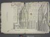
Jersey City.
from Combined atlas of the State of New Jersey and the County of Hudson : from actual survey, official records & private plans / by and under the direction of G. M. Hopkins ...
Jersey City, V. 1, Double Page Plate No. 9 [Map bounded by Summit Ave., Washburn St., Division St., Bright St.] / compiled under the direction of and published by G.M. Hopkins Co.
From V. 1
Jersey City, V. 1, Double Page Plate No. 2 [Map bounded by Monmouth St., 2nd St., Erie St., Grove St., Morris Canal] / compiled under the direction of and published by G.M. Hopkins Co.
From V. 1
Jersey City, V. 1, Double Page Plate No. 7 [Map bounded by Jersey Ave., Hoboken Ave., Provost St., 11th St.] / compiled under the direction of and published by G.M. Hopkins Co.
From V. 1
Jersey City, V. 1, Double Page Plate No. 10 [Map bounded by Central Ave., Franklin St., Jersey Ave., 12th St., Washborn St., Oakland Ave.] / compiled under the direction of and published by G.M. Hopkins Co.
From V. 1
Hudson River Vehicular Tunnel [Holland Tunnel]
From Manhattan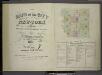
[Volume 7 Index Map.]
from Maps of the city of New York / surveyed under directions of insurance companies of said city.
Project for a submarine rail way between New-York and Jersey-City / by Jérôme Wenmaekers.
from Whole
Plan of the city of New York in North America : surveyed in the years 1766 & 1767 / B. Ratzer, lieutt. in His Majestys 60th or Royal American Regt. ; Thos. Kitchin, sculpt., engraver to His Late Royal Highness, the Duke of York, &c.
From Manhattan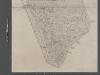
Map of New York City from Battery to 60th Street.
From Manhattan
[Volume 6 Index Map.]
from Maps of the city of New York / surveyed under directions of insurance companies of said city.
New map of that part of the city of New York south from 20th Street on the Hudson & 35th Street on the East River : showing the position of Greenwich, Washington and West Streets on the Hudson River, and Pearl, Water, Front, Cherry & Tompkins Sts. on the
from Manhattan
Use District Map Section No. 12
from Use district map / City of New York, Board of Estimate and Apportionment.
Height District Map Section No. 12
from Height district map / City of New York, Board of Estimate and Apportionment.
Road from Philadelphia to New York. (Maps) 14 and 15.
1 : 63360 Moore, S.S.
Area District Map Section No. 12
From Area district map.
New-York.
from The American traveller ; or, Guide through the United States, containing brief notices of the several states, cities, principal towns, canals and rail roads, etc. ; with tables of distances by stage, canal and steam boat routes ... by H.S. Tanner.
Jersey City, V. 1, Double Page Plate No. 40 [Map bounded by E. 40th St., New York Bay, E. 21st St.] / compiled under the direction of and published by G.M. Hopkins Co.
From V. 1
New York (City).
1 : 24000 Goodrich, S.G.
New York.
1 : 24000 Bradford, Thomas G.
Plan of New York
1 : 2000
Plan of New York &c.
Mitchell, Samuel Augustus Jr.
Map of the city of New York : with the adjacent cities of Brooklyn & Jersey City, & the village of Williamsburg / drawn & engraved by Story & Atwood, 151 Fulton St., N.Y.
from Manhattan
1 New York, Brooklyn, Jersey City.
1 : 18300 Watson, Gaylord
Map of the city of New York, 1850 / drawn for D.T. Valentine's Manual 1850, by G. Hayward.
from Manhattan
Map of the local boundaries of the Protestant Episcopal Churches of the city of New York.
from Manhattan
![Jersey City, V. 1, Double Page Plate No. 4 [Map bounded by Division St., 12th St., Jersey Ave., 2nd St.] / compiled under the direction of and published by G.M. Hopkins Co.](https://images-2.georeferencer.com/images/iiif/002411459214/full/,300/0/native.jpg)

