Maps of Jersey City

Jersey City, V. 1, Double Page Plate No. 9 [Map bounded by Summit Ave., Washburn St., Division St., Bright St.] / compiled under the direction of and published by G.M. Hopkins Co.
From V. 1
Jersey City, V. 1, Double Page Plate No. 8 [Map bounded by Prior St., 3rd St., Monmouth St., Grand St.] / compiled under the direction of and published by G.M. Hopkins Co.
From V. 1
Jersey City, V. 1, Double Page Plate No. 4 [Map bounded by Division St., 12th St., Jersey Ave., 2nd St.] / compiled under the direction of and published by G.M. Hopkins Co.
From V. 1
Jersey City, V. 1, Double Page Plate No. 15 [Map bounded by West Side Ave., Newark Ave., Summit Ave., Montgomery St.] / compiled under the direction of and published by G.M. Hopkins Co.
From V. 1
Jersey City, V. 1, Double Page Plate No. 13 [Map bounded by Liberty Ave., Manhattan Ave., Oakland Ave., Newark Ave.] / compiled under the direction of and published by G.M. Hopkins Co.
From V. 1
Jersey City, V. 1, Double Page Plate No. 17 [Map bounded by Madison Ave., Summit Ave., Balowin Ave., Montgomery St., Bright St., Van Horne St., Bramhall Ave.] / compiled under the direction of and published by G.M. Hopkins Co.
From V. 1
Jersey City, V. 1, Double Page Plate No. 2 [Map bounded by Monmouth St., 2nd St., Erie St., Grove St., Morris Canal] / compiled under the direction of and published by G.M. Hopkins Co.
From V. 1
Jersey City, V. 1, Double Page Plate No. 10 [Map bounded by Central Ave., Franklin St., Jersey Ave., 12th St., Washborn St., Oakland Ave.] / compiled under the direction of and published by G.M. Hopkins Co.
From V. 1
Plan of the city of New York in North America : surveyed in the years 1766 & 1767 / B. Ratzer, lieutt. in His Majestys 60th or Royal American Regt. ; Thos. Kitchin, sculpt., engraver to His Late Royal Highness, the Duke of York, &c.
From Manhattan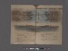
Hudson River Vehicular Tunnel [Holland Tunnel]
From Manhattan
Jersey City.
from Combined atlas of the State of New Jersey and the County of Hudson : from actual survey, official records & private plans / by and under the direction of G. M. Hopkins ...
Jersey City, V. 1, Double Page Plate No. 16 [Map bounded by Montgomery St., Summit Ave., Crescent Ave., Communipaw Ave., Olean Ave.] / compiled under the direction of and published by G.M. Hopkins Co.
From V. 1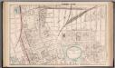
Jersey City - Plate I.
Hopkins, G.M.
Jersey City, V. 1, Double Page Plate No. 18 [Map bounded by Van Horne St., Grand St., Monmouth St., Jersey Ave., Phillip St.] / compiled under the direction of and published by G.M. Hopkins Co.
From V. 1
Jersey City, V. 1, Double Page Plate No. 3 [Map bounded by Jersey Ave., 11th St., Provost St., 2nd St.] / compiled under the direction of and published by G.M. Hopkins Co.
From V. 1
Topographical atlas of the City of New York / by Egbert L. Viele.
from Topographical atlas of the city of New York, / including the annexed territory showing original water courses and made land / prepared under the direction of Egbert L. Viele.
Jersey City, V. 1, Double Page Plate No. 40 [Map bounded by E. 40th St., New York Bay, E. 21st St.] / compiled under the direction of and published by G.M. Hopkins Co.
From V. 1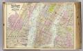
1 New York, Brooklyn, Jersey City.
1 : 18300 Watson, Gaylord
South Brooklyn, Park Slope, Brooklyn heights, Cobble Hill, Boerum Hill, Carroll Gardens, Red Hook, Gowanus, Windsor Terrace. (cont.)
From District 6
Topographical atlas of the city of New York, including the annexed territory showing original water courses and made land. / prepared under the direction of Egbert L. Viele.
From Topographical atlas of the city of New York, including the annexed territory showing original water courses and made land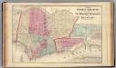
Hoboken, Jersey City.
1 : 19200 Beers, F. W. (Frederick W.)
Greenwich Village, West Village, Little Italy. (cont.)
From District 2
Lower Manhattan, The Battery, Wall Street, Civic Center, Governor's Island.
From District 1
Topographical map of the city of Brooklyn as reduced from the original maps on file showing farm lines, modern improvements, etc.
From Brooklyn
Jersey City
1 : 24000
Jersey City
1 : 24000
Jersey City
1 : 24000
Jersey City
1 : 24000
Jersey City
1 : 24000
![Jersey City, V. 1, Double Page Plate No. 9 [Map bounded by Summit Ave., Washburn St., Division St., Bright St.] / compiled under the direction of and published by G.M. Hopkins Co.](https://images-2.georeferencer.com/images/iiif/209894173099/full/,300/0/native.jpg)

