Maps of Liberty Island

Plan of the city of New York in North America : surveyed in the years 1766 & 1767 / B. Ratzer, lieutt. in His Majestys 60th or Royal American Regt. ; Thos. Kitchin, sculpt., engraver to His Late Royal Highness, the Duke of York, &c.
From Manhattan
Project for a submarine rail way between New-York and Jersey-City / by Jérôme Wenmaekers.
from Whole
New-York.
from The American traveller ; or, Guide through the United States, containing brief notices of the several states, cities, principal towns, canals and rail roads, etc. ; with tables of distances by stage, canal and steam boat routes ... by H.S. Tanner.
Road from Philadelphia to New York. (Maps) 14 and 15.
1 : 63360 Moore, S.S.
Height District Map Section No. 12
from Height district map / City of New York, Board of Estimate and Apportionment.
Use District Map Section No. 12
from Use district map / City of New York, Board of Estimate and Apportionment.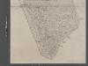
Map of New York City from Battery to 60th Street.
From Manhattan
Plan Of New York &c.
1 : 31300 Mitchell, Samuel Augustus
[Volume 2 Index Map]
from Maps of the city of New York.
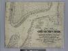
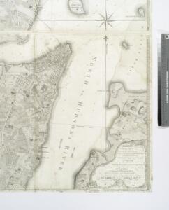
A plan of the city of New-York & its environs : to Greenwich, on the North or Hudsons River, and to Crown Point, on the East or Sound River, shewing the several streets, publick buildings, docks, fort & battery, with the true form & course of
from Charts and maps
Hudson River Vehicular Tunnel [Holland Tunnel]
From Manhattan
Area District Map Section No. 12; Area district map / City of New York, Board of Estimate and Apportionment.
from Area district map / City of New York, Board of Estimate and Apportionment. New York (N.Y.). Board of Estimate and Apportionment,
Key
From Atlas 107. Vol. 1, 1894.
[Volume 1 Index Map]
from Maps of the city of New York.
Hooker's new pocket plan of the city of New York / compiled & surveyed by William Hooker, engraver, No. 179 Water Street, New York, house, Willoughby St., Brooklyn.
from Manhattan
12C - N.Y. City (Aerial Set).
from Sectional aerial maps of the City of New York / [photographed and assembled under the direction of the chief engineer, July 1st, 1924].
The Firemen's guide : a map of the City of New-York, showing the fire districts, fire limits, hydrants, public cisterns, stations of engines, hooks & ladders, hose carts, &c.
from Manhattan
Outline and Index Map of Atlas of New York City.
from Atlas of the borough of Manhattan, city of New York.
Financial District map of New York City. Aero view of financial distrct above map.
From Manhattan
To His Excellency Sr. Henry Moore, Bart., captain general and governour in chief, in & over the Province of New York & the territories depending thereon in America, chancellor & vice admiral of the same, this plan of the city of New York, is
from Manhattan
Jersey City, V. 1, Double Page Plate No. 26 [Map bounded by New York bay] / compiled under the direction of and published by G.M. Hopkins Co.
From V. 1
Data for population from census of 1910, Borough of Manhattan
From Manhattan
Plan von der Stadt New-York.
from Manhattan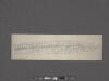
West Street [from Battery Park to Barrow Street.]
From Manhattan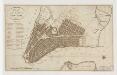
Plan of the city of New-York
1 : 12500 Tanner, Benjamin, 1775-1848 s.n.
To His Excellency Sr. Henry Moore, Bart., captain general and governour in chief in & over the province of New York & the territories depending thereon in America, chancellor & vice admiral of the same, this plan of the city of New York is mo
from Charts and maps
Hooker's new pocket plan of the city of New York
1 : 16000 Hooker, William, 1782-1856 W. Hooker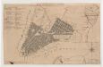
Plan of the city of New York
1 : 12500 Tiebout, Cornelius, 1777-1832 T. & J. Swords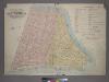
Outline & Index Map of Volume One, Atlas of New York City, Borough of Manhattan: Battery to Fourteenth Street.
from Atlas of the city of New York, borough of Manhattan. From actual surveys and official plans / by George W. and Walter S. Bromley.