Maps of Hoboken
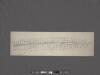
West Street [from Battery Park to Barrow Street.]
From Manhattan
Plan of the city of New-York : with the recent and intended improvements / drawn from actual survey by William Bridges, city surveyor, A.D. 1807 ; engraved by Peter Maverick.
from Manhattan
Plan von der Stadt New-York.
from Manhattan
City of New York, 1843.
from The cerographic atlas of the United States. By Sidney E. Morse, A.M., and Samuel Breese, A.M.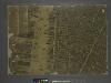
The city of New York / Will L. Taylor, chief draughtsman.
from Whole
Financial District map of New York City. Aero view of financial distrct above map.
From Manhattan
Plan of the city of New-York : the greater part from actual survey made expressly for the purpose (the rest from authentic documents) / by Thos. H. Poppleton, city surveyor ; P. Maverick sc. Newark.
from Manhattan
Key
From Atlas 107. Vol. 1, 1894.
Plan of the city of New-York : the greater part from actual survey made expressly for the purpose (the rest from authentic documents) / by Thos. H. Poppleton, city surveyor ; P. Maverick sc. Newark.
from Manhattan
Plan of the city of New-York / drawn from actual survey by C[a]simir Th. [G]oerck, and Joseph Fr. Mangin, city surveyors.
from Manhattan
The city of New York drawn from actual surveys as furnished by the several city surveyors
1 : 2350 [s.n.]
To His Excellency Sr. Henry Moore, Bart., captain general and governour in chief, in & over the Province of New York & the territories depending thereon in America, chancellor & vice admiral of the same, this plan of the city of New York, is
from Manhattan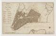
Plan of the city of New-York
1 : 12500 Tanner, Benjamin, 1775-1848 s.n.
[Volume 1 Index Map]
from Maps of the city of New York.
To His Excellency Sr. Henry Moore, Bart., captain general and governour in chief in & over the province of New York & the territories depending thereon in America, chancellor & vice admiral of the same, this plan of the city of New York is mo
from Charts and maps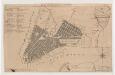
Plan of the city of New York
1 : 12500 Tiebout, Cornelius, 1777-1832 T. & J. Swords
Map of the city of New-York extending northward to Fiftieth St. / surveyed and drawn by John F. Harrison, C.E.
from Manhattan
Map showing the high and low water mark and the original city grants of lands under water made to various parties from 1686 to 1873, extending from Battery to Fifty-first Street, Hudson and East Rivers, New York City, also the several pier and bulkhead l
from Whole
New York, the English colonial city, 1730 / [cartographic material]
From Early New York history, portrayed in five maps
Map showing the old high water lines along the shores of Brooklyn & New York together the the pier lines as established by law.
From Manhattan
A plan of the city of New York from an actual survey
1 : 3200 Lyne, James reproduced by Henry Dunreath Tyler
"Where all the Village meet to eat" - An accurate and detailed map of Greenwich Village and Environment.
From Manhattan
Plan of the city of Brooklyn, L.I. / by William Perris.
from Brooklyn
Map of the city of New-York extending northward to Fiftieth St. / surveyed and drawn by John F. Harrison, C.E.
from Manhattan
To His Excellency Sr. Henry Moore, Bart., captain general and governour in chief in & over the province of New York & the territories depending thereon in America, chancellor & vice admiral of the same, this plan of the city of New York is most humbly inscribed
1 : 4800 Ratzer, Bernard s.n.
Sheet 3: [Bounded by Reade Street, Nassau Street, Pearl Street, Chatham Street, Oliver Street, (Pier Line) South Street, (Battery) State Street, Battery Place and West Street.]
from Plan of New York City, from the Battery to Spuyten Duyvil Creek. Showing every lot and building thereon; old farm lines, strreet numbers at the corners of blocks, railroads, steamboat landings, bulkhead and pier lines, etc. Based on the surveys made by Messrs. Randall & Blackwell, and on the special survey by J. F. Harrison.
A view of Collect Pond and its vicinity in the City of New York in 1793 : on which pond the first boat propelled by steam with paddle wheels or screw propellers was constructed by John Fitch, six years before Robert Fulton ... / by John Hutchings.
from Manhattan
City of New York
1 : 29000 Breese, S.
Part of Section 1 : New York City .
from Atlas of the city of New York, borough of Manhattan. From actual surveys and official plans / by George W. and Walter S. Bromley.
![West Street [from Battery Park to Barrow Street.]](https://images-2.georeferencer.com/images/iiif/446690203953/full/,300/0/native.jpg)

