Maps of Kings County

Data for population from census of 1910, Borough of Manhattan
From Manhattan
A new & accurate plan of the city of New York in the state of New York in North America, published in 1797.
from Manhattan
Plan of the city of Brooklyn, L.I. / by William Perris.
from Brooklyn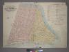
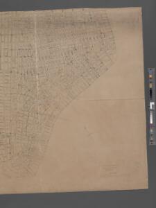
Outline & Index Map of Volume One, Atlas of New York City, Borough of Manhattan: Battery to Fourteenth Street.
from Atlas of the city of New York, borough of Manhattan. From actual surveys and official plans / by George W. and Walter S. Bromley.
Outline and Index Map of Atlas of New York City.
from Atlas of the borough of Manhattan, city of New York.
City Of New York.
1 : 17000 Tanner, Henry S.
The Firemen's guide : a map of the City of New-York, showing the fire districts, fire limits, hydrants, public cisterns, stations of engines, hooks & ladders, hose carts, &c.
from Manhattan
To His Excellency Sr. Henry Moore, Bart., captain general and governour in chief, in & over the Province of New York & the territories depending thereon in America, chancellor & vice admiral of the same, this plan of the city of New York, is
from Manhattan
City of New-York
1 : 12500 Burr, David H., 1803-1875 Edward Walker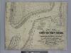
New map of that part of the city of New York south from 20th Street on the Hudson & 35th Street on the East River : showing the position of Greenwich, Washington and West Streets on the Hudson River, and Pearl, Water, Front, Cherry & Tompkins Sts. on the
from Manhattan
Map of the city of New York.
from Manhattan
Key
From Atlas 107. Vol. 1, 1894.
[Volume 2 Index Map]
from Maps of the city of New York.
Plan von der Stadt New-York.
from Manhattan
Plan of the city of New-York : the greater part from actual survey made expressly for the purpose (the rest from authentic documents)
1 : 7300 Poppleton, Thomas H Prior & Dunning
The city of New York drawn from actual surveys as furnished by the several city surveyors
1 : 2350 [s.n.]
To His Excellency Sr. Henry Moore, Bart., captain general and governour in chief in & over the province of New York & the territories depending thereon in America, chancellor & vice admiral of the same, this plan of the city of New York is mo
from Charts and maps
[Map bounded by Pier - Line 39-46, King St, Washington Street, Vestry St; Including West Street, Canal St, Desbrosses St, Watts St, Hoboken St, Spring St, Charlton St]
from Maps of the wharves & piers from the Battery to 61st street on the Hudson river and from the Battery to 41st street on the East river, New York. Surveyed by I.C. Buckhout, city surveyor.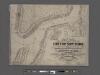
New map of the part of New York City 20th St. on the Hudson and 35th St. on the East River
From Manhattan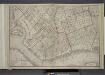
Brooklyn, Double Page Section 2; [Including Wards 1, 2, 3, 4, 5, 6, 10 ,11, 20, 22]
from Farm line map of the city of Brooklyn, from official records and surveys; comp. and drawn by Henry Fulton.
Plan of the city of New-York : with the recent and intended improvements / drawn from actual survey by William Bridges, city surveyor, A.D. 1807 ; engraved by Peter Maverick.
from Manhattan
Plan of the city of New York, 1808
1 : 7500 Longworth, David, 1765?-1821 Common Council
City of New-York.
1 : 17000 Mitchell, Samuel Augustus
Plan of the city of New-York : the greater part from actual survey made expressly for the purpose (the rest from authentic documents) / by Thos. H. Poppleton, city surveyor ; P. Maverick sc. Newark.
from Manhattan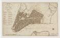
Plan of the city of New-York
1 : 12500 Tanner, Benjamin, 1775-1848 s.n.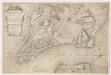
To His Excellency Sr. Henry Moore, Bart., captain general and governour in chief in & over the province of New York & the territories depending thereon in America, chancellor & vice admiral of the same, this plan of the city of New York is most humbly inscribed
1 : 4800 Ratzer, Bernard s.n.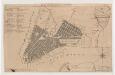
Plan of the city of New York
1 : 12500 Tiebout, Cornelius, 1777-1832 T. & J. Swords
Area District Map Section No. 12; Area district map / City of New York, Board of Estimate and Apportionment.
from Area district map / City of New York, Board of Estimate and Apportionment. New York (N.Y.). Board of Estimate and Apportionment,
Plan von New-York
Grosser Hand-Atlas über alle Theile der Erde in 170 Karten Meyer, J. Verlag des Bibliographischen Instituts