Maps of Hoboken

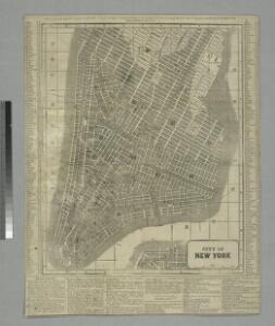
Map of the city of New York.
from Manhattan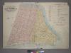
Outline & Index Map of Volume One, Atlas of New York City, Borough of Manhattan: Battery to Fourteenth Street.
from Atlas of the city of New York, borough of Manhattan. From actual surveys and official plans / by George W. and Walter S. Bromley.
Plan of the city of New-York : the greater part from actual survey made expressly for the purpose (the rest from authentic documents)
1 : 7300 Poppleton, Thomas H Prior & Dunning
Outline and Index Map of Atlas of New York City.
from Atlas of the borough of Manhattan, city of New York.
The Firemen's guide : a map of the City of New-York, showing the fire districts, fire limits, hydrants, public cisterns, stations of engines, hooks & ladders, hose carts, &c.
from Manhattan
Plan of the city of New-York : with the recent and intended improvements / drawn from actual survey by William Bridges, city surveyor, A.D. 1807 ; engraved by Peter Maverick.
from Manhattan
Firemen's guide and map of the city of New-York shewing the boundaries of the proposed new fire districts / enlered according to Act of Congress in the year 1840 by George Hayward
1 Mapa, b/n. Dins (?): Valentine's manual of New York city, 1841-1870 Hayward, George G. Hayward's Lith. G. Hayward's Lith.
City of New York, 1843.
from The cerographic atlas of the United States. By Sidney E. Morse, A.M., and Samuel Breese, A.M.
Plan von New-York, 1844.
from Manhattan
City of New-York
1 : 12500 Burr, David H., 1803-1875 Edward Walker
Topographical Atlas Of The City Of New York
1 : 12000 Viele, Egbert L.
Hooker's new pocket plan of the city of New York / compiled & surveyed by William Hooker, engraver, No. 179 Water Street, New York, house, Willoughby St., Brooklyn.
from Manhattan
Plan von der Stadt New York
1 : 68500 New York (New York)
Plan von New York
1 : 2000 New York (New York) Bibliographisches Institut
Map of the city of New York, shewing the original high water line and the location of the different farms and estates
Common Council
City of New-York.
1 : 17000 Mitchell, Samuel Augustus
Map of New York City from Battery to 60th Street.
From Manhattan
Map of the city of New-York extending northward to Fiftieth St. / surveyed and drawn by John F. Harrison, C.E.
from Manhattan
Plan von der Stadt New-York.
from Manhattan
Strangers guide through the city of New York : with the latest improvements / by H. Phelps.
from Manhattan
Plan of the city of New-York : the greater part from actual survey made expressly for the purpose (the rest from authentic documents) / by Thos. H. Poppleton, city surveyor ; P. Maverick sc. Newark.
from Manhattan
City of New-York / by David H. Burr.
from Manhattan
A new map of the city of New York : comprising all the late improvements, compiled and corrected from authentic documents.
from Manhattan
City of New-York / W. Kemble.
from Manhattan
Plan of the city of New-York : the greater part from actual survey made expressly for the purpose (the rest from authentic documents) / by Thos. H. Poppleton, city surveyor ; P. Maverick sc. Newark.
from Manhattan
The city of New York drawn from actual surveys as furnished by the several city surveyors
1 : 2350 [s.n.]
Hooker's new pocket plan of the city of New York
1 : 16000 Hooker, William, 1782-1856 W. Hooker
Plan von New-York
Grosser Hand-Atlas über alle Theile der Erde in 170 Karten Meyer, J. Verlag des Bibliographischen Instituts
Hooker's new pocket plan of the city of New York / compiled & surveyed by William Hooker, engraver, No. 179 Water Street, New York, house, Willoughby St., Brooklyn.
From Manhattan