Maps of Hoboken
Area District Map Section No. 12
From Area district map.
New map of the city of New York with part of Brooklyn & Williamsburg / by J. Calvin Smith ; engraved on steel by Stiles, Sherman & Smith.
from Manhattan
Map of the city of New York : with the adjacent cities of Brooklyn & Jersey City, & the village of Williamsburg / drawn & engraved by Story & Atwood, 151 Fulton St., N.Y.
from Manhattan
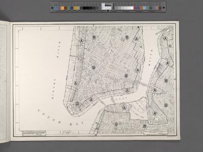
Height District Map Section No. 12
from Height district map / City of New York, Board of Estimate and Apportionment.
Plan of New York
1 : 2000
New York S.
1 : 21120 Letts, Son & Co.
Map of the local boundaries of the Protestant Episcopal Churches of the city of New York.
from Manhattan
Use District Map Section No. 12
from Use district map / City of New York, Board of Estimate and Apportionment.
Plan of New York &c.
Mitchell, Samuel Augustus Jr.
Map of the city of New York : with the adjacent cities of Brooklyn & Jersey City, & the village of Williamsburg / drawn & engraved by John M. Atwood, 145 Fulton St., N.Y.
from Manhattan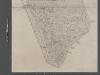
Map of New York City from Battery to 60th Street.
From Manhattan
Map of the city of New York, 1850 / drawn for D.T. Valentine's Manual 1850, by G. Hayward.
from Manhattan
Map of the city of New York with the adjacent cities of Brooklyn and Jersey City, and the village of Williamsburg
1 : 14000 Story & Atwood H. Phelps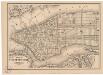
Map of the city of New York
1 mapa. Datat a partir de 1900 aproximadament. D. Appleton & Co.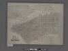
Map of the city of New York showing the original high water line and the location of the different farms and estates.
From Manhattan
Map of the city of New York : with street directory showing house-numbers, hotels, churches, banks, theatres, ferries, house-car, steam and elevated R.R'ds, &c
1 : 12670 Dripps, M. (Matthew) M. Dripps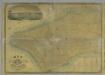
Map of the City of New York.
from Manhattan
New York (City).
1 : 24000 Goodrich, S.G.
New York.
1 : 24000 Bradford, Thomas G.
New-York.
from The American traveller ; or, Guide through the United States, containing brief notices of the several states, cities, principal towns, canals and rail roads, etc. ; with tables of distances by stage, canal and steam boat routes ... by H.S. Tanner.
This actual map and comparative plans showing 88 years growth of the City of New York : is inscribed to the citizens by the proprietor, David Longworth / G.B. King sc. N.Y. 1817 ; engraved by Jas. D. Stout.
from Manhattan
Map Of The City Of New York
1 : 12500 Ensign, Bridgman & Fanning
Topographical atlas of the city of New York, including the annexed territory showing original water courses and made land. / prepared under the direction of Egbert L. Viele.
From Topographical atlas of the city of New York, including the annexed territory showing original water courses and made land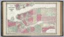
New York City and the Adjacent Cities.
1 : 20000 Colton, G.W.
City of New-York / W. Kemble.
from Manhattan
City of New-York / by David H. Burr.
from Manhattan
Map of the city of New-York / drawn by D.H. Burr, for "New York as it is, in 1834" ; engraved by S. Stiles & Co., New York.
from Manhattan
Map of New York City, south of 46th St. : showing new arrangement of docks, piers, and water frontage, also soundings and former high water line
1 : 7200 Dripps, M. (Matthew) Matthew Dripps
Plan von New-York, 1844.
from Manhattan