Maps of Hoboken

Maps of Hoboken

$title$

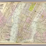
1 New York, Brooklyn, Jersey City.

1 : 18300 Watson, Gaylord
$title$

Map of New York, Brooklyn, Jersey City& c.

from Atlas of the Hudson River Valley from New York city to Troy, including a section of about 8 miles in width. Published by Watson & co. Compiled from official records and careful surveys, under the supervision of F. W. Beers.
$title$

Dutch Era Land Grants in Stokes Iconography sheet with Greenwich Village & Lower Manhattan.

from Manhattan
$title$

Map of the city of New York, 1850 / drawn for D.T. Valentine's Manual 1850, by G. Hayward.

from Manhattan
$title$

Map of the city of New York showing the original high water line and the location of the different farms and estates.

From Manhattan
$title$

The Great metropolis in 1804.

from Manhattan
$title$

Map of the city of New York

1 mapa. Datat a partir de 1900 aproximadament. D. Appleton & Co.
$title$

Sanitary and topographical map of the City and Island of New York ; prepared for the Council of Hygeine and Public Health of the Citizens Association under the direction of Egbert L. Viele, Topographical Engineer.

From Manhattan
$title$

Map of the city of New York : with street directory showing house-numbers, hotels, churches, banks, theatres, ferries, house-car, steam and elevated R.R'ds, &c

1 : 12670 Dripps, M. (Matthew) M. Dripps
$title$

Topographical Atlas Of The City Of New York

1 : 12000 Viele, Egbert L.
$title$

New York City.

1 : 20000 Johnson, A.J.
$title$

New map of the city of New York.

from Manhattan
$title$

Map of the local boundaries of the Protestant Episcopal Churches of the city of New York.

from Manhattan
$title$

New York City and the Adjacent Cities.

1 : 20000 Colton, G.W.
$title$

Greenwich Village, West Village, Little Italy. (cont.)

From District 2
$title$

Plan of the city of New York and of the island : as laid out by the commissioners, altered and arranged to the present time / engraved by J.F. Morin.

from Manhattan
$title$

New York.

from Manhattan
$title$

Plan of New York

1 : 2000
$title$

New York (City).

1 : 24000 Goodrich, S.G.
$title$

New York.

1 : 24000 Bradford, Thomas G.
$title$

Topographical atlas of the city of New York, including the annexed territory showing original water courses and made land. / prepared under the direction of Egbert L. Viele.

From Topographical atlas of the city of New York, including the annexed territory showing original water courses and made land
$title$

Plan of New York &c.

Mitchell, Samuel Augustus Jr.
$title$

Map of the City of New-York with part of Brooklyn and Williamsburgh : population in the year 1850: 450,000 inhabitants.

from Manhattan
$title$

Map of the City of New York.

from Manhattan
$title$

Map of New York City, south of 46th St. : showing new arrangement of docks, piers, and water frontage, also soundings and former high water line

1 : 7200 Dripps, M. (Matthew) Matthew Dripps
$title$

Map of the city of New York : with the adjacent cities of Brooklyn & Jersey City, & the village of Williamsburg / drawn & engraved by Story & Atwood, 151 Fulton St., N.Y.

from Manhattan
$title$

Map of the city of New York : with the adjacent cities of Brooklyn & Jersey City, & the village of Williamsburg / drawn & engraved by John M. Atwood, 145 Fulton St., N.Y.

from Manhattan
$title$

Map of New York City, south of 46th St.

From Manhattan
$title$

Hoboken, Jersey City.

1 : 19200 Beers, F. W. (Frederick W.)
© MapTiler © OpenStreetMap contributors
How does it work?
These instructions will show you how to find historical maps online.
Getting started
Type the place name in the search box to find the exact location. You can further adjust the search by zooming in and out.
Zoom
Zoom in and out with the buttons or use your mouse or touchpad natively.
Exact Area tool
Click here and draw a rectangle over the map to precisely define the search area.
Set filters
Narrow your search with advanced settings, such as Years (from/to), Fulltext, Publisher, etc.
Results
See the results of your search on the right side. You can scroll down to find more maps of this location.
?

Download OldMapsOnline Mobile