Maps of Germany

Neueste Karte von Deutschland, der Schweiz und Ober-Italien in 4 Blättern
1 : 1700000 Itálie severní Ravenstein, L. Bibl. Institut
Karte der Deutschen Bundesstaaten
1 : 3000000 Evropa střední Fried, Franz Artaria
Karte der Deutschen Bundesstaaten
1 : 3000000 Evropa střední Fried, Franz Artaria & Compag.
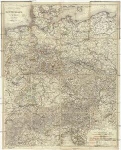
Charte von Deutschland
Evropa střední Berra, Marco Marco Berra
An Accurate Map of Germany
Mollova mapová sbírka Bennett Dilly, Charles
Neueste Karte von Deutschland, der Schweiz und Ober-Italien in 4 Blättern
1 : 1700000 Ravenstein, Ludwig Bibliographisches Institut
Karte von Deutschland
Grosser Hand-Atlas über alle Theile der Erde in 170 Karten Meyer, J. Verlag des Bibliographischen Instituts
Germany.
1 : 3170000 Tanner, Henry S.
Germany.
1 : 2429000 Johnson, A.J.
Germany.
1 : 3170000 Mitchell, Samuel Augustus
Germany.
1 : 3170000 Mitchell, Samuel Augustus
Karte von Deutschland, in IV Blättern entworfen im Jahre 1805, und nach den, durch die Bundesacte der Reinschen Conföderation, datirt Paris vom 12ten Julius 1806, ingleichen nach den, durch die verschiedenen Tausch- und Pacifications Verträge
1 : 875000
Deutsches Reich nebts Deutsch-Österreich und Schweiz
1 : 1825000 Evropa střední Handtke, Friedrich Carl Flemming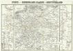
Post- und Eisenbahn- Karte von Deutschland
1 : 3800000 Evropa střední Wagner, Jan Eduard Kohl, Johann Georg Wagner u. Kohl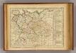
Allemagne, Boheme.
1 : 6000000 Lattre, Jean
Deutschland
1 : 2350000 Evropa střední Weiland, Karl Ferdinand Geographisches Institut
Deutschland
1 : 2350000 Evropa střední Weiland, Karl Ferdinand Geographisches Institut
Deutschland
1 : 2350000 Evropa střední Weiland, Karl Ferdinand Geographisches Institut
Germany.
1 : 3674880 Johnson, A.J.
Germany.
1 : 7200000 Seaman, James V.
Deutschland.
1 : 3400000 Radefeld, Carl Christian Franz, 1788-1874
[Neuer Atlas der ganzen Erde nach den neuesten Bestimmungen ... : XIV.] Gebirgs- und Gewaesser-Charte von Teutschland, oder der Teutsche Staaten-Bund
Entworfen und gezeichnet von Dr. F.W. Streit H. Leutemann sc. Leipzig : J.C. Hinrichs'sche Buchhandlung
Deutschland
1 : 4500000 Německo Grimm, Johann Ludwig Scharrer Simon Schropp
Empire of Germany and the 13 Cantons of Switzerland.
1 : 2700000 Carey, Mathew
Empire of Germany with the 13 Cantons of Switzerland.
1 : 2700000 Carey, Mathew
Empire of Germany with the 13 Cantons of Switzerland.
1 : 2700000 Carey, Mathew
Neueste Karte von Deutschland und den angränzenden Ländern
Evropa střední Schmidt, Johann Marius Friedrich Schropp, Simon Simon Schropp & C.
Norddeutsche Bundesstaaten, Süddeutsche Bundesstaaten
Evropa střední
Confederation Germanique.
1 : 4000000 Malte-Brun, Conrad, 1775-1826