Maps of Germany

Germany.
1 : 3170000 Tanner, Henry S.
Germany.
1 : 3170000 Mitchell, Samuel Augustus
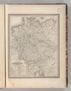
Germany.
1 : 3170000 Mitchell, Samuel Augustus
Karte von Deutschland
Grosser Hand-Atlas über alle Theile der Erde in 170 Karten Meyer, J. Verlag des Bibliographischen Instituts
Neueste Karte von Deutschland, der Schweiz und Ober-Italien in 4 Blättern
1 : 1700000 Ravenstein, Ludwig Bibliographisches Institut
Germany, Switzerland, N. Italy.
1 : 5300000 Mitchell, Samuel Augustus
[Neuer Atlas der ganzen Erde nach den neuesten Bestimmungen ... : XIV.] Gebirgs- und Gewaesser-Charte von Teutschland, oder der Teutsche Staaten-Bund
Entworfen und gezeichnet von Dr. F.W. Streit H. Leutemann sc. Leipzig : J.C. Hinrichs'sche Buchhandlung
Deutschland
1 : 2350000 Evropa střední Weiland, Karl Ferdinand Geographisches Institut
Deutschland
1 : 2350000 Evropa střední Weiland, Karl Ferdinand Geographisches Institut
Deutschland
1 : 2350000 Evropa střední Weiland, Karl Ferdinand Geographisches Institut
Confederation Germanique.
1 : 4000000 Malte-Brun, Conrad, 1775-1826
Oro-hydrographische Charte von Deutschland und der Schweiz
1 : 2890000 Evropa střední Weiland, Karl Ferdinand
Deutschland.
1 : 3400000 Radefeld, Carl Christian Franz, 1788-1874
Neueste Karte von Deutschland und den angränzenden Ländern
Evropa střední Schmidt, Johann Marius Friedrich Schropp, Simon Simon Schropp & C.
Tableau l'historie de la Confederation Germanique.
1 : 6200000 Duval, Henri


Deutschland.
1 : 2400000 Ziegler, J. M.
Deutschland's Eisenbahnen und Strassen-Netz mit seinen Anschlüssen im Ausland nebst Angabe der wichtigsten Flussdampfschiff-Stationen und Häfen für Seedampfer
1 : 2080000 Evropa střední Gräf, Adolf Hensgen, C. Geographisches Institut
Deutschland nach seinen oro-hydrographischen Verhältnissen
1 : 2570000 Evropa střední Gräf, Adolf Eyb, O. B. Geographisches Institut
Carte de l'Empire d'Alemagne
1 : 2900000 Mollova mapová sbírka Duval, Pierre Duval, Pierre
Germany Divided into Circles
1 : 6400000 Mollova mapová sbírka Moll, Herman Moll, Hermann
Germany.
1 : 2429000 Johnson, A.J.
Oro-hydrographische Charte von Deutschland und der Schweiz : insbesondere zur Uebersicht der grossen topographisch-militairischen Charten von Deutschland in 217 und von der Schweiz in 24 Blättern
1 : 3000000 entworfen von C.F. Weiland Weimar : im Verlage des Geograph. Instituts
Empire of Germany and the 13 Cantons of Switzerland.
1 : 2700000 Carey, Mathew
Empire of Germany with the 13 Cantons of Switzerland.
1 : 2700000 Carey, Mathew
Empire of Germany with the 13 Cantons of Switzerland.
1 : 2700000 Carey, Mathew
Norddeutsche Bundesstaaten, Süddeutsche Bundesstaaten
Evropa střední
Germany.
1 : 4200000 Greenleaf, Jeremiah
Germany.
1 : 4200000 Greenleaf, Jeremiah