Maps of Germany

Norddeutsche Bundesstaaten, Süddeutsche Bundesstaaten
Evropa střední
Deutschland.
1 : 3400000 Radefeld, Carl Christian Franz, 1788-1874
Deutschland.
1 : 2400000 Ziegler, J. M.
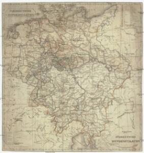
Tableau l'historie de la Confederation Germanique.
1 : 6200000 Duval, Henri
Deutschland
1 : 2350000 Evropa střední Weiland, Karl Ferdinand Geographisches Institut
Deutschland
1 : 2350000 Evropa střední Weiland, Karl Ferdinand Geographisches Institut
Deutschland
1 : 2350000 Evropa střední Weiland, Karl Ferdinand Geographisches Institut
Neuste Post Karte von Deutschland und dessen angrenzenden Laender
Evropa střední Walch, Johann bey Ioh. Walch
Deutschland
Geographischer Atlas über alle Theile der Erde Ziegler, Jakob Melchior Verlag von Dietrich Reimer
Nova totius Germaniae descriptio
1 : 3640000 Evropa střední Hofmann, Johann Johann Hofman[n]
Karte von Deutschland
Grosser Hand-Atlas über alle Theile der Erde in 170 Karten Meyer, J. Verlag des Bibliographischen Instituts
Deutschland.
1 : 2300000 Weiland, C. F. (Carl Ferdinand), d. 1847
Deutschland
Geographischer Atlas über alle Theile der Erde Ziegler, Jakob Melchior Verlag von Joh. Wurster um Comp.
Deutschland.
1 : 4800000 Reichard, C. G.
Confederation Germanique.
1 : 4000000 Malte-Brun, Conrad, 1775-1826
[Atlas zur Geschichte von Bayern] : Va. Die Besitzungen der Wittelsbacher im XIVt. Jahrhundert. Vb. Das Churfürstenthum Pfalz am Rheine und das Herzogthum Zweybrücken
K. v. Spruner W. Hase jun. sc. [Gotha : Perthes]
[Neuer Atlas der ganzen Erde nach den neuesten Bestimmungen ... : XIV.] Gebirgs- und Gewaesser-Charte von Teutschland, oder der Teutsche Staaten-Bund
Entworfen und gezeichnet von Dr. F.W. Streit H. Leutemann sc. Leipzig : J.C. Hinrichs'sche Buchhandlung
Germania Antiqua in IV. Magnos Populos, in Minores Populos, et in Minimos, distincta. Illyricum Occidentis cum Itineribus Romanis
1 : 2900000 Mollova mapová sbírka Sanson, Nicolas Robert de Vaugondy, Gilles
Deutschland
1 : 2350000 Evropa střední Weiland, Karl Ferdinand Geographisches Institut
Germany.
1 : 3170000 Mitchell, Samuel Augustus
Germany.
1 : 3170000 Mitchell, Samuel Augustus
Germany.
1 : 3674880 Johnson, A.J.
Germany.
1 : 7200000 Seaman, James V.
Germania magna ausser der Cimbrischen Halbinsel
Německo Kruse, Friedrich Leidenfrost, E. in Ernst Kleins literarischem und geographishem Comptoir
Deutschland's Eisenbahnen und Strassen-Netz mit seinen Anschlüssen im Ausland nebst Angabe der wichtigsten Flussdampfschiff-Stationen und Häfen für Seedampfer
1 : 2080000 Evropa střední Gräf, Adolf Hensgen, C. Geographisches Institut
Deutschland nach seinen oro-hydrographischen Verhältnissen
1 : 2570000 Evropa střední Gräf, Adolf Eyb, O. B. Geographisches Institut
Dějiště války třicetileté po míru vestfálském

Carte de l'Empire d'Alemagne
1 : 2900000 Mollova mapová sbírka Duval, Pierre Duval, Pierre
Germany.
1 : 3170000 Tanner, Henry S.