Maps of Germany

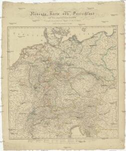
Neueste Karte von Deutschland und den angränzenden Ländern
Evropa střední Schmidt, Johann Marius Friedrich Schropp, Simon Simon Schropp & C.
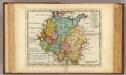
Confederation Germanique.
1 : 4000000 Malte-Brun, Conrad, 1775-1826
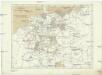
Neueste Charte von Deutschlandt ...

Karte der Bäder und Kurorte Deutschlands, Oesterreich-Ungarns und der Schweiz
1 : 2000000 Německo Liebenow, W. Bäder-Almanach
Karte der Bäder und Kurorte Deutschlands, Oesterreich-Ungarns und der Schweiz
1 : 2000000 Německo Liebenow, W. Bäder-Almanach
Deutschland von Rudolf von Habsburg bis Maximilian I, 1275-1495.
1 : 3800000 Spruner von Merz, Karl
Deutschland von 1792 bis zur Gegenwart.
1 : 3800000 Spruner von Merz, Karl
General-Charte von Teutschland nach den besten Quellen bearbeitet und den neuesten politischen Veraenderungen begrenzt
1 : 2027520

[Atlas zur Geschichte von Bayern] : Va. Die Besitzungen der Wittelsbacher im XIVt. Jahrhundert. Vb. Das Churfürstenthum Pfalz am Rheine und das Herzogthum Zweybrücken
K. v. Spruner W. Hase jun. sc. [Gotha : Perthes]
Deutschland
E. von Sydow's Schul-Atlas in sechs und dreissig Karten Sydow, Emil von bei Justus Perthes
Deutschland unter den saechsischen & fraenkischen Kaisern bis zu den Hohenstaufen.
1 : 3800000 Spruner von Merz, Karl
Germaniae Veteris, typus. [Karte], in: Theatrum orbis terrarum, S. 473.
1 Karte aus Atlas Ortelius, Abraham Vrients, Jan Baptista
Die Ältesten Karten von Deutschland
Deutschland zu Anfang des dreissigjährigen Krieges, 1618
Evropa střední Goedsche & Steinmetz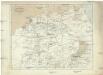
Deutschland unter den sächsischen und fränkischen Kaisern bis 1138
Evropa střední Goedsche & Steinmetz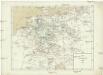
Deutschland im Jahre 1792
Evropa střední Goedsche & Steinmetz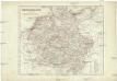
Deutschland unter den Hohenstaufen
1 : 6000000 Evropa střední Goedsche & Steinmetz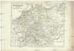
Deutschland zur Zeit der Reformation
1 : 6000000 Evropa střední Goedsche & Steinmetz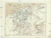
Deutschland im Jahre 1512
Evropa střední Goedsche & Steinmetz
Germaniae Veteris, typus. [Karte], in: Novus atlas absolutissimus, Bd. 2, S. 8.
1 Karte aus Atlas Janssonius Offizin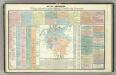
Tableau l'historie de la Confederation Germanique.
1 : 6200000 Duval, Henri
Deutschland's Eisenbahnen und Strassen-Netz mit seinen Anschlüssen im Ausland nebst Angabe der wichtigsten Flussdampfschiff-Stationen und Häfen für Seedampfer
1 : 2080000 Evropa střední Gräf, Adolf Hensgen, C. Geographisches Institut
Deutschland nach seinen oro-hydrographischen Verhältnissen
1 : 2570000 Evropa střední Gräf, Adolf Eyb, O. B. Geographisches Institut
Charte von Deutschland

La Germanie 511 a 741.
1 : 6300000 Houze, Antoine Philippe
Composite: Carte Generale des Etats composant La Confederation Germanique.
1 : 2750000 Vivien de St Martin, L.
Reichskreise 1792
Deutschland Reichskreis Kunz, Andreas ; Moeschl, Joachim Robert
L'Allemagne.
1 : 3700000 Clouet, J. B. L. (Jean-Baptiste Louis), b. 1730
(L'Allemagne)
1 : 12000000 Bruyset, Jean-Marie; Schneider, J. H.