Maps of Germany

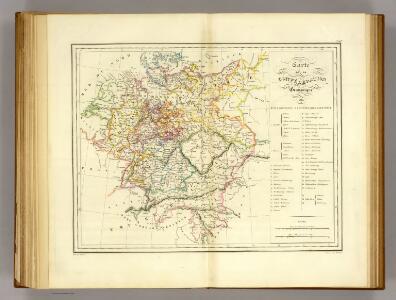
Confederation Germanique.
1 : 4000000 Malte-Brun, Conrad, 1775-1826
Deutschland's Eisenbahnen und Strassen-Netz mit seinen Anschlüssen im Ausland nebst Angabe der wichtigsten Flussdampfschiff-Stationen und Häfen für Seedampfer
1 : 2080000 Evropa střední Gräf, Adolf Hensgen, C. Geographisches Institut
Deutschland nach seinen oro-hydrographischen Verhältnissen
1 : 2570000 Evropa střední Gräf, Adolf Eyb, O. B. Geographisches Institut
Karte der Bäder und Kurorte Deutschlands, Oesterreich-Ungarns und der Schweiz
1 : 2000000 Německo Liebenow, W. Bäder-Almanach
Karte der Bäder und Kurorte Deutschlands, Oesterreich-Ungarns und der Schweiz
1 : 2000000 Německo Liebenow, W. Bäder-Almanach
Deutschland unter den saechsischen & fraenkischen Kaisern bis zu den Hohenstaufen.
1 : 3800000 Spruner von Merz, Karl
Neueste Karte von Deutschland und den angränzenden Ländern
Evropa střední Schmidt, Johann Marius Friedrich Schropp, Simon Simon Schropp & C.
Tableau l'historie de la Confederation Germanique.
1 : 6200000 Duval, Henri
La Germanie, 275 de J.C.
1 : 6300000 Houze, Antoine Philippe
Neueste Charte von Deutschlandt ...

Germaniae Veteris, typus. [Karte], in: Theatrum orbis terrarum, S. 473.
1 Karte aus Atlas Ortelius, Abraham Vrients, Jan Baptista
Nationalitäts-Karte Deutschland
1 : 3800000 Mollova mapová sbírka Kiepert, Heinrich
Mitteleuropa 1989
Mitteleuropa Kunz, Andreas ; Treiling, Thomas
Composite: Carte Generale des Etats composant La Confederation Germanique.
1 : 2750000 Vivien de St Martin, L.
Deutschland von Rudolf von Habsburg bis Maximilian I, 1275-1495.
1 : 3800000 Spruner von Merz, Karl
Germania Antiqua.
1 : 4900000 Delamarche, Felix
La Germanie 511 a 741.
1 : 6300000 Houze, Antoine Philippe
Germaniae Veteris, typus. [Karte], in: Theatrum orbis terrarum, S. 380.
1 Karte aus Atlas Ortelius, Abraham
Mitteleuropa 1949
Mitteleuropa Kunz, Andreas ; Treiling, Thomas
Mitteleuropa 1922
Mitteleuropa Kunz, Andreas ; Moeschl, Joachim Robert
Mitteleuropa 1956
Mitteleuropa Kunz, Andreas ; Treiling, Thomas
Mitteleuropa 1945
Mitteleuropa Kunz, Andreas ; Treiling, Thomas
Mitteleuropa 1990
Mitteleuropa Kunz, Andreas ; Treiling, Thomas

Tabula Novissima Totius Germaniae
1 : 1300000 Mollova mapová sbírka Eisenschmidt, Johann Caspar Homann, Johann Baptista
Germania magna ausser der Cimbrischen Halbinsel
Německo Kruse, Friedrich Leidenfrost, E. in Ernst Kleins literarischem und geographishem Comptoir
Mitteleuropa 1993
Mitteleuropa Kunz, Andreas ; Treiling, Thomas
Deutschland von 1792 bis zur Gegenwart.
1 : 3800000 Spruner von Merz, Karl
Germaniae Veteris, typus. [Karte], in: Novus atlas absolutissimus, Bd. 2, S. 8.
1 Karte aus Atlas Janssonius Offizin