Maps of Germany

Neueste Charte von Deutschlandt ...

Deutschland von 1792 bis zur Gegenwart.
1 : 3800000 Spruner von Merz, Karl
Deutschland von Rudolf von Habsburg bis Maximilian I, 1275-1495.
1 : 3800000 Spruner von Merz, Karl
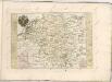
Germaniae Veteris, typus. [Karte], in: Theatrum orbis terrarum, S. 473.
1 Karte aus Atlas Ortelius, Abraham Vrients, Jan Baptista
Deutschland unter den saechsischen & fraenkischen Kaisern bis zu den Hohenstaufen.
1 : 3800000 Spruner von Merz, Karl

Societas Iesu Germana Sive Assistentia Germaniae
1 : 2600000 Mollova mapová sbírka Seutter, Matthäus Seutter, Georg Matthäus Seutter, Matthäus
Deutschland von 1495 bis 1618.
1 : 3800000 Spruner von Merz, Karl
Deutschland zu Anfang des dreissigjährigen Krieges, 1618
Evropa střední Goedsche & Steinmetz
Deutschland unter den sächsischen und fränkischen Kaisern bis 1138
Evropa střední Goedsche & Steinmetz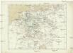
Deutschland im Jahre 1792
Evropa střední Goedsche & Steinmetz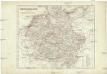
Deutschland unter den Hohenstaufen
1 : 6000000 Evropa střední Goedsche & Steinmetz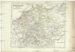
Deutschland zur Zeit der Reformation
1 : 6000000 Evropa střední Goedsche & Steinmetz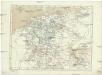
Deutschland im Jahre 1512
Evropa střední Goedsche & Steinmetz
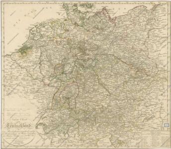
Charte von Teutschland
1 : 2210000 Německo Güssefeld, Franz L. im Verlage des geographischen Instituts
Composite: Carte Generale des Etats composant La Confederation Germanique.
1 : 2750000 Vivien de St Martin, L.
Tabula Novissima Totius Germaniae
1 : 1300000 Mollova mapová sbírka Eisenschmidt, Johann Caspar Homann, Johann Baptista
Kharte von Deutschland nach der neuesten Eintheilung, zufolge der Bestimmung des Wiener Congresses und des Pariser Frieden von 1815 entworfen
1 : 2300000 Augsburg : bei Joh. Walch
Nationalitäts-Karte Deutschland
1 : 3800000 Mollova mapová sbírka Kiepert, Heinrich
Imperium Romano-Germanicum in suos circulos electorat. et status
1 : 5100000 Evropa střední Seutter, Matthäus Lotter, Tobias Conrad apud Matth. Seutter
Post- & Reise- Karte von Deutschland und den nachbar Staaten
1 : 2200000 Evropa střední Kunsch, H. Handtke, F. C. Flemming
Charte von Deutschland

Deutschland und anliegende Länder, zur Übersicht der Eisenbahnen und Hauptstrassen
Hand-Atlas über alle Theile der Erde nach dem neuesten Zustande und über das Weltgebäude Stieler, Adolf bei Justus Perthes
Germaniae Veteris, typus. [Karte], in: Theatrum orbis terrarum, S. 380.
1 Karte aus Atlas Ortelius, Abraham
Germania Antiqua.
1 : 4900000 Delamarche, Felix
Eisen-Bahn-Atlas von Deutschland, Belgien, Elsass und dem nördlichsten Theile von Italien
Stülpnagel, Friedrich von ; Bär, J.C. Justus Perthes
Reichskreise 1555
Deutschland Kunz, Andreas ; Moeschl, Joachim Robert
Charte das Deutsche Reich nach seinen Kreisen und deren Unterabtheilungen vorstellend
1 : 2660000 Francie Güssefeld, Franz L. von den Homännischen Erben
Charte das Deutsche Reich nach seinen Kreisen und deren Unterabtheilungen vorstellend
1 : 2660000 Evropa střední Güssefeld, Franz L. von den Homännischen Erben