Maps of Germany

Post- & Reise- Karte von Deutschland und den nachbar Staaten
1 : 2200000 Evropa střední Kunsch, H. Handtke, F. C. Flemming
Germaniae Veteris, typus. [Karte], in: Theatrum orbis terrarum, S. 380.
1 Karte aus Atlas Ortelius, Abraham
Deutschland, Übersicht der Politischen Eintheilung
Hand-Atlas über alle Theile der Erde und über das Weltgebäude Stieler, Adolf Justus Perthes
Deutschland, Niederlande, Belgien und Schweiz
Hand-Atlas über alle Theile der Erde nach dem neuesten Zustande und über das Weltgebäude Stieler, Adolf bei Justus Perthes
Deutschland und benachbarte Länder. Zur Übersicht der Eisenbahnen und Dampfschiffahrten
Hand-Atlas über alle Theile der Erde und über das Weltgebäude Stieler, Adolf Justus Perthes
Das Deutsche Reich und seine Nachbarländer. Zur Übersicht der Eisenbahnen und Dampfschiffahrten
Handatlas über alle Theile der Erde und über das Weltgebäude Stieler, Adolf Justus Perthes
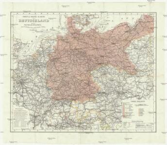
Reise - Karte von Deutschland und den Nachbarstaaten

Germaniae Veteris, typus. [Karte], in: Le théâtre du monde, ou, Nouvel atlas contenant les chartes et descriptions de tous les païs de la terre, Bd. 1, S. 320.
1 Karte aus Atlas Blaeu, Willem Janszoon und Blaeu, Joan Blaeu, Willem Janszoon
Germaniae Veteris, typus. [Karte], in: Theatrum orbis terrarum, S. 473.
1 Karte aus Atlas Ortelius, Abraham Vrients, Jan Baptista
Germaniae Veteris, typus. [Karte], in: Novus Atlas, das ist, Weltbeschreibung, Bd. 1, S. 291.
1 Karte aus Atlas Blaeu, Joan Blaeu, Willem Janszoon
General Karte von Deutschland

Allemagne. Politique et économique. n133
1 : 2600000 A. Taride Paris : A.Taride
Germaniae Veteris, typus. [Karte], in: Theatrum orbis terrarum, sive, Atlas novus, Bd. 1, S. 316.
1 Karte aus Atlas Blaeu, Joan Blaeu, Willem Janszoon
Germaniae Veteris, typus. [Karte], in: Gerardi Mercatoris et I. Hondii Newer Atlas, oder, Grosses Weltbuch, Bd. 1, S. 135.
1 Karte aus Atlas Mercator, Gerhard und Hondius, Jodocus Jansson, Jan
Deutschland von 1649 bis 1792.
1 : 3800000 Spruner von Merz, Karl
Germania Augustiniana exhibens provincias ord. Fr.Fr. eremit. S. Augustini una cum monasterys et residentiis ad aßistentiam generalem utriusque Germaniae, Bohemiae, Moraviae, Poloniae, Hungariae, et Hyberniae pertinentibus
1 : 2600000 Evropa střední Seutter, Matthäus Seutter, Johann Matthäus Matthaeus Seutter
Germaniae Typus. [Karte], in: Theatrum orbis terrarum, S. 159.
1 Karte aus Atlas Ortelius, Abraham Vrients, Jan Baptista
Germania Antiqua.
1 : 4900000 Delamarche, Felix
Neueste geographische Post und Reise Charte von Deutschland und Preussen
1 : 2320000 Německo Reymann, Gottlob Daniel Berghaus, Heinrich Karl Wilhelm im Magazin für Kunst, Geographie & Musik
Deutschland Politische Uebersicht
Plastischer Schul-Atlas über alle Theile der Erde : in 24 Karten Woldermann, G Verlag von P. Eckerlein
Mitteleuropa 1989
Mitteleuropa Kunz, Andreas ; Treiling, Thomas
Deutschland, Ubersicht Des Deutschen Reichs.
1 : 3700000 Berghaus, Hermann
Deutschland Und Benachbarte Lander. Zur Ubersicht Der Eisenbahnen Und Dampfschiffahrten.
1 : 3700000 Vogel, C.
Tabula Germaniae
1 : 2780000 Evropa střední Visscher, Claes Jansz. Broeck, Abraham van den Claes Ianßen Visscher excudebat
Post Charte der Östereichis = Teutschen, Preussischen u. Teut. Bund. Staaten...

Post und Reisekartre von Deutschland...

Deutschland von 1495 bis 1618.
1 : 3800000 Spruner von Merz, Karl
[Deutschland, Niederlande, Belgien und Schweiz; National-, Sprach-, Dialect- Verschiedenheit]
Zweiter Band, enthaltend in vier Abtheilungen die Vertheilung der Organismen: 5. Pflanzen-Geographie, 6. Thier-Geographie, 7. Anthropographie, 8. Ethnographie Humboldt, Alexander von Verlag von Justus Perthes