Maps of Germany

Imperium Romano-Germanicum in suos circulos electorat. et status
1 : 5100000 Evropa střední Seutter, Matthäus Lotter, Tobias Conrad apud Matth. Seutter
Deutschland von 1495 bis 1618.
1 : 3800000 Spruner von Merz, Karl
Germaniae Veteris, typus. [Karte], in: Theatrum orbis terrarum, S. 473.
1 Karte aus Atlas Ortelius, Abraham Vrients, Jan Baptista
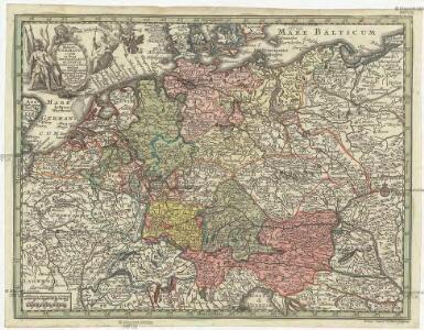
Societas Iesu Germana Sive Assistentia Germaniae
1 : 2600000 Mollova mapová sbírka Seutter, Matthäus Seutter, Georg Matthäus Seutter, Matthäus
Charte das Deutsche Reich nach seinen Kreisen und deren Unterabtheilungen vorstellend
1 : 2660000 Francie Güssefeld, Franz L. von den Homännischen Erben
Charte das Deutsche Reich nach seinen Kreisen und deren Unterabtheilungen vorstellend
1 : 2660000 Evropa střední Güssefeld, Franz L. von den Homännischen Erben
Karte von Teutschland
Německo Ritter, C.
Eisen-Bahn-Atlas von Deutschland, Belgien, Elsass und dem nördlichsten Theile von Italien
Stülpnagel, Friedrich von ; Bär, J.C. Justus Perthes
Neue und vollstaendige Postkarte durch ganz Deutschland und durch die angränzenden Theile der benachbarten Länder
1 : 1465000 Evropa střední Thurn-Taxis, Karel Anselm von denen Homaennischen Erben
Neue und vollstaendige Postkarte durch ganz Deutschland und durch die angränzenden Theile der benachbarten Länder
1 : 1465000 Evropa střední Thurn-Taxis, Karel Anselm von denen Homaennischen Erben
Neue und vollständige Postkarte durch ganz Deutschland und durch die angränzende Theile der benachbarten Länder
1 : 1465000 Evropa střední Heger, Franz Joseph Emmerich Joseph von denen Homaennischen Erben
Composite: Carte Generale des Etats composant La Confederation Germanique.
1 : 2750000 Vivien de St Martin, L.

Tabula Novissima Totius Germaniae
1 : 1300000 Mollova mapová sbírka Eisenschmidt, Johann Caspar Homann, Johann Baptista
Teutschland
Neuester Schul-Atlas Walch, Johann im Verlag bei Joh. Walch
[Deutschland, Niederlande, Königreich Belgien und Schweiz]
Schul-Atlas über alle Theile der Erde nach dem neuesten Zustande, und über das Weltgebäude Stieler, Adolf bei Justus Perthes
Germany.
1 : 5200000 Darton, William
Germany.
1 : 6000000 Carey, Mathew
Germany.
1 : 6000000 Carey, Mathew
Post- & Reise- Karte von Deutschland und den nachbar Staaten
1 : 2200000 Evropa střední Kunsch, H. Handtke, F. C. Flemming
Deutschland und anliegende Länder, zur Übersicht der Eisenbahnen und Hauptstrassen
Hand-Atlas über alle Theile der Erde nach dem neuesten Zustande und über das Weltgebäude Stieler, Adolf bei Justus Perthes
Post und Reise Karte von Deutschland und den benachbarten Ländern
Evropa střední Schmitfeldt, Georg Mollo, Eduard bey Eduard Mollo
Germaniae Veteris, typus. [Karte], in: Theatrum orbis terrarum, S. 380.
1 Karte aus Atlas Ortelius, Abraham
Germania Antiqua.
1 : 4900000 Delamarche, Felix
Neueste Charte von Deutschlandt ...

Deutschland von 1792 bis zur Gegenwart.
1 : 3800000 Spruner von Merz, Karl
Carte exacte des postes et routes de l'Empire d'Allemagne divisee en ses cercles.
1 : 2500000 Covens et Mortier
Kharte von Deutschland nach der neuesten Eintheilung, zufolge der Bestimmung des Wiener Congresses und des Pariser Frieden von 1815 entworfen
1 : 2300000 Augsburg : bei Joh. Walch
Charte von Deutschland