Maps of Germany

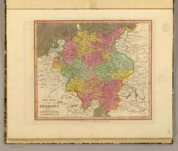
Germany.
1 : 5200000 Darton, William
Germaniae Veteris, typus. [Karte], in: Theatrum orbis terrarum, S. 380.
1 Karte aus Atlas Ortelius, Abraham
Deutschland, Niederlande, Belgien und Schweiz
Hand-Atlas über alle Theile der Erde nach dem neuesten Zustande und über das Weltgebäude Stieler, Adolf bei Justus Perthes
GERMANIAE | VETERIS | typus.
[Amsterdam : Joan Blaeu]
[Deutschland, Niederlande, Belgien und Schweiz; National-, Sprach-, Dialect- Verschiedenheit]
Zweiter Band, enthaltend in vier Abtheilungen die Vertheilung der Organismen: 5. Pflanzen-Geographie, 6. Thier-Geographie, 7. Anthropographie, 8. Ethnographie Humboldt, Alexander von Verlag von Justus Perthes
Germaniae Veteris, typus. [Karte], in: Theatrum orbis terrarum, S. 473.
1 Karte aus Atlas Ortelius, Abraham Vrients, Jan Baptista
Post- & Reise- Karte von Deutschland und den nachbar Staaten
1 : 2200000 Evropa střední Kunsch, H. Handtke, F. C. Flemming
Teutschland
Neuester Schul-Atlas Walch, Johann im Verlag bei Joh. Walch
Deutschland, Übersicht der Politischen Eintheilung
Hand-Atlas über alle Theile der Erde und über das Weltgebäude Stieler, Adolf Justus Perthes
Germaniae Veteris, typus. [Karte], in: Novus Atlas, das ist, Weltbeschreibung, Bd. 1, S. 291.
1 Karte aus Atlas Blaeu, Joan Blaeu, Willem Janszoon
Germaniae Veteris, typus. [Karte], in: Theatrum orbis terrarum, sive, Atlas novus, Bd. 1, S. 316.
1 Karte aus Atlas Blaeu, Joan Blaeu, Willem Janszoon
Germaniae Typus. [Karte], in: Theatrum orbis terrarum, S. 159.
1 Karte aus Atlas Ortelius, Abraham Vrients, Jan Baptista
Mitteleuropa 1839
Mitteleuropa Kunz, Andreas ; Moeschl, Joachim Robert
Mitteleuropa 1990
Mitteleuropa Kunz, Andreas ; Treiling, Thomas
Deutschland und benachbarte Länder. Zur Übersicht der Eisenbahnen und Dampfschiffahrten
Hand-Atlas über alle Theile der Erde und über das Weltgebäude Stieler, Adolf Justus Perthes
Deutschland von 1649 bis 1792.
1 : 3800000 Spruner von Merz, Karl
Das Deutsche Reich und seine Nachbarländer. Zur Übersicht der Eisenbahnen und Dampfschiffahrten
Handatlas über alle Theile der Erde und über das Weltgebäude Stieler, Adolf Justus Perthes
Deutschland nach seiner Eintheilung in zehn Kreise
Francie Pütz, Wilhelm Biecker, Aug.
Mitteleuropa 1820
Mitteleuropa Kunz, Andreas ; Moeschl, Joachim Robert
General Charte von Teutschland mit Angabe aller Post-Strassen von Paris bis Warschau, und von Triest bis Stralsund
1 : 1760000 Evropa střední Güssefeld, Franz L. Geograph. Institut

Mitteleuropa 1937
Mitteleuropa Kunz, Andreas ; Moeschl, Joachim Robert
Post Charte der Östereichis = Teutschen, Preussischen u. Teut. Bund. Staaten...
Germaniae Veteris, typus. [Karte], in: Le théâtre du monde, ou, Nouvel atlas contenant les chartes et descriptions de tous les païs de la terre, Bd. 1, S. 320.
1 Karte aus Atlas Blaeu, Willem Janszoon und Blaeu, Joan Blaeu, Willem Janszoon
Deutschland von 1495 bis 1618.
1 : 3800000 Spruner von Merz, Karl
Mitteleuropa 1989
Mitteleuropa Kunz, Andreas ; Treiling, Thomas
Mitteleuropa 1812
Mitteleuropa Kunz, Andreas ; Moeschl, Joachim Robert
Composite: Carte Generale des Etats composant La Confederation Germanique.
1 : 2750000 Vivien de St Martin, L.
Mitteleuropa 2003
Mitteleuropa Kunz, Andreas ; Treiling, Thomas