Maps of Germany
Deutschland zu Anfang des dreissigjährigen Krieges, 1618
Evropa střední Goedsche & Steinmetz
Deutschland unter den sächsischen und fränkischen Kaisern bis 1138
Evropa střední Goedsche & Steinmetz
Deutschland im Jahre 1792
Evropa střední Goedsche & Steinmetz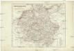
Deutschland unter den Hohenstaufen
1 : 6000000 Evropa střední Goedsche & Steinmetz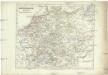
Deutschland zur Zeit der Reformation
1 : 6000000 Evropa střední Goedsche & Steinmetz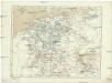
Deutschland im Jahre 1512
Evropa střední Goedsche & Steinmetz
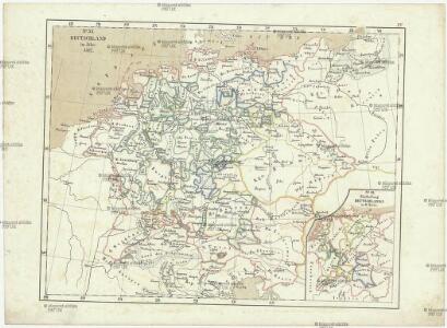
Deutschland von 1792 bis zur Gegenwart.
1 : 3800000 Spruner von Merz, Karl
Deutschland von Rudolf von Habsburg bis Maximilian I, 1275-1495.
1 : 3800000 Spruner von Merz, Karl
Deutschland von 1495 bis 1618.
1 : 3800000 Spruner von Merz, Karl

Neueste Charte von Deutschlandt ...


Reichskreise 1792
Deutschland Reichskreis Kunz, Andreas ; Moeschl, Joachim Robert
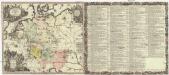
Tabula Novissima Totius Germaniae
1 : 1300000 Mollova mapová sbírka Eisenschmidt, Johann Caspar Homann, Johann Baptista
Reichskreise 1512
Deutschland Reichskreis Kunz, Andreas ; Moeschl, Joachim Robert
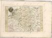
Empire d'Allemagne, divisé en ses dix cercles, ces cercles en leurs principaux estats
1 : 2810000 Evropa střední Sanson, Nicolas Cordier, Louis Pierre Mariette
Deutschland unter den Hohenstaufen, und bis 1275.
1 : 3800000 Spruner von Merz, Karl
Reichskreise 1555
Deutschland Kunz, Andreas ; Moeschl, Joachim Robert
Deutschland unter den saechsischen & fraenkischen Kaisern bis zu den Hohenstaufen.
1 : 3800000 Spruner von Merz, Karl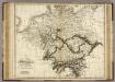
Germany.
1 : 2400000 Playfair, Principal
Neu-vermehrte Post-Charte durch gantz Teutschland nach Italien, Franckreich, Niederland, Preußen, Polen und Ungarn &c.
1 : 2500000 Mollova mapová sbírka Nell, Johann Peter Homann, Johann Baptista
Karte von Deutschland in XVI Blätt
1 : 1000000 nach des H.O.C. Büsching Erdbeschreibung u. den besten Hülfsmitteln entworffen und jetzt nach den neuesten Friedens-Schlüssen gänzlich umgeändert von D.F. Sotzmann J.W. Meil inv. ; C. Jäck sculp. Berlin : In Verlag der K. P. Ac. Kunst- und Buchhandlung von Simon Schropp & Co
[Übersicht der Meteorologischen Stationen in Deutschland, der Schweiz, den Niederlanden]
Erster Band, enthaltend in vier Abtheilungen die Erscheinungen der anorganischen Natur: 1. Meteorologie und Klimatographie. 2. Hydrologie und Hydrographie. 3. Geologie. 4. Tellurischer Magnetismus Humboldt, Alexander von Verlag von Justus Perthes
Societas Iesu Germana Sive Assistentia Germaniae
1 : 2600000 Mollova mapová sbírka Seutter, Matthäus Seutter, Georg Matthäus Seutter, Matthäus
Besondere Post und Reise Carte der Wege Durch Teutschland
1 : 3600000 Mollova mapová sbírka
Tabula Geographica totius S[acri] Imperii Romani
1 : 1800000 Mollova mapová sbírka Müller, Johann Ulrich Bodenehr, Georg Conrad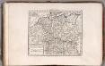
Germania Antiqua.
1 : 4900000 Delamarche, Felix
Germania Secundum
Historia Imperii Romano-Germanici, nec non finitimarum regionum
1 : 2700000 Evropa střední Seutter, Matthäus Matthaeo Seutter