Maps of Germany

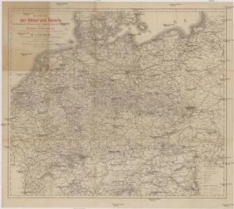
Karte der Bäder und Kurorte Deutschlands, Oesterreich-Ungarns und der Schweiz
1 : 2000000 Německo Liebenow, W. Bäder-Almanach
Karte der Bäder und Kurorte Deutschlands, Oesterreich-Ungarns und der Schweiz
1 : 2000000 Německo Liebenow, W. Bäder-Almanach
Mitteleuropa 1989
Mitteleuropa Kunz, Andreas ; Treiling, Thomas
Post- & Reise- Karte von Deutschland und den nachbar Staaten
1 : 2200000 Evropa střední Kunsch, H. Handtke, F. C. Flemming
Mitteleuropa 1956
Mitteleuropa Kunz, Andreas ; Treiling, Thomas
Mitteleuropa 1990
Mitteleuropa Kunz, Andreas ; Treiling, Thomas
Mitteleuropa 1949
Mitteleuropa Kunz, Andreas ; Treiling, Thomas
Neueste geographische Post und Reise Charte von Deutschland und Preussen
1 : 2320000 Německo Reymann, Gottlob Daniel Berghaus, Heinrich Karl Wilhelm im Magazin für Kunst, Geographie & Musik
Germania Antiqua.
1 : 4900000 Delamarche, Felix

Deutschland, Niederlande, Belgien und Schweiz
Hand-Atlas über alle Theile der Erde nach dem neuesten Zustande und über das Weltgebäude Stieler, Adolf bei Justus Perthes
Mitteleuropa 1993
Mitteleuropa Kunz, Andreas ; Treiling, Thomas
Mitteleuropa 1820
Mitteleuropa Kunz, Andreas ; Moeschl, Joachim Robert
Mitteleuropa 1957
Mitteleuropa Kunz, Andreas ; Treiling, Thomas
Mitteleuropa 1922
Mitteleuropa Kunz, Andreas ; Moeschl, Joachim Robert
Mitteleuropa 1945
Mitteleuropa Kunz, Andreas ; Treiling, Thomas
Mitteleuropa 1937
Mitteleuropa Kunz, Andreas ; Moeschl, Joachim Robert
Deutschland, Übersicht der Politischen Eintheilung
Hand-Atlas über alle Theile der Erde und über das Weltgebäude Stieler, Adolf Justus Perthes
Mitteleuropa 1839
Mitteleuropa Kunz, Andreas ; Moeschl, Joachim Robert
Mitteleuropa 1867
Mitteleuropa Kunz, Andreas ; Moeschl, Joachim Robert
Nationalitäts-Karte Deutschland
1 : 3800000 Mollova mapová sbírka Kiepert, Heinrich
Germaniae Veteris, typus. [Karte], in: Theatrum orbis terrarum, S. 473.
1 Karte aus Atlas Ortelius, Abraham Vrients, Jan Baptista
Germaniae Veteris, typus. [Karte], in: Theatrum orbis terrarum, S. 380.
1 Karte aus Atlas Ortelius, Abraham
Tabula Novissima Totius Germaniae
1 : 1300000 Mollova mapová sbírka Eisenschmidt, Johann Caspar Homann, Johann Baptista
Mitteleuropa 2003
Mitteleuropa Kunz, Andreas ; Treiling, Thomas
Mitteleuropa 1860
Mitteleuropa Kunz, Andreas ; Moeschl, Joachim Robert
Deutschland's Eisenbahnen und Strassen-Netz mit seinen Anschlüssen im Ausland nebst Angabe der wichtigsten Flussdampfschiff-Stationen und Häfen für Seedampfer
1 : 2080000 Evropa střední Gräf, Adolf Hensgen, C. Geographisches Institut
Deutschland nach seinen oro-hydrographischen Verhältnissen
1 : 2570000 Evropa střední Gräf, Adolf Eyb, O. B. Geographisches Institut
Mitteleuropa 1871
Mitteleuropa Kunz, Andreas ; Moeschl, Joachim Robert