Maps of Germany

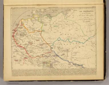
La Germanie 511 a 741.
1 : 6300000 Houze, Antoine Philippe
La Germanie, 275 de J.C.
1 : 6300000 Houze, Antoine Philippe
GERMANIAE | VETERIS | typus.
[Amsterdam : Joan Blaeu]
Nationalitäts-Karte von Deutschland
Německo Kiepert, Heinrich Homann, Johann Baptist Geograph. Institut
Deutschland von 1649 bis 1792.
1 : 3800000 Spruner von Merz, Karl
Post Charte der Östereichis = Teutschen, Preussischen u. Teut. Bund. Staaten...

Germaniae Veteris, typus. [Karte], in: Novus Atlas, das ist, Weltbeschreibung, Bd. 1, S. 291.
1 Karte aus Atlas Blaeu, Joan Blaeu, Willem Janszoon
Mitteleuropa 1949
Mitteleuropa Kunz, Andreas ; Treiling, Thomas
Germaniae Veteris, typus. [Karte], in: Theatrum orbis terrarum, sive, Atlas novus, Bd. 1, S. 316.
1 Karte aus Atlas Blaeu, Joan Blaeu, Willem Janszoon
Mitteleuropa 1812
Mitteleuropa Kunz, Andreas ; Moeschl, Joachim Robert
Germania Augustiniana
1 : 3700000 Mollova mapová sbírka Seutter, Matthäus Seutter, Matthäus
Mitteleuropa 1914
Mitteleuropa Kunz, Andreas ; Moeschl, Joachim Robert
Mitteleuropa 1993
Mitteleuropa Kunz, Andreas ; Treiling, Thomas
Mitteleuropa 1945
Mitteleuropa Kunz, Andreas ; Treiling, Thomas
Mitteleuropa 1922
Mitteleuropa Kunz, Andreas ; Moeschl, Joachim Robert
Germaniae Veteris, typus. [Karte], in: Theatrum orbis terrarum, S. 380.
1 Karte aus Atlas Ortelius, Abraham
Mitteleuropa 1871
Mitteleuropa Kunz, Andreas ; Moeschl, Joachim Robert
Deutschland und benachbarte Länder. Zur Übersicht der Eisenbahnen und Dampfschiffahrten
Hand-Atlas über alle Theile der Erde und über das Weltgebäude Stieler, Adolf Justus Perthes
Deutschland, Niederlande, Belgien und Schweiz
Hand-Atlas über alle Theile der Erde nach dem neuesten Zustande und über das Weltgebäude Stieler, Adolf bei Justus Perthes
Germany.
1 : 5200000 Darton, William
Germania [Karte], in: Gerardi Mercatoris Atlas, sive, Cosmographicae meditationes de fabrica mundi et fabricati figura, S. 327.
1 Karte aus Atlas Mercator, Gerhard Montanus, Petrus
Mitteleuropa 1956
Mitteleuropa Kunz, Andreas ; Treiling, Thomas
[Deutschland, Niederlande, Belgien und Schweiz; National-, Sprach-, Dialect- Verschiedenheit]
Zweiter Band, enthaltend in vier Abtheilungen die Vertheilung der Organismen: 5. Pflanzen-Geographie, 6. Thier-Geographie, 7. Anthropographie, 8. Ethnographie Humboldt, Alexander von Verlag von Justus Perthes
Germany, Austria, Bohemia.
1 : 2600000 Cary, John, ca. 1754-1835
Mitteleuropa 2003
Mitteleuropa Kunz, Andreas ; Treiling, Thomas
Mitteleuropa 1990
Mitteleuropa Kunz, Andreas ; Treiling, Thomas
Post Karte von Deutschland und den angraenzenden Laendern vorzüglich der preussischen Staaten
1 : 1700000 Evropa střední Mollo, Tranquillo T. Mollo
Germaniae Veteris, typus. [Karte], in: Le théâtre du monde, ou, Nouvel atlas contenant les chartes et descriptions de tous les païs de la terre, Bd. 1, S. 320.
1 Karte aus Atlas Blaeu, Willem Janszoon und Blaeu, Joan Blaeu, Willem Janszoon
Mitteleuropa 1989
Mitteleuropa Kunz, Andreas ; Treiling, Thomas