Maps of Germany

Deutschland.
1 : 3400000 Radefeld, Carl Christian Franz, 1788-1874
Norddeutsche Bundesstaaten, Süddeutsche Bundesstaaten
Evropa střední
Neuste Post Karte von Deutschland und dessen angrenzenden Laender
Evropa střední Walch, Johann bey Ioh. Walch
Deutschland.
1 : 2400000 Ziegler, J. M.
Tableau l'historie de la Confederation Germanique.
1 : 6200000 Duval, Henri
Deutschland
1 : 2350000 Evropa střední Weiland, Karl Ferdinand Geographisches Institut
Deutschland
1 : 2350000 Evropa střední Weiland, Karl Ferdinand Geographisches Institut
Deutschland
1 : 2350000 Evropa střední Weiland, Karl Ferdinand Geographisches Institut
Confederation Germanique.
1 : 4000000 Malte-Brun, Conrad, 1775-1826
Nova totius Germaniae descriptio
1 : 3640000 Evropa střední Hofmann, Johann Johann Hofman[n]
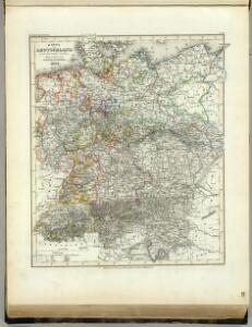
Deutschland.
1 : 4800000 Reichard, C. G.
Deutschland.
1 : 2300000 Weiland, C. F. (Carl Ferdinand), d. 1847
Germany.
1 : 9000000 Fenner, Rest.
Deutschland
1 : 2350000 Evropa střední Weiland, Karl Ferdinand Geographisches Institut
Deutschland's Eisenbahnen und Strassen-Netz mit seinen Anschlüssen im Ausland nebst Angabe der wichtigsten Flussdampfschiff-Stationen und Häfen für Seedampfer
1 : 2080000 Evropa střední Gräf, Adolf Hensgen, C. Geographisches Institut
Deutschland nach seinen oro-hydrographischen Verhältnissen
1 : 2570000 Evropa střední Gräf, Adolf Eyb, O. B. Geographisches Institut
Dějiště války třicetileté po míru vestfálském

Germania magna ausser der Cimbrischen Halbinsel
Německo Kruse, Friedrich Leidenfrost, E. in Ernst Kleins literarischem und geographishem Comptoir
Composite: Carte Generale des Etats composant La Confederation Germanique.
1 : 2750000 Vivien de St Martin, L.
Deutschland
Geographischer Atlas über alle Theile der Erde Ziegler, Jakob Melchior Verlag von Dietrich Reimer
Germany.
1 : 3170000 Mitchell, Samuel Augustus
Germany.
1 : 3170000 Mitchell, Samuel Augustus
Karte der Bäder und Kurorte Deutschlands, Oesterreich-Ungarns und der Schweiz
1 : 2000000 Německo Liebenow, W. Bäder-Almanach
Karte der Bäder und Kurorte Deutschlands, Oesterreich-Ungarns und der Schweiz
1 : 2000000 Německo Liebenow, W. Bäder-Almanach
Karte von Deutschland
Grosser Hand-Atlas über alle Theile der Erde in 170 Karten Meyer, J. Verlag des Bibliographischen Instituts
Germany.
1 : 3170000 Tanner, Henry S.
Deutschland unter den saechsischen & fraenkischen Kaisern bis zu den Hohenstaufen.
1 : 3800000 Spruner von Merz, Karl
Neueste Karte von Deutschland und den angränzenden Ländern
Evropa střední Schmidt, Johann Marius Friedrich Schropp, Simon Simon Schropp & C.
[Deutschland, Niederlande, Königreich Belgien und Schweiz]
Schul-Atlas über alle Theile der Erde nach dem neuesten Zustande, und über das Weltgebäude Stieler, Adolf bei Justus Perthes
Germany.
1 : 3674880 Johnson, A.J.