Maps of Massachusetts

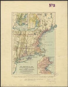
The colonies in 1660, New England and New Netherland showing extent and dates of settlement
1 : 3000000 Myers, Albert Cook Burrows Brothers Company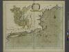
A large draught of New England, New York and Long Island.
from The sea-atlas : containing an hydrographical description of most of the sea-coasts of the known parts of the world.
Railway map New England States.
1 : 1175000 George K. Snow & Bradlee
Railway map New England States.
1 : 1175000 George K. Snow & Bradlee
Sketch of the states of Massachusetts, Connecticut, and Rhode Island, and parts of New Hampshire & New York exhibiting the several rail road routes completed, constructing, chartered & contemplated : published by order of the Legislature of Massachusetts
1 : 700000 Kennedy, Archibald, fl. 1850 [s.n.]
Railroad map of New England & eastern New York : compiled from the most authentic sources
1 : 700000 Goldthwait, J. H Redding & Co. ; Clark, Austin & Co.
Carte de la Nouvelle Angleterre: New York, Pensilvanie et Nouveau Jersay suivant les cartes angloises.
from John H. Levine Collection Bellin: [Paris]; Bellin, Jacques Nicolas,
Eastern States.
1 : 2400000 D.F. Robinson & Co.
Map of New England exhibiting the rail and telegraphic lines now in operation
Brown & Hastings Coolidge & Wiley
New England, Eastern New York.
1 : 805000 Rand McNally and Company
The north eastern coast, North America, New York to Cape Canso (west sheet)
1 : 910000 Wadsworth, A. S. (Alex. S.)
A map of Massachusetts, Connecticut and Rhodeisland
1 : 424000 Ruggles, Edward, fl. 1789-1817 [s.n.]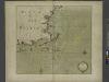
Part of NEW ENGLAND
from The sea-atlas : containing an hydrographical description of most of the sea-coasts of the known parts of the world.
New England States.
1 : 520000 Hale, Nathan
Vermont, Massachusetts, Rhode Island, and Connecticut.
1 : 4384000 Fisher, Richard Swainson
Map of the New York & Boston Railway : with its connections with other railways
Swett and Powers (Firm) Swett & Powers
Map of Massachusetts, Connecticut and Rhode Island : constructed from the latest authorities
1 : 700000 Vance, D. H. (David H.) A. Finley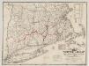
The "centennial" postal statistical map of Massachusetts, Rhode Island and Connecticut : showing railroads, post routes and offices together with population and valuation of cities and towns
1 : 422400 Cook and Ellis (Firm) M.G. Cook and Frank O. Ellis
New Hampshire, Vermont, Massachusetts, Rhode Island, and Connecticut.
1 : 1270000 Asher & Adams
N.Y., Vt., Maine, N.H., Mass., Conn., R.I., N.J.
1 : 1770000 Society for the Diffusion of Useful Knowledge (Great Britain)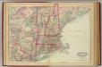
N.H., Vt., Mass., R.I., Conn.
1 : 1267200 Asher & Adams
New England States.
1 : 520000 Hale, Nathan
A Map of the New England States.
1 : 520000 Hale, Nathan
Map of the Sherbrooke, Eastern Townships and Kennebec Railway : with connections
1 : 1267200 G.W. & C.B. Colton & Co G.W. & C.B. Colton & Co.
Telegraph and rail road map of the New England states

Williams' telegraph and rail road map of the New England states, eastern portion of New York state and Canada

To the honourable Walter Younge, barronet, one of the commissioners for his majestie's collonis : this description of New England in America is most humbly dedicated & presented by your hombl., faithfull & obedient servt
1 : 2200000 Hacke, William
The New England commercial and route survey

New England and New York in 1697
Charts of the coast and harbors of New England : from surveys taken by Saml. Holland Esqr. Survr. Genr. of Lands for the Northern District of North America and Geo. Sproule, Chas. Blaskowitz, Jam.s Grant and Thos. Wheeler his assistants : Coast of Charleston, South Carolina
Des Barres, Joseph F. W. (Joseph Frederick Wallet), 1722-1824 J.F.W. Des Barres
Charts of the coast and harbors of New England : from surveys taken by Saml. Holland Esqr. Survr. Genr. of Lands for the Northern District of North America and Geo. Sproule, Chas. Blaskowitz, Jam.s Grant and Thos. Wheeler his assistants : Portions of the Hudson River
Des Barres, Joseph F. W. (Joseph Frederick Wallet), 1722-1824 J.F.W. Des Barres
Charts of the coast and harbors of New England : from surveys taken by Saml. Holland Esqr. Survr. Genr. of Lands for the Northern District of North America and Geo. Sproule, Chas. Blaskowitz, Jam.s Grant and Thos. Wheeler his assistants : Portion of the Virginia Coast
Des Barres, Joseph F. W. (Joseph Frederick Wallet), 1722-1824 J.F.W. Des Barres
Charts of the coast and harbors of New England : from surveys taken by Saml. Holland Esqr. Survr. Genr. of Lands for the Northern District of North America and Geo. Sproule, Chas. Blaskowitz, Jam.s Grant and Thos. Wheeler his assistants : Harbor of Rhode Island and Narragansett Bay
Des Barres, Joseph F. W. (Joseph Frederick Wallet), 1722-1824 J.F.W. Des Barres
Charts of the coast and harbors of New England : from surveys taken by Saml. Holland Esqr. Survr. Genr. of Lands for the Northern District of North America and Geo. Sproule, Chas. Blaskowitz, Jam.s Grant and Thos. Wheeler his assistants : Charleston Harbor, South Carolina
Des Barres, Joseph F. W. (Joseph Frederick Wallet), 1722-1824 J.F.W. Des Barres
Charts of the coast and harbors of New England : from surveys taken by Saml. Holland Esqr. Survr. Genr. of Lands for the Northern District of North America and Geo. Sproule, Chas. Blaskowitz, Jam.s Grant and Thos. Wheeler his assistants : Hudson River
Des Barres, Joseph F. W. (Joseph Frederick Wallet), 1722-1824 J.F.W. Des Barres
Charts of the coast and harbors of New England : from surveys taken by Saml. Holland Esqr. Survr. Genr. of Lands for the Northern District of North America and Geo. Sproule, Chas. Blaskowitz, Jam.s Grant and Thos. Wheeler his assistants : Delaware River
Des Barres, Joseph F. W. (Joseph Frederick Wallet), 1722-1824 J.F.W. Des Barres