Maps of Maine

New England States.
1 : 520000 Hale, Nathan
Map New England

New England.
1 : 1550000 Walling, H. F.
Parcel post map of the United States
1 : 7800000 L.L. Poates Engr'g Co. L.L. Poates Engr'g Co.
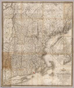
Map of New England with adjacent portions of New York & Canada
1 : 1537500 Walling, Henry Francis Walling, Henry Francis
G. Woolworth Colton's railroad, township & distance map of New England with adjacent portions of New York, Canada & New Brunswick
1 : 900000 Colton, G. Woolworth Colton, G. Woolworth
Map of New England with adjacent portions of New York & Canada
1 : 1537500 Walling, Henry Francis Walling, Henry Francis
The New England states and part of Canada

New England.
1 : 2100000 Mitchell, Samuel Augustus
[Map of New England, 31st]

New England States.
1 : 520000 Hale, Nathan
Map of New England, with adjacent portions of New York & Canada
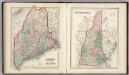
Maine. New Hampshire.
1 : 1250000 Gray, Ormando Willis
A map of the New England states : Maine, New Hampshire, Vermont, Massachusetts, Rhode Island & Connecticut, with the adjacent parts of New York & lower Canada
1 : 506880 Hale, Nathan, 1784-1863 Nathan Hale
Railway map New England States.
1 : 1175000 George K. Snow & Bradlee
Railway map New England States.
1 : 1175000 George K. Snow & Bradlee
New England And Lower Canada.
1 : 1520640 Johnson, A.J.
Map of New England exhibiting the rail and telegraphic lines now in operation
Brown & Hastings Coolidge & Wiley
Boston Clinton Fitchburg and Mansfield Framingham Lowell Railroads, and connections
1 : 2700000 American Bank Note Company
Eastern States.
1 : 2400000 D.F. Robinson & Co.
Telegraph and rail road map of the New England states

Williams' telegraph and rail road map of the New England states, eastern portion of New York state and Canada

Maine, New Hampshire, Vermont, Massachusetts, Connecticut & Rhode Island.
1 : 1140480 Tanner, Henry S.
Map Of The States Of Maine, New Hampshire, Vermont, Massachusetts, Connecticut & Rhode Island.
1 : 1140480 Tanner, Henry S.
Maine, New Hampshire, Vermont, Massachusetts, Connecticut & Rhode Island.
1 : 1140480 Tanner, Henry S.
Maine, New Hampshire, Vermont, Massachusetts, Connecticut & Rhode Island.
1 : 1140480 Tanner, Henry S.
Maine, New Hampshire, Vermont, Massachusetts, Connecticut & Rhode Island.
1 : 1140480 Tanner, Henry S.
Nova Anglia Septentrionali Americae implantata Anglorumque coloniis florentissima / geographice exhibita â Ioh. Baptista Homann, sac. caes. maj. geographo.
from John H. Levine Collection John Baptista Homann, S.,
New England.
1 : 2700000 Cornell, S. S. (Sarah S.)