Maps of Massachusetts

N.Y., Vt., Maine, N.H., Mass., Conn., R.I., N.J.
1 : 1770000 Society for the Diffusion of Useful Knowledge (Great Britain)
Carte de la Nouvelle Angleterre: New York, Pensilvanie et Nouveau Jersay suivant les cartes angloises.
from John H. Levine Collection Bellin: [Paris]; Bellin, Jacques Nicolas,
E. United States 2.
1 : 1774080 Letts, Son & Co.
New England.
from A new systeme of the mathematicks: containing I. Arithmetick, as well natural and decimal, as in species, or the principles of algebra. II. Practical geometry, together with the first six books of Euclid's Elements, as also the eleventh and twelfth, symbo
Carte du theatre de la guerre entre les Anglais et les Américains; dressée d'aprés les cartes anglaises les plus modernes / par M. Brion de la Tour, ingénieur-géographe du roi.
from Revolutionary War, 1775-1783 M. Bellin,
Mappa geographica Provinciae Novae Eboraci ab Anglis New-York dictae / ex ampliori delineatione ad exactas dimensiones concinnata in arctius spatium redacta cura Claudii Josephi Sauthier cui accedit Nova Jersey ex topographicis observationibus.
from Charts and maps Claude Joseph Sauthier,
Railroad map of New England & eastern New York : compiled from the most authentic sources
1 : 700000 Goldthwait, J. H Redding & Co. ; Clark, Austin & Co.
A new and accurate map of New Jersey, Pensilvania, New York and New England: with the adjacent countries / drawn from surveys, assisted by the most approved modern maps & charts and regulated by astronomical observations by Eman. Bowen.
from Charts and maps Emannuel Bowen,
New Engelland, New York, New Yersey und Pensilvania

The north eastern part of the United States / drawn and engraved by W. Hughes.
from Parts W. Hughes.,
An exact map of New England, New York, Pensylvania & New Jersey, from the latest surveys / J. Lodge, sculp.
from Parts
Carte du théatre de la guerre entre les Anglais et les Américains

Carte du théatre de la guerre entre les Angais et les Américans
A large draught of New England, New York and Long Island.
from The sea-atlas : containing an hydrographical description of most of the sea-coasts of the known parts of the world.
Karte von Neu England, Neu Yorck und Pensilvanien

Carte du théatre de la guerre entre les Anglais et les Américains
1 : 1400000 Nová Anglie Brion de la Tour, Louis Esnauts et Rapilly
Map Central Vt. RR.
1 : 3509000 Central Vermont Railroad Company
Carte du théatre de la guerre entre les Anglais et les Américains dressée d'après les cartes anglaises les plus modernes, / par M. Brion de la Tour, ingr. géographe du Roi.
from Charts and maps M. Bellin,
Carte du théatre de la guerre entre les Anglais et les Américains: dressée d'après les cartes anglaises les plus modernes / par M. Brion de la Tour, ingénieur-geógraphe du Roi.
from Charts and maps M. Bellin,
Sketch of the states of Massachusetts, Connecticut, and Rhode Island, and parts of New Hampshire & New York exhibiting the several rail road routes completed, constructing, chartered & contemplated : published by order of the Legislature of Massachusetts
1 : 700000 Kennedy, Archibald, fl. 1850 [s.n.]
Pensylvania Nova Jersey et Nova York cum regionibus ad fluvium Delaware in America sitis, nova delineatione ob oculos posita
1 : 2200000 New Jersey Lotter, Tobias Conrad per Tob. Conr. Lotter
Scene of Operations of the Northern Army.
1 : 1950000 Marshall, John
Rome, Watertown and Ogdensburg Railroad.
1 : 5514850 Rome, Watertown & Ogdensburg Railroad Company
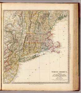
Massachusetts, Rhode Island, and Connecticut. New York.
1 : 1000000 Schonberg & Co.
Nova Belgica Et Anglia Nova [Karte], in: Theatrum orbis terrarum, sive, Atlas novus, Bd. 2, S. 319.
1 Karte aus Atlas Blaeu, Joan Blaeu, Willem Janszoon
A map of Massachusetts, Connecticut and Rhodeisland
1 : 424000 Ruggles, Edward, fl. 1789-1817 [s.n.]
Bridge by which the South Mountain & Boston R.R. is to cross the Hudson River at Poughkeepsie, N.Y. ; The Map of South Mountain and Boston
from New illustrated atlas of Dutchess County, New York. / Compiled & drawn from personal examinations, surveys etc. under the personal supervision of O.W. Gray & Son and F.A. Davis, and published under the superintendence of H. L. Kochersperger.
Nova Anglia Septentrionali Americae implantata Anglorumque coloniis florentissima / geographice exhibita â Ioh. Baptista Homann, sac. caes. maj. geographo.
from John H. Levine Collection John Baptista Homann, S.,
Map of Massachusetts, Connecticut and Rhode Island : constructed from the latest authorities
1 : 700000 Vance, D. H. (David H.) A. Finley