Maps of Massachusetts

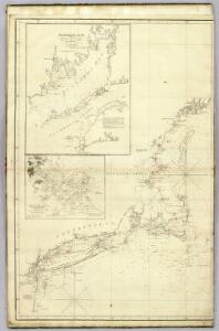
The north eastern coast, North America, New York to Cape Canso (west sheet)
1 : 910000 Wadsworth, A. S. (Alex. S.)
Vermont, Massachusetts, Rhode Island, and Connecticut.
1 : 4384000 Fisher, Richard Swainson
N.Y., Vt., Maine, N.H., Mass., Conn., R.I., N.J.
1 : 1770000 Society for the Diffusion of Useful Knowledge (Great Britain)
Map of the Sherbrooke, Eastern Townships and Kennebec Railway : with connections
1 : 1267200 G.W. & C.B. Colton & Co G.W. & C.B. Colton & Co.
Railway map New England States.
1 : 1175000 George K. Snow & Bradlee
Railway map New England States.
1 : 1175000 George K. Snow & Bradlee
Mappa geographica Provinciae Novae Eboraci ab Anglis New-York dictae / ex ampliori delineatione ad exactas dimensiones concinnata in arctius spatium redacta cura Claudii Josephi Sauthier cui accedit Nova Jersey ex topographicis observationibus.
from Charts and maps Claude Joseph Sauthier,
New England, Eastern New York.
1 : 805000 Rand McNally and Company
The colonies in 1660, New England and New Netherland showing extent and dates of settlement
1 : 3000000 Myers, Albert Cook Burrows Brothers Company
Post route map of the states of New Hampshire, Vermont, Massachusetts, Rhode Island, Connecticut, and parts of New York and Maine
1 : 380160 Nicholson, W. L. United States. Post Office Dept.
Vermont, New Hampshire, Massachusetts, Rhode Island, and Connecticut.
1 : 1077000 Johnson, A.J.
199. New England. The World Atlas.
1 : 125000 USSR (Union of Soviet Socialist Republics).
New England States.
1 : 520000 Hale, Nathan
Post route map of the states of New Hampshire, Vermont, Massachusetts, Rhode Island, Connecticut, and parts of New York and Maine
1 : 380160 Nicholson, Walter L. United States. Post Office Dept.
Eastern States.
1 : 2400000 D.F. Robinson & Co.
Sketch of the states of Massachusetts, Connecticut, and Rhode Island, and parts of New Hampshire & New York exhibiting the several rail road routes completed, constructing, chartered & contemplated : published by order of the Legislature of Massachusetts
1 : 700000 Kennedy, Archibald, fl. 1850 [s.n.]
Map of New England exhibiting the rail and telegraphic lines now in operation
Brown & Hastings Coolidge & Wiley
A Map of the New England States.
1 : 520000 Hale, Nathan
A map of Massachusetts, Connecticut and Rhodeisland
1 : 424000 Ruggles, Edward, fl. 1789-1817 [s.n.]
Map of the New York & Boston Railway : with its connections with other railways
Swett and Powers (Firm) Swett & Powers
Travel-map of New England
1 : 304000 Guyde Publishing Company
New Hampshire, Vermont, Massachusetts, Rhode Island, and Connecticut.
1 : 1270000 Asher & Adams
The "centennial" postal statistical map of Massachusetts, Rhode Island and Connecticut : showing railroads, post routes and offices together with population and valuation of cities and towns
1 : 422400 Cook and Ellis (Firm) M.G. Cook and Frank O. Ellis
New England States.
1 : 520000 Hale, Nathan
Map of Massachusetts, Connecticut and Rhode Island : constructed from the latest authorities
1 : 700000 Vance, D. H. (David H.) A. Finley
Massachusetts and Rhode Island.
from The cerographic atlas of the United States. By Sidney E. Morse, A.M., and Samuel Breese, A.M.
New York, New Jersey, Massachusetts, Connecticut, Rhode Island.
1 : 1584000 Smith, J. Calvin
The New England commercial and route survey

Boston Clinton Fitchburg and Mansfield Framingham Lowell Railroads, and connections
1 : 2700000 American Bank Note Company