Maps of Massachusetts

To the honourable Walter Younge, barronet, one of the commissioners for his majestie's collonis : this description of New England in America is most humbly dedicated & presented by your hombl., faithfull & obedient servt
1 : 2200000 Hacke, William
New England and New York in 1697

Map of the New York & Boston Railway : with its connections with other railways
Swett and Powers (Firm) Swett & Powers
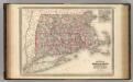
A map of Massachusetts, Connecticut and Rhodeisland
1 : 424000 Ruggles, Edward, fl. 1789-1817 [s.n.]
A map of the most inhabited part of New England containing the provinces of Massachusets Bay and New Hampshire with the colonies of Connecticut and Rhode Island divided into counties and townships the w[h]ole composed from actual surveys ...

A map of the most inhabited part of New England, containing the provinces of Massachusets Bay and New Hampshire, with the colonies of Connecticut and Rhode Island, divided into counties and townships, the whole composed from actual surveys ...

Vermont, Massachusetts, Rhode Island, and Connecticut.
1 : 4384000 Fisher, Richard Swainson
Map of Massachusetts, Connecticut and Rhode Island : constructed from the latest authorities
1 : 700000 Vance, D. H. (David H.) A. Finley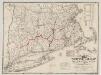
The "centennial" postal statistical map of Massachusetts, Rhode Island and Connecticut : showing railroads, post routes and offices together with population and valuation of cities and towns
1 : 422400 Cook and Ellis (Firm) M.G. Cook and Frank O. Ellis
The colonies in 1660, New England and New Netherland showing extent and dates of settlement
1 : 3000000 Myers, Albert Cook Burrows Brothers Company
New England, Eastern New York.
1 : 805000 Rand McNally and Company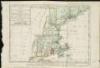
Carte de la Nouvelle Angleterre, comprenant les etats de Massachusets Bay, N. Hamp Shire, Connecticut et Rhode Island

A Map of the New England States.
1 : 520000 Hale, Nathan
Railroad Map Featuring Many Northeastern States Rhode Island Connecticut Massachusetts
1 : 2000
The north eastern coast, North America, New York to Cape Canso (west sheet)
1 : 910000 Wadsworth, A. S. (Alex. S.)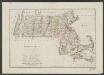
Massachusetts
1 : 490000 Sotzmann, D. F Bey Carl Ernst Bohn
The New England commercial and route survey

Post route map of the states of New Hampshire, Vermont, Massachusetts, Rhode Island, Connecticut, and parts of New York and Maine
1 : 380160 Nicholson, W. L. United States. Post Office Dept.
County map of Massachusetts, Connecticut, and Rhode Island.
from New general atlas.
Vermont, New Hampshire, Massachusetts, Rhode Island, and Connecticut.
1 : 1077000 Johnson, A.J.
199. New England. The World Atlas.
1 : 125000 USSR (Union of Soviet Socialist Republics).
Travel-map of New England
1 : 304000 Guyde Publishing Company
Post route map of the states of New Hampshire, Vermont, Massachusetts, Rhode Island, Connecticut, and parts of New York and Maine
1 : 380160 Nicholson, Walter L. United States. Post Office Dept.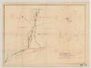
[Map of railroad lines from New York to Springfield, Mass.]
J.H. Bufford & Co Bufford & Co. Lith.
New York, New Jersey, Massachusetts, Connecticut, Rhode Island.
1 : 1584000 Smith, J. Calvin
Massachusetts and Rhode Island.
from The cerographic atlas of the United States. By Sidney E. Morse, A.M., and Samuel Breese, A.M.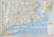
Shell Highway Map of Massachusetts, Connecticut, Rhode Island.
1 : 570240 Shell Oil Company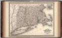
Massachusetts, Connecticut, and Rhode Island.
1 : 660000 Johnson, A.J.
Massachusetts, Connecticut, Rhode Island.
1 : 688000 Finley, Anthony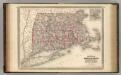
Massachusetts, Connecticut, and Rhode Island.
1 : 660000 Johnson, A.J.