Maps of Massachusetts

Sketch of the states of Massachusetts, Connecticut, and Rhode Island, and parts of New Hampshire & New York exhibiting the several rail road routes completed, constructing, chartered & contemplated : published by order of the Legislature of Massachusetts
1 : 700000 Kennedy, Archibald, fl. 1850 [s.n.]
A large draught of New England, New York and Long Island.
from The sea-atlas : containing an hydrographical description of most of the sea-coasts of the known parts of the world.
Railroad map of New England & eastern New York : compiled from the most authentic sources
1 : 700000 Goldthwait, J. H Redding & Co. ; Clark, Austin & Co.
Carte de la Nouvelle Angleterre: New York, Pensilvanie et Nouveau Jersay suivant les cartes angloises.
from John H. Levine Collection Bellin: [Paris]; Bellin, Jacques Nicolas,
A map of Massachusetts, Connecticut and Rhodeisland
1 : 424000 Ruggles, Edward, fl. 1789-1817 [s.n.]
An exact map of New England, New York, Pensylvania & New Jersey, from the latest surveys / J. Lodge, sculp.
from Parts
E. United States 2.
1 : 1774080 Letts, Son & Co.
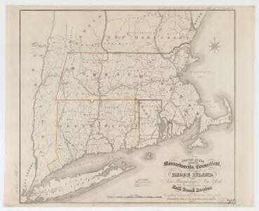
Map of Massachusetts, Connecticut and Rhode Island : constructed from the latest authorities
1 : 700000 Vance, D. H. (David H.) A. Finley
New England.
from A new systeme of the mathematicks: containing I. Arithmetick, as well natural and decimal, as in species, or the principles of algebra. II. Practical geometry, together with the first six books of Euclid's Elements, as also the eleventh and twelfth, symbo
N.Y., Vt., Maine, N.H., Mass., Conn., R.I., N.J.
1 : 1770000 Society for the Diffusion of Useful Knowledge (Great Britain)
Carte du théatre de la guerre entre les Anglais et les Américains
1 : 1400000 Nová Anglie Brion de la Tour, Louis Esnauts et Rapilly
The colonies in 1660, New England and New Netherland showing extent and dates of settlement
1 : 3000000 Myers, Albert Cook Burrows Brothers Company
The "centennial" postal statistical map of Massachusetts, Rhode Island and Connecticut : showing railroads, post routes and offices together with population and valuation of cities and towns
1 : 422400 Cook and Ellis (Firm) M.G. Cook and Frank O. Ellis
Map of the New York & Boston Railway : with its connections with other railways
Swett and Powers (Firm) Swett & Powers
Railway map New England States.
1 : 1175000 George K. Snow & Bradlee
Railway map New England States.
1 : 1175000 George K. Snow & Bradlee
Mappa geographica Provinciae Novae Eboraci ab Anglis New-York dictae / ex ampliori delineatione ad exactas dimensiones concinnata in arctius spatium redacta cura Claudii Josephi Sauthier cui accedit Nova Jersey ex topographicis observationibus.
from Charts and maps Claude Joseph Sauthier,
Pensylvania Nova Jersey et Nova York cum regionibus ad fluvium Delaware in America sitis, nova delineatione ob oculos posita
1 : 2200000 New Jersey Lotter, Tobias Conrad per Tob. Conr. Lotter
New Hampshire, Vermont, Massachusetts, Rhode Island, and Connecticut.
1 : 1270000 Asher & Adams
N.H., Vt., Mass., R.I., Conn.
1 : 1267200 Asher & Adams
Map of New England exhibiting the rail and telegraphic lines now in operation
Brown & Hastings Coolidge & Wiley
The north eastern coast, North America, New York to Cape Canso (west sheet)
1 : 910000 Wadsworth, A. S. (Alex. S.)
Bridge by which the South Mountain & Boston R.R. is to cross the Hudson River at Poughkeepsie, N.Y. ; The Map of South Mountain and Boston
from New illustrated atlas of Dutchess County, New York. / Compiled & drawn from personal examinations, surveys etc. under the personal supervision of O.W. Gray & Son and F.A. Davis, and published under the superintendence of H. L. Kochersperger.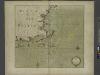
Part of NEW ENGLAND
from The sea-atlas : containing an hydrographical description of most of the sea-coasts of the known parts of the world.
Vermont, Massachusetts, Rhode Island, and Connecticut.
1 : 4384000 Fisher, Richard Swainson
New York, New Jersey, Massachusetts, Connecticut, Rhode Island.
1 : 1584000 Smith, J. Calvin
Map Central Vt. RR.
1 : 3509000 Central Vermont Railroad Company
Carte du théatre de la guerre entre les Anglais et les Américains dressée d'après les cartes anglaises les plus modernes, / par M. Brion de la Tour, ingr. géographe du Roi.
from Charts and maps M. Bellin,
Carte du théatre de la guerre entre les Anglais et les Américains: dressée d'après les cartes anglaises les plus modernes / par M. Brion de la Tour, ingénieur-geógraphe du Roi.
from Charts and maps M. Bellin,