Maps of Massachusetts

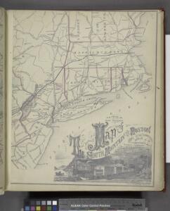
Bridge by which the South Mountain & Boston R.R. is to cross the Hudson River at Poughkeepsie, N.Y. ; The Map of South Mountain and Boston
from New illustrated atlas of Dutchess County, New York. / Compiled & drawn from personal examinations, surveys etc. under the personal supervision of O.W. Gray & Son and F.A. Davis, and published under the superintendence of H. L. Kochersperger.
Novi Belgii Novaeque Angliae nec non partis Virginiae tabula
1 : 5500000 Visscher, Nicolaes Burrows Brothers Company
Recens edita totius Novi Belgii in America septentrionali siti
1 : 2300000 New York (stát) Seutter, Matthäus Matthäus Seutter
Recens edita totius Novi Belgii in America septentrionali siti, delineatio
1 : 2300000 New York (stát) Seutter, Matthäus sumtibus Matthaei Seutteri
E. United States 2.
1 : 1774080 Letts, Son & Co.
A map of the provinces of New-York and New Jersey : with a part of Pennsylvania and the Province of Quebec / from the topographical observations of C. J. Sauthier ; engraved and published by Matthew Albert Lotter.
from Charts and maps
Kaart van Nieuw Nederland : behoorende tot de, door het Provinciaal Utrechtsch Genootschap bekroonde Verhandeling van R.G. Bennet en J. van Wyk, Rz.
1 : 1250000 Te Dordrecht : bij J. de Vos & Ci.
Kaart van Nieuw Nederland / [getekend door] R. van Wijk
Dordrecht : J. de Vos
Pensylvania Nova Jersey et Nova York cum regionibus ad fluvium Delaware in America sitis, nova delineatione ob oculos posita
1 : 2200000 New Jersey Lotter, Tobias Conrad per Tob. Conr. Lotter
132-33. Mass., Conn., R.I., N.J., Del., Md.
1 : 1500000 Touring club italiano
Nova Belgica Et Anglia Nova [Karte], in: Theatrum orbis terrarum, sive, Atlas novus, Bd. 2, S. 319.
1 Karte aus Atlas Blaeu, Joan Blaeu, Willem Janszoon
N.Y., Vt., Maine, N.H., Mass., Conn., R.I., N.J.
1 : 1770000 Society for the Diffusion of Useful Knowledge (Great Britain)
Pensylvania Nova Jersey et Nova York cum Regionibus ad Fluvium Delaware in America sitis
1 : 1000000 Lotter, Tobias Conrad
New England.
from A new systeme of the mathematicks: containing I. Arithmetick, as well natural and decimal, as in species, or the principles of algebra. II. Practical geometry, together with the first six books of Euclid's Elements, as also the eleventh and twelfth, symbo
A map of the provinces of New-York and New-Jersey, with a part of Pennsylvania and the province of Quebec
1 : 1025000 New Jersey Lotter, Matthäus Albrecht Matthew Albert Lotter
Special -Karte der Vereinigten Staaten von Nord - America No 8.

Mappa geographica Provinciae Novae Eboraci ab Anglis New-York dictae / ex ampliori delineatione ad exactas dimensiones concinnata in arctius spatium redacta cura Claudii Josephi Sauthier cui accedit Nova Jersey ex topographicis observationibus.
from Charts and maps Claude Joseph Sauthier,
Carte de la Nouvelle Angleterre: New York, Pensilvanie et Nouveau Jersay suivant les cartes angloises.
from John H. Levine Collection Bellin: [Paris]; Bellin, Jacques Nicolas,
Carte du théatre de la guerre entre les Anglais et les Américains

Carte du théatre de la guerre entre les Angais et les Américans

Map of Massachusetts, Connecticut and Rhode Island : constructed from the latest authorities
1 : 700000 Vance, D. H. (David H.) A. Finley
A map of Massachusetts, Connecticut and Rhodeisland
1 : 424000 Ruggles, Edward, fl. 1789-1817 [s.n.]
Map of the Seat of War: Map showing the railroad routes
Map of the Seat of War: Map showing the railroad routes L. Prang & Co.
The "centennial" postal statistical map of Massachusetts, Rhode Island and Connecticut : showing railroads, post routes and offices together with population and valuation of cities and towns
1 : 422400 Cook and Ellis (Firm) M.G. Cook and Frank O. Ellis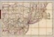
(Penn., N.Y., New England) Railroad Map of the United States.
1 : 506880 Rand McNally and Company
Sketch of the states of Massachusetts, Connecticut, and Rhode Island, and parts of New Hampshire & New York exhibiting the several rail road routes completed, constructing, chartered & contemplated : published by order of the Legislature of Massachusetts
1 : 700000 Kennedy, Archibald, fl. 1850 [s.n.]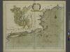
A large draught of New England, New York and Long Island.
from The sea-atlas : containing an hydrographical description of most of the sea-coasts of the known parts of the world.
Railroad map of New England & eastern New York : compiled from the most authentic sources
1 : 700000 Goldthwait, J. H Redding & Co. ; Clark, Austin & Co.
Map Central Vt. RR.
1 : 3509000 Central Vermont Railroad Company
Carte du théatre de la guerre entre les Anglais et les Américains dressée d'après les cartes anglaises les plus modernes, / par M. Brion de la Tour, ingr. géographe du Roi.
from Charts and maps M. Bellin,