Maps of Massachusetts

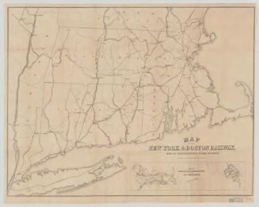
Map of the New York & Boston Railway : with its connections with other railways
Swett and Powers (Firm) Swett & Powers
The "centennial" postal statistical map of Massachusetts, Rhode Island and Connecticut : showing railroads, post routes and offices together with population and valuation of cities and towns
1 : 422400 Cook and Ellis (Firm) M.G. Cook and Frank O. Ellis
Map of Massachusetts, Connecticut and Rhode Island : constructed from the latest authorities
1 : 700000 Vance, D. H. (David H.) A. Finley
A map of Massachusetts, Connecticut and Rhodeisland
1 : 424000 Ruggles, Edward, fl. 1789-1817 [s.n.]
Sketch of the states of Massachusetts, Connecticut, and Rhode Island, and parts of New Hampshire & New York exhibiting the several rail road routes completed, constructing, chartered & contemplated : published by order of the Legislature of Massachusetts
1 : 700000 Kennedy, Archibald, fl. 1850 [s.n.]
N.Y., Vt., Maine, N.H., Mass., Conn., R.I., N.J.
1 : 1770000 Society for the Diffusion of Useful Knowledge (Great Britain)
The colonies in 1660, New England and New Netherland showing extent and dates of settlement
1 : 3000000 Myers, Albert Cook Burrows Brothers Company
New England and New York in 1697

New York, New Jersey, Massachusetts, Connecticut, Rhode Island.
1 : 1584000 Smith, J. Calvin
Pensylvania Nova Jersey et Nova York cum regionibus ad fluvium Delaware in America sitis, nova delineatione ob oculos posita
1 : 2200000 New Jersey Lotter, Tobias Conrad per Tob. Conr. Lotter
Railway map New England States.
1 : 1175000 George K. Snow & Bradlee
Railway map New England States.
1 : 1175000 George K. Snow & Bradlee
The north eastern coast, North America, New York to Cape Canso (west sheet)
1 : 910000 Wadsworth, A. S. (Alex. S.)
To the honourable Walter Younge, barronet, one of the commissioners for his majestie's collonis : this description of New England in America is most humbly dedicated & presented by your hombl., faithfull & obedient servt
1 : 2200000 Hacke, William
Vermont, Massachusetts, Rhode Island, and Connecticut.
1 : 4384000 Fisher, Richard Swainson
County map of Massachusetts, Connecticut, and Rhode Island.
from New general atlas.
Special -Karte der Vereinigten Staaten von Nord - America No 8.
Carte de la Nouvelle Angleterre, comprenant les etats de Massachusets Bay, N. Hamp Shire, Connecticut et Rhode Island

Railroad Map Featuring Many Northeastern States Rhode Island Connecticut Massachusetts
1 : 2000
New England, Eastern New York.
1 : 805000 Rand McNally and Company
A map of the most inhabited part of New England containing the provinces of Massachusets Bay and New Hampshire with the colonies of Connecticut and Rhode Island divided into counties and townships the w[h]ole composed from actual surveys ...

A map of the most inhabited part of New England, containing the provinces of Massachusets Bay and New Hampshire, with the colonies of Connecticut and Rhode Island, divided into counties and townships, the whole composed from actual surveys ...

A map of the Province of New York, with part of Pensilvania, and New England.
from Charts and maps
A Map of the New England States.
1 : 520000 Hale, Nathan
The New England commercial and route survey

Post route map of the states of New Hampshire, Vermont, Massachusetts, Rhode Island, Connecticut, and parts of New York and Maine
1 : 380160 Nicholson, W. L. United States. Post Office Dept.
199. New England. The World Atlas.
1 : 125000 USSR (Union of Soviet Socialist Republics).
Vermont, New Hampshire, Massachusetts, Rhode Island, and Connecticut.
1 : 1077000 Johnson, A.J.
Post route map of the states of New Hampshire, Vermont, Massachusetts, Rhode Island, Connecticut, and parts of New York and Maine
1 : 380160 Nicholson, Walter L. United States. Post Office Dept.