Maps of Baden-Württemberg
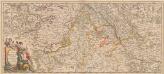
Totius Fluminis Rheni Novissima Descriptio [Karte, Teil 1], in: Novus atlas absolutissimus, Bd. 2, S. 150.
1 Karte aus Atlas Janssonius Offizin
Jiho-západní Německo a Šwejcary
1 : 3300000 Německo jihozápadní Merklas, Václav
Composite: Sud-West Deutschland, Schweiz.
1 : 925000 Vogel, C.
Armoiries des XIII cantons et des alliés
1 : 2500000 1 Karte [Chenebié], [Vevey]
[Schweiz]
1 : 2100000 1 Karte [von Johann Gerhard Reinhard Andreae] [bei Joh. Caspar Füessli Sohn, und in Commission bei Heinrich Steiner und Comp. Buchhändlern], [Winterthur]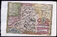
Provincia Helvetiae
Johannes a Montecalerio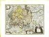
Sveviæ nova tabvla
1 Karte : Kupferdruck ; 35 x 47 cm Blaeu apud Guiljelmum Blaeuw
Circulus Suevicus
1 Karte : Kupferdruck ; 48 x 56 cm Lotter Tobias Konrad Lotter
Sveviae utriusque cum Germanicæ tum Rheticæ celebratissimis vrbibus
1 Karte : Kupferdruck ; 20 x 22 cm, Bildgrösse 21 x 29 cm Seltzlin; Quad; Bussemacher excudit Johan Buchsemecher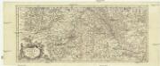
Totius fluminis Rheni novissima descriptio
Rýn, řeka-oblast Wit, Frederick de Frederick de Witt
Geognostische Karte von Württemberg, Baden und Hohenzollern
1 : 700000 Bach, Carl Philipp Heinrich Verlag der G. Ebner'schen Kunsthandlung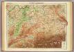
Germany - southern section.
1 : 1000000 John Bartholomew and Son
<<Die>> erst Tafel innhaltend das Schweytzerlandt mit anstossenden Ländern
1 : 750000 1 Karte [Sebastian Münster] [Henricpetri], [Basel]
<<Les>> 13 cantons suisses et leurs allietz
1 : 3500000 1 Karte [Alain Manesson Mallet] [in verlegung Johann David Zunners], [Franckfurt am Mayn]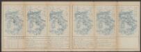
Helvetiae Prima Et VIII. Nova Tabula.[Karte], in: Claud. Ptolemaeus. Geographia lat. cum mappis [...], S. 359.
1 Karte aus Atlas Münster, Sebastian [und Ptolemaeus, Claudius]
Carte von Lottringen Elsass Franche Comte Schweizerland und Würtenberg
1 Karte : Kupferdruck ; 47 x 62 cm Riegel Christoph Riegel
Helvetia prima Rheni et VIII. nova tabula
1 : 750000 1 Karte [Sebastian Münster] [apud Henricum Petrum], [Basilea]
Helvetiae moderna descriptio
1 : 750000 1 Karte [Sebastian Münster] [Henricpetri], [Basel]
Partie des Grisons du haut Rheinthal et ses frontieres au Gouvernement d' Arlberg et Tyrol.
From Atlas Suisse. Levé et dessiné par J. H. Weiss aux fraix de J. R. Meyer á Aarau dans les années 1786 á 1802. Gravée par Guerin, Eichler, et Scheurmann.
Nouvelle description du pais de Souysse
1 : 750000 1 Karte [Sebastian Münster] [Henricpetri], [Basel]
Accuratissima Rheni superioris Mosae et Mosellae tabula ac minores in eosdem influentes fluvii
1 : 950000 1 Karte : Kupferdruck ; 49 x 57 cm Danckerts, Theodorus [Danckerts]
Circulus Suevicus in quo Ducatus Wirtenbergensis cum reliquis Statibus Et Provinciis curate designatus proponitur
Seutter, Matthäus Seutter
<<Die>> erst Tafel innhaltend das Schweytzerlandt mit den anstossenden Ländern
1 : 750000 1 Karte [Sebastian Münster] ; [Theodor de Bry?] [Henric Petri], [Basel]
Circulus Sueviæ
1 Karte : Kupferdruck ; 47 x 54 cm Homann Johann Baptist Homann
Circulus Svevicus
1 Karte : Kupferdruck ; 46 x 65 cm Kraus; Wagner; Wille sumtibus Matthæi Wagner
Circulus Suevicus
1 Karte : Kupferdruck ; 48 x 56 cm Seutter Matthäus Seutter
Totivs Sveviæ novissima tabvla
1 Karte : Kupferdruck ; 37 x 47 cm Janssonius ex officina Ioannis Ianssonii
Svevia
1 Karte : Kupferdruck ; 26 x 34 cm Merian Merian
Helvetiae moderna descriptio
1 : 750000 1 Karte [Sebastian Münster] [Münster], [Basel]
![Totius Fluminis Rheni Novissima Descriptio [Karte, Teil 1], in: Novus atlas absolutissimus, Bd. 2, S. 150.](https://images-2.georeferencer.com/images/iiif/113936403541/full/,300/0/native.jpg)

