Maps of Switzerland

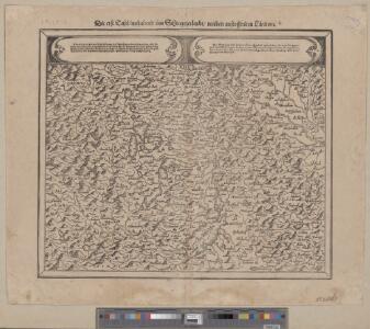
<<Die>> erst Tafel innhaltend das Schweytzerlandt mit anstossenden Ländern
1 : 750000 1 Karte [Sebastian Münster] [Henricpetri], [Basel]
<<Les>> 13 cantons suisses et leurs allietz
1 : 3500000 1 Karte [Alain Manesson Mallet] [in verlegung Johann David Zunners], [Franckfurt am Mayn]
Helvetiae Prima Et VIII. Nova Tabula.[Karte], in: Claud. Ptolemaeus. Geographia lat. cum mappis [...], S. 359.
1 Karte aus Atlas Münster, Sebastian [und Ptolemaeus, Claudius]
<<Die>> erst Tafel innhaltend das Schweytzerlandt mit den anstossenden Ländern
1 : 750000 1 Karte [Sebastian Münster] ; [Theodor de Bry?] [Henric Petri], [Basel]
Helvetiae descriptio
1 Karte : Kupferdruck ; 34 x 44 cm Tschudi; Ortelius s.n.
Helvetiae descriptio
1 Karte : Kupferdruck ; 35 x 45 cm Tschudi; Ortelius s.n.
Helvetia ab antiquo pars Imperii Romano-Germanici
1 : 2100000 1 Karte [Johann Michael Franz] [Johann G. Breitkopf], [Leipzig]
Helvetiae moderna descriptio
1 : 750000 1 Karte [Sebastian Münster] [Henricpetri], [Basel]
Helvetia
1 : 2700000 1 Karte [Petrus Bertius] [sumptibus et typis aeneis Iudoci Hondij], [Amsterodami]
Helvetia
1 : 4200000 1 Karte Aegidio Tschudo auctore [Compagnia Bresciana], [Brescia]
Entwerffung der ietzt-lebenden hochloblich- und hoechst beglueckten Eydgenossschafft
1 : 850000 1 Karte [Johannes Stumpf] [Verlag nicht ermittelbar], [Zürich?]
Armoiries des XIII cantons et des alliés
1 : 2500000 1 Karte [Chenebié], [Vevey]
Helvetia prima Rheni et VIII. nova tabula
1 : 750000 1 Karte [Sebastian Münster] [apud Henricum Petrum], [Basilea]
Topographische Karte der Schweiz (Dufour-Karte): Den Kanton Zürich betreffende Blätter: Blatt XXI: Bonneville, Sallenches; Übersicht der Blätter
1 : 100000 Leitung: Dufour, Guillaume-Henri (1787-1875), General, Politiker, Ingenieur und Kartograf, von Genf; Eidgenössisches Topographisches Bureau, in Genf Stich: Bachofen, Johann Heinrich, andere Schreibweise: Jean-Henri, (1821-1889), Zeichner, Maler, Architekt und Topograf, von Uster; Bressanini, Rinaldo (1803-1864), Kupferstecher und Kartograf, von Italien
Helvetiae moderna descriptio
1 : 750000 1 Karte [Sebastian Münster] [Münster], [Basel]
Nouvelle description du pais de Souysse
1 : 750000 1 Karte [Sebastian Münster] [Henricpetri], [Basel]
Helvetia, Eydtgnossschafft, oder Schweytzerlandt, mit dero Gräntzen
1 Karte formis Davidis Hautii, Lucerne Helvet.
<<[Die>> gantz Eydgnoschafft]
1 : 850000 1 Karte [Johannes Stumpf] [Verlag nicht ermittelbar], [Erscheinungsort nicht ermittelbar]
[Schweiz]
1 : 2100000 1 Karte [von Johann Gerhard Reinhard Andreae] [bei Joh. Caspar Füessli Sohn, und in Commission bei Heinrich Steiner und Comp. Buchhändlern], [Winterthur]
Helvetia
1 : 4200000 1 Karte Aegidio Tschudo auctore [de l'Imprimérie de Christofle Plantin], [Anvers]
Entwerffung der ietzt-lebenden hochloblich- und hoechst beglueckten Eydgenossschafft
1 : 850000 1 Karte [Johannes Stumpf] [Verlag nicht ermittelbar], [Zürich?]
Helvetia
1 : 1900000 1 Karte [Zacharias Heyns] [pour Zacharie Heyns, à l'Enseigne des trois vertus], [Amsterdam]
<<Die>> erst Tafel des Rheinstroms in der vergriffen wirt die Eidtgnoschafft, das Elsass und Brisgoew
1 : 750000 1 Karte [Sebastian Münster] [Henricpetri], [Basel]

<<A>> new map of Swisserland
1 : 750000 1 Karte by John Cary printed for J. Cary, No. 181, Strand, London
Gebiet der Schweitzerischen Eidgenossenschaft
1 : 810000 1 Karte von R. v. L. [i.e. Johann Jakob Otto August Rühle von Lilienstern] [Verlag nicht ermittelbar], Berlin
Reisekarte der Schweiz
1 : 1000000 1 Karte entworfen und gezeichnet v. E. Winckelmann ; Lith. Anst. von Pobuda, Rees et Cie. Hoffmansche Verlagshandlung, Stuttgart
Helvetiae prima et VIII nova tabula
1 : 750000 1 Karte [Sebastian Münster] [per Henrichum Petrum], [Basileae]
Republick Schweiz
1 : 4000000 1 Karte [Verlag des Buchladens der Real-Schule], [Berlin]