Maps of Switzerland

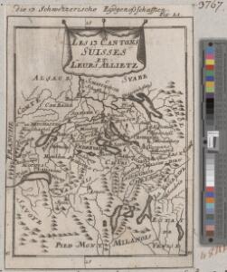
<<Les>> 13 cantons suisses et leurs allietz
1 : 3500000 1 Karte [Alain Manesson Mallet] [in verlegung Johann David Zunners], [Franckfurt am Mayn]
Armoiries des XIII cantons et des alliés
1 : 2500000 1 Karte [Chenebié], [Vevey]
Entwerffung der ietzt-lebenden hochloblich- und hoechst beglueckten Eydgenossschafft
1 : 850000 1 Karte [Johannes Stumpf] [Verlag nicht ermittelbar], [Zürich?]
<<Die>> erst Tafel innhaltend das Schweytzerlandt mit anstossenden Ländern
1 : 750000 1 Karte [Sebastian Münster] [Henricpetri], [Basel]
Helvetia, Eydtgnossschafft, oder Schweytzerlandt, mit dero Gräntzen
1 Karte formis Davidis Hautii, Lucerne Helvet.
Helvetia
1 : 4200000 1 Karte Aegidio Tschudo auctore [Compagnia Bresciana], [Brescia]
<<A>> new map of Swisserland
1 : 750000 1 Karte by John Cary printed for J. Cary, No. 181, Strand, London
Entwerffung der ietzt-lebenden hochloblich- und hoechst beglueckten Eydgenossschafft
1 : 850000 1 Karte [Johannes Stumpf] [Verlag nicht ermittelbar], [Zürich?]
Helvetia
1 : 4200000 1 Karte Aegidio Tschudo auctore [de l'Imprimérie de Christofle Plantin], [Anvers]
<<[Die>> gantz Eydgnoschafft]
1 : 850000 1 Karte [Johannes Stumpf] [Verlag nicht ermittelbar], [Erscheinungsort nicht ermittelbar]
Suisse
1 : 3500000 1 Karte [Alain Manesson Mallet] [in verlegung Johann David Zunners], [Franckfurt am Mayn]
Helvetiae descriptio
1 Karte : Kupferdruck ; 34 x 44 cm Tschudi; Ortelius s.n.
Helvetiae descriptio
1 Karte : Kupferdruck ; 35 x 45 cm Tschudi; Ortelius s.n.
<<Les>> Suisses, les alliés des Suisses et leurs sujets
1 Karte par N. Sanson d'Abbeville ; R. Cordier sculp. [Verlag nicht ermittelbar], [Erscheinungsort nicht ermittelbar]
<<Les>> 13 cantons suisses et leurs alliéz
1 : 3500000 1 Karte [Alain Manesson Mallet] [chez Denys Thierry?], [Paris]
Helvetiae conterminarumque terrarum antiqua descriptio
1 : 2000000 1 Karte [Stich von Girolamo Porro] ; [hrsg. von Giovanni Antonio Magini] [Verlag nicht ermittelbar], [Erscheinungsort nicht ermittelbar]
Helvetiae Prima Et VIII. Nova Tabula.[Karte], in: Claud. Ptolemaeus. Geographia lat. cum mappis [...], S. 359.
1 Karte aus Atlas Münster, Sebastian [und Ptolemaeus, Claudius]
Helvetia
1 : 1900000 1 Karte [Zacharias Heyns] [pour Zacharie Heyns, à l'Enseigne des trois vertus], [Amsterdam]
Assemblage de l' atlas Suisse.
From Atlas Suisse. Levé et dessiné par J. H. Weiss aux fraix de J. R. Meyer á Aarau dans les années 1786 á 1802. Gravée par Guerin, Eichler, et Scheurmann.
Reisekarte der Schweiz
1 : 1000000 1 Karte entworfen und gezeichnet v. E. Winckelmann ; Lith. Anst. von Pobuda, Rees et Cie. Hoffmansche Verlagshandlung, Stuttgart
<<Die>> dreyzehend Tafel haltet inn ein Verzeichnung der loblichen Eydgnoschafft und irer Zuogewandten sampt dem Alpgebirg und nächsten Anstössen
1 : 900000 1 Karte [Johannes Stumpf] [Froschauer], [Zürich]
<<Die>> Schweiz
1 : 1470000 1 Karte Perthes, Gotha
Suisse
1 : 2500000 1 Karte by Rt. Morden [printed for Robert Morden and Thomas Cockerill?], [London]
<<La>> Suisse
1 : 2000000 1 Karte [Verlag nicht ermittelbar], [Paris?]
Helvetia
1 : 1900000 1 Karte [Verlag nicht ermittelbar], [Erscheinungsort nicht ermittelbar]
Umriss von der Schweiz nach der neuen Eintheilung von 1798
1 : 750000 1 Karte [Verlag nicht ermittelbar], [Erscheinungsort nicht ermittelbar]
Topographische Karte der Schweiz (Dufour-Karte): Den Kanton Zürich betreffende Blätter: Blatt XXI: Bonneville, Sallenches; Übersicht der Blätter
1 : 100000 Leitung: Dufour, Guillaume-Henri (1787-1875), General, Politiker, Ingenieur und Kartograf, von Genf; Eidgenössisches Topographisches Bureau, in Genf Stich: Bachofen, Johann Heinrich, andere Schreibweise: Jean-Henri, (1821-1889), Zeichner, Maler, Architekt und Topograf, von Uster; Bressanini, Rinaldo (1803-1864), Kupferstecher und Kartograf, von Italien
Le Cours du Danube
1 : 1800000 Mollova mapová sbírka Placide de Sainte-Hélène Inselin, Charles
Nova Rhaetiae atque totius Helvetiae descriptio
1 : 350000 1 Karte auf 10 Bl. per Aegidium Tschudum Glaronensem Hofer & Burger, Zürich