Maps of Switzerland

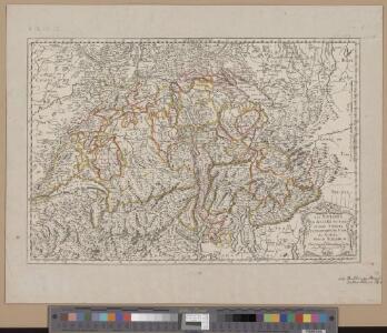
<<Les>> Suisses, les alliés des Suisses et leurs sujets
1 Karte par N. Sanson d'Abbeville ; R. Cordier sculp. [Verlag nicht ermittelbar], [Erscheinungsort nicht ermittelbar]
Carte générale physique et routière des 22 cantons de la confédération Suisse
1 : 750000 1 Karte par A.H. Brué ; gravée sous la direction de l'auteur ; les montagnes gravées par Dandeleux Brué, Paris
<<La>> Suisse
1 : 1300000 1 Karte Pierre vander Aa chez Pierre vander Aa, Leide
<<Die>> Schweiz
1 : 1754419 1 Karte bei I. P. Spehr, Braunschweig
Carte générale de la Suisse
1 : 850000 1 Karte par Clermont 1781 ; Perrier sculp. [de l'Imprimerie de Clousier, rue Saint-Jacques], [Paris]
Suisse, or, Switzerland with their allies and subjects &c
1 : 1350000 1 Karte by H. Moll [printed for Thomas and John Bowles?], [London]
Switzerland and the country of the Grisons wherein is described the XIII Switz Cantons with their allies &c
1 Karte revised by I. Senex [Verlag nicht ermittelbar], [Erscheinungsort nicht ermittelbar]
<<Die>> Schweiz
1 : 1470000 1 Karte Perthes, Gotha
Ansiedlung der Alamannen [und] Burgunder
1 : 1700000 1 Karte Kartogr. Anstalt Hofer & Co., Zürich
Carte der Schweiz zu dem kleinen Atlass mit Beschreibung der Merkwürdigkeiten der Schweiz
1 : 900000 1 Karte [Verlag nicht ermittelbar], [Erscheinungsort nicht ermittelbar]
Helvetiae conterminarumque terrarum antiqua descriptio
1 : 2000000 1 Karte [Stich von Girolamo Porro] ; [hrsg. von Giovanni Antonio Magini] [Verlag nicht ermittelbar], [Erscheinungsort nicht ermittelbar]
<<Die>> 8 alten Orte beim Abschluss des 50jährigen Friedens mit Oesterreich anno 1412
1 : 1700000 1 Karte Kartogr. Anstalt Hofer & Co., Zürich
Reisekarte der Schweiz
1 : 1000000 1 Karte entworfen und gezeichnet v. E. Winckelmann ; Lith. Anst. von Pobuda, Rees et Cie. Hoffmansche Verlagshandlung, Stuttgart
Suisse
1 : 2500000 1 Karte by Rt. Morden [printed for Robert Morden and Thomas Cockerill?], [London]
<<Die>> Schweiz
1 : 1025000 1 Karte entw. u. gez. von [Friedrich H.] Handke [i.e. Handtke] ; H. Müller lith. Flemming, Glogau
Suisse
1 : 3600000 1 Karte V. Levasseur ; gravé par: Laguillermie [Bureaux du Journal des connaissances utiles], [Paris]
Geologische Spezialkarte des Grossherzogtums Baden, Blatt 144: Stühlingen: Karte XIII: Die eine und unteilbare Helvetische Republik 1798-1802
Bearbeitung: Vögelin, J. K.; Meyer von Knonau, G.
Geologische Spezialkarte des Grossherzogtums Baden, Blatt 144: Stühlingen: Karte XIV: Die neunzehn Kantone der Mediationsperiode
Mit Angabe der Veränderung nach dem Sturze Napoleons. Bearbeitung: Vögelin, J. K.; Meyer von Knonau, G.
Suisse
1 : 1500000 1 Karte [Verlag nicht ermittelbar], [Erscheinungsort nicht ermittelbar]
<<A>> new map of Swisserland
1 : 750000 1 Karte by John Cary printed for J. Cary, No. 181, Strand, London
<<Die>> 19 Cantone der Vermittlungsakte von 1803-15
1 : 1700000 1 Karte Kartogr. Anstalt Hofer & Co., Zürich
Helvetia, Rhaetia, Valesia
1 : 580000 1 Karte labore et studio Henrici Ludovici Muoss bei dem Author, Zug
Entwerffung der ietzt-lebenden hochloblich- und hoechst beglueckten Eydgenossschafft
1 : 850000 1 Karte [Johannes Stumpf] [Verlag nicht ermittelbar], [Zürich?]
<<Die>> Republic Schweitz mit ihren Unterthanen und Bundsgenossen
1 : 1900000 1 Karte verfertiget von Joh. George Schreibern [Schreiber], Leipzig
1e. carte de Suisse
1 : 700000 1 Karte [par Jean Palairet] [chez Mess. J. Nourse & P. Vaillant dans le Strand], [Londres]
Helvetia, Eydtgnossschafft, oder Schweytzerlandt, mit dero Gräntzen
1 Karte formis Davidis Hautii, Lucerne Helvet.
Geologische Spezialkarte des Grossherzogtums Baden, Blatt 144: Stühlingen: Karte VIII: Die Eidgenossenschaft der Dreizehn Alten Orte zur Zeit der Anerkennung ihrer Unabhängigkeit durch den Westfälischen Frieden
Bearbeitung: Vögelin, J. K.; Meyer von Knonau, G. Lithografie: Schulthess, Friedrich (1804-1869), Leiter Buchhandlung und Druckerei, von Zürich
Erste Post- & Dampfschifffahrt Reise Carte der Schweiz
1 : 750000 1 Karte entworfen, bearb. und einer hochloblichen Post-Commission der Stadt Basel ergebenst gewidmet von Hiers. Rumpf ; auf Stein gestochen von C. Bruder E. Hindermann's Witwe, Basel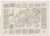
Historisch-geographischer Atlas der Schweiz: Karte XIII: Die eine und unteilbare Helvetische Republik 1798-1802
Mit Beiblatt. Bearbeitung: Vögelin, J. K.; Meyer von Knonau, G.