Maps of Switzerland

Carte von Lottringen Elsass Franche Comte Schweizerland und Würtenberg
1 Karte : Kupferdruck ; 47 x 62 cm Riegel Christoph Riegel
Accuratissima Rheni superioris Mosae et Mosellae tabula ac minores in eosdem influentes fluvii
1 : 950000 1 Karte : Kupferdruck ; 49 x 57 cm Danckerts, Theodorus [Danckerts]
Le Cours de la Riviere du Rhein
1 : 1100000 Mollova mapová sbírka Sanson, Guillaume Mortier, Pierre
Le Cours de la Riviere du Rhein
1 : 1100000 Mollova mapová sbírka Sanson, Guillaume Schenk, Peter I
Carte von Lottringen Elsass, Franche Comté Schweizerland und Würtenberg
1 Karte : Kupferdruck ; 47 x 62 cm Riegel beÿ Christoph Riegel
[Duché de Lorraine, Franche Comté, Duché de Wurtemberg, Le Suisse]
1 : 740000 [S.l.] : [s.n.]
Tabula Geographica qua Pars Meridionalis sive Superior Rheni, Mosae et Mosellae
1 : 1100000 Mollova mapová sbírka Visscher, Nicolaes Jansz. Visscher, Nicolaus
Tabula Geographica qua Pars Meridionalis sive Superior Rheni, Mosae et Mosellae
1 : 1100000 Mollova mapová sbírka Visscher, Nicolaes Jansz. Visscher, Nicolaus
Armoiries des XIII cantons et des alliés
1 : 2500000 1 Karte [Chenebié], [Vevey]
Helvetiae descriptio
1 Karte : Kupferdruck ; 34 x 44 cm Tschudi; Ortelius s.n.
Helvetiae descriptio
1 Karte : Kupferdruck ; 35 x 45 cm Tschudi; Ortelius s.n.
[Schweiz]
1 : 2100000 1 Karte [von Johann Gerhard Reinhard Andreae] [bei Joh. Caspar Füessli Sohn, und in Commission bei Heinrich Steiner und Comp. Buchhändlern], [Winterthur]
Composite: Sud-West Deutschland, Schweiz.
1 : 925000 Vogel, C.
Kurtz verzeichnete Vorstellung dess alten Helvetier-Lands mit ihren Anstoessen nach Julii Caesaris Beschreibung
1 Karte [Johannes Stumpf] [Verlag nicht ermittelbar], [Erscheinungsort nicht ermittelbar]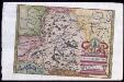
Provincia Helvetiae
Johannes a Montecalerio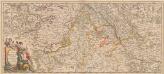
Totius Fluminis Rheni Novissima Descriptio [Karte, Teil 1], in: Novus atlas absolutissimus, Bd. 2, S. 150.
1 Karte aus Atlas Janssonius Offizin
Partie des Grisons du haut Rheinthal et ses frontieres au Gouvernement d' Arlberg et Tyrol.
From Atlas Suisse. Levé et dessiné par J. H. Weiss aux fraix de J. R. Meyer á Aarau dans les années 1786 á 1802. Gravée par Guerin, Eichler, et Scheurmann.
<<Die>> vierdt Landtafel haltet inn die alt Helvetiam Iulii Cesaris mit iren Anstössen wie die im vierdten Buoch verzeichnet wirt
1 : 700000 1 Karte [Johannes Stumpf] [Froschauer], [Zürich]
Entwerffung der ietzt-lebenden hochloblich- und hoechst beglueckten Eydgenossschafft
1 : 850000 1 Karte [Johannes Stumpf] [Verlag nicht ermittelbar], [Zürich?]
Kurtz verzeichnete Vorstellung dess alten Helvetier-Lands mit ihren Anstoessen nach Iulii Caesaris Beschreibung
1 : 700000 1 Karte [Johannes Stumpf] [Verlag nicht ermittelbar], [Zürich?]
<<Die>> erst Tafel innhaltend das Schweytzerlandt mit anstossenden Ländern
1 : 750000 1 Karte [Sebastian Münster] [Henricpetri], [Basel]
Carte Militaire de la Suisse.
Jouvet et Cie.
<<[Die>> gantz Eydgnoschafft]
1 : 850000 1 Karte [Johannes Stumpf] [Verlag nicht ermittelbar], [Erscheinungsort nicht ermittelbar]
Landgraviatus Alsatiae
1 : 340000 Alsasko (Francie) Homann, Johann Baptist Ioh. Baptista Homanno
Landgraviatus Alsatiae
1 : 340000 Alsasko (Francie) Homann, Johann Baptist J. B. Homann
Landgraviatus Alsatiae
1 : 340000 Alsasko (Francie) Homann, Johann Baptist Ioh. Baptista Homanno
<<A>> new map of Swisserland
1 : 750000 1 Karte by John Cary printed for J. Cary, No. 181, Strand, London
<<Die>> erst Tafel innhaltend das Schweytzerlandt mit den anstossenden Ländern
1 : 750000 1 Karte [Sebastian Münster] ; [Theodor de Bry?] [Henric Petri], [Basel]
<<Les>> 13 cantons suisses et leurs allietz
1 : 3500000 1 Karte [Alain Manesson Mallet] [in verlegung Johann David Zunners], [Franckfurt am Mayn]


