Maps of Bayern
Sveviæ nova tabvla
1 Karte : Kupferdruck ; 35 x 47 cm Blaeu apud Guiljelmum Blaeuw
Jiho-západní Německo a Šwejcary
1 : 3300000 Německo jihozápadní Merklas, Václav
La Souabe
1 Karte : Kupferdruck ; 39 x 40 cm Sanson chez l'autheur
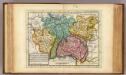
Südwestliches Deutschland, enth. Bayern, Würtemberg, Baden, Hohenzollern und Schweiz
Hand-Atlas über alle Theile der Erde nach dem neuesten Zustande und über das Weltgebäude Stieler, Adolf bei Justus Perthes
Germany (Deutschland)
1 : 1750000 Bavorsko (Německo) Baldwin & Cradock
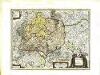
[Südwestliches Deutschland und Schweiz]
Stieler's Hand-Atlas Stieler, Adolf bei Justus Perthes
Südwestliches Deutschland, enth. Bayern, Würtemberg, Baden, Hohenzollern und Schweiz
Hand-Atlas über alle Theile der Erde nach dem neuesten Zustande und über das Weltgebäude Stieler, Adolf bei Justus Perthes
Souabe, Baviere.
1 : 2900000 Clouet, J. B. L. (Jean-Baptiste Louis), b. 1730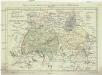
Postkarte von dem Bayrischen und Schwaebischen Kreise
Bavorsko (Německo) Müller, Franz Deilly'schen Lankarten und Kunstwerke Verschleiss Komtoir
Postkarte von dem Bayrischen und Schwaebischen Kreise
Bavorsko (Německo) Müller, Franz im von Reilly'schen Landkarten und Kunstwerke Verschleiss Komptoir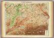
Germany - southern section.
1 : 1000000 John Bartholomew and Son
Raetiae veteris exterae et hodiernae una cum regionibus ei guondam [i.e. quondam] adnumeratis & finitimarum regionum limitibus tabula generalis
1 : 1100000 1 Karte Matth. Hirtzg. ; Leo. Scherer [Joh. Rodolff Wolffen], [Zürich]
Sudwestliches Deutschland
1 : 1850000 Stieler, Adolf

Composite I, II, VI, VII: Karte Des Oesterreichischen Kaiserstaates.
1 : 576000 Scheda, Josef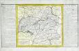
Cercle de Souabe
1 Karte : Kupferdruck ; 29 x 32 cm, Bildgrösse 31 x 55 cm Clouet Mondhare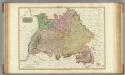
Germany south of the Mayn.
1 : 885000 Pinkerton, John, 1758-1826
Höhen Charte oder bildlich vergleichende Uebersicht der bedeutendesten Berge in Deutschland und der Schweiz
1 : 22000 Německo Weiland, Karl Ferdinand Geograph. Institut
Suevia Et Bavaria XI. Nova Tabula. [Karte], in: Geographia universalis vetus et nova complectens Claudii Ptolemaei Alexandrini enarrationis libros VIII, S. 329.
1 Karte aus Atlas Münster, Sebastian [und Ptolemaeus, Claudius]
Karte von Deutschland in IV Blättern
1 : 825000 Südwest-Blatt Sotzmann, Daniel Friedrich im Verlage der A. G. Schneider und Weigels
Haupt-Dreiecknetz für das Königreich Bayern
1 : 1000000 Stiglmayer Contur Obernetter Schrift [gravirt] [S.l.] : [s.n.]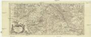
Totius fluminis Rheni novissima descriptio
Rýn, řeka-oblast Wit, Frederick de Frederick de Witt
Suevia Et Bavaria XII. Nova Tabula. [Karte], in: Claud. Ptolemaeus. Geographia lat. cum mappis [...], S. 383.
1 Karte aus Atlas Münster, Sebastian [und Ptolemaeus, Claudius]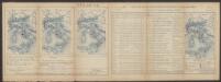
Suevia Et Bavaria XI. Nova Tabula. [Karte], in: Claud. Ptolemaeus. Geographia lat. cum mappis [...], S. 380.
1 Karte aus Atlas Münster, Sebastian [und Ptolemaeus, Claudius]
Totivs Sveviæ novissima tabvla
1 Karte : Kupferdruck ; 37 x 47 cm Janssonius ex officina Ioannis Ianssonii
Svevia
1 Karte : Kupferdruck ; 26 x 34 cm Merian Merian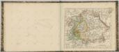

[Atlas zur Geschichte von Bayern] : I. Rhaetia, Noricum und die angränzenden Länder
K. v. Spruner [Gotha : Perthes]
Südwestliches Deutschland
Neuer Handatlas über alle Theile der Erde Kiepert, Heinrich Verlag von Dietrich Reimer