Maps of Switzerland
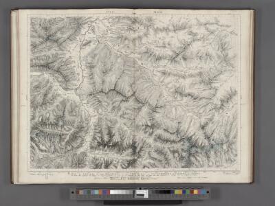
Partie des Grisons du haut Rheinthal et ses frontieres au Gouvernement d' Arlberg et Tyrol.
From Atlas Suisse. Levé et dessiné par J. H. Weiss aux fraix de J. R. Meyer á Aarau dans les années 1786 á 1802. Gravée par Guerin, Eichler, et Scheurmann.
Provincia Helvetiae
Johannes a Montecalerio
[Schweiz]
1 : 2100000 1 Karte [von Johann Gerhard Reinhard Andreae] [bei Joh. Caspar Füessli Sohn, und in Commission bei Heinrich Steiner und Comp. Buchhändlern], [Winterthur]
<<Die>> erst Tafel innhaltend das Schweytzerlandt mit anstossenden Ländern
1 : 750000 1 Karte [Sebastian Münster] [Henricpetri], [Basel]
Natur und Kunst Producten Karte von Vorder Oestreich
1 Karte : Kupferdruck ; 25 x 33 cm Blum von Kempen; Bernard Johann Otto
<<Les>> 13 cantons suisses et leurs allietz
1 : 3500000 1 Karte [Alain Manesson Mallet] [in verlegung Johann David Zunners], [Franckfurt am Mayn]
Totius Fluminis Rheni Novissima Descriptio [Karte, Teil 1], in: Novus atlas absolutissimus, Bd. 2, S. 150.
1 Karte aus Atlas Janssonius Offizin
Helvetiae descriptio
1 Karte : Kupferdruck ; 34 x 44 cm Tschudi; Ortelius s.n.
Helvetiae descriptio
1 Karte : Kupferdruck ; 35 x 45 cm Tschudi; Ortelius s.n.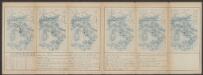
Helvetiae Prima Et VIII. Nova Tabula.[Karte], in: Claud. Ptolemaeus. Geographia lat. cum mappis [...], S. 359.
1 Karte aus Atlas Münster, Sebastian [und Ptolemaeus, Claudius]
Carte von Lottringen Elsass Franche Comte Schweizerland und Würtenberg
1 Karte : Kupferdruck ; 47 x 62 cm Riegel Christoph Riegel
<<Die>> erst Tafel innhaltend das Schweytzerlandt mit den anstossenden Ländern
1 : 750000 1 Karte [Sebastian Münster] ; [Theodor de Bry?] [Henric Petri], [Basel]
Helvetia
1 : 2700000 1 Karte [Petrus Bertius] [sumptibus et typis aeneis Iudoci Hondij], [Amsterodami]
Helvetia prima Rheni et VIII. nova tabula
1 : 750000 1 Karte [Sebastian Münster] [apud Henricum Petrum], [Basilea]
Helvetiae moderna descriptio
1 : 750000 1 Karte [Sebastian Münster] [Henricpetri], [Basel]
Carte Militaire de la Suisse.
Jouvet et Cie.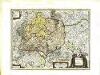
Sveviæ nova tabvla
1 Karte : Kupferdruck ; 35 x 47 cm Blaeu apud Guiljelmum Blaeuw
<<Die>> erst Tafel innhaltend das Schweytzerlandt mit anstossenden Ländern
1 : 750000 1 Karte [Sebastian Münster] [Henricpetri], [Basel]
Nouvelle description du pais de Souysse
1 : 750000 1 Karte [Sebastian Münster] [Henricpetri], [Basel]
Carte du comté de Tirol et des possessions de la maison d'Autriche dans le cercle de Souabe
1 : 1380000 Rakousko (1526-1804) Mentelle, Edme Tardieu, Pierre François
<<Les>> Suisses, les alliés des Suisses et leurs sujets
1 Karte par N. Sanson d'Abbeville ; R. Cordier sculp. [Verlag nicht ermittelbar], [Erscheinungsort nicht ermittelbar]
Helvetiae moderna descriptio
1 : 750000 1 Karte [Sebastian Münster] [Münster], [Basel]
Helvetia ab antiquo pars Imperii Romano-Germanici
1 : 2100000 1 Karte [Johann Michael Franz] [Johann G. Breitkopf], [Leipzig]
<<[Die>> gantz Eydgnoschafft]
1 : 850000 1 Karte [Johannes Stumpf] [Verlag nicht ermittelbar], [Erscheinungsort nicht ermittelbar]
<<Die>> erst Tafel des Rheinstroms in der vergriffen wirt die Eidtgnoschafft, das Elsass und Brisgoew
1 : 750000 1 Karte [Sebastian Münster] [Henricpetri], [Basel]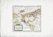
Die in und um Schwaben gelegenen östreichischen Antheile in der ämtlichen Sprache Vorderöstreich
1 Karte : Kupferdruck ; 22 x 24 cm Reilly F. J. J. von Reilly
VI, uit: General-Karte des oesterreichischen Kaiserstaates mit einem grossen Theile der angrenzenden Länder / durch Josef Scheda ... bearb. und hrsg
1 : 576000 Annotatie geografische gegevens: Maatstokken: oesterreichische Meilen, geografische oder deutsche Meilen, preussische Meilen, türkische Berri, französische Lieues, russische Werste; Maatstok per blad: wiener Klafter, öster. Meilen; Blad XIX: statistische en taalkundige informatie; Blad XIX: legenda [Wien : K.K. Militärisch-Geografisches Institut]
Nova et Accuratißima Galliae Tabula, Vulgo Royaume De France
1 : 920000 Mollova mapová sbírka Danckerts, Justus Danckerts, Justus
Totivs Sveviæ novissima tabvla
1 Karte : Kupferdruck ; 37 x 47 cm Janssonius ex officina Ioannis Ianssonii