Maps of Switzerland

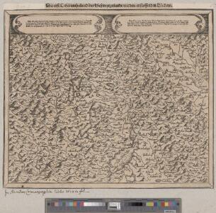
<<Die>> erst Tafel innhaltend das Schweytzerlandt mit anstossenden Ländern
1 : 750000 1 Karte [Sebastian Münster] [Henricpetri], [Basel]
Carte Militaire de la Suisse.
Jouvet et Cie.
Helvetia
1 : 2700000 1 Karte [Petrus Bertius] [sumptibus et typis aeneis Iudoci Hondij], [Amsterodami]
Helvetiae Prima Et VIII. Nova Tabula.[Karte], in: Claud. Ptolemaeus. Geographia lat. cum mappis [...], S. 359.
1 Karte aus Atlas Münster, Sebastian [und Ptolemaeus, Claudius]
Helvetia
1 : 2700000 1 Karte [Petrus Bertius] [durch Matth. Beckern, in Verlegung Heinrich Lorentzen], [Franckfurt]
<<Die>> erst Tafel innhaltend das Schweytzerlandt mit anstossenden Ländern
1 : 750000 1 Karte [Sebastian Münster] [Henricpetri], [Basel]
Helvetia ab antiquo pars Imperii Romano-Germanici
1 : 2100000 1 Karte [Johann Michael Franz] [Johann G. Breitkopf], [Leipzig]

Helvetiae moderna descriptio
1 : 750000 1 Karte [Sebastian Münster] [Henricpetri], [Basel]
Nouvelle description du pais de Souysse
1 : 750000 1 Karte [Sebastian Münster] [Henricpetri], [Basel]
Helvetiae moderna descriptio
1 : 750000 1 Karte [Sebastian Münster] [Münster], [Basel]
Helvetia prima Rheni et VIII. nova tabula
1 : 750000 1 Karte [Sebastian Münster] [apud Henricum Petrum], [Basilea]
Charte des Gesichtskreises vom Rigi-Kulm
1 : 2710000 1 Karte H.K. [i.e. Heinrich Keller] [Heinrich Keller], [Zürich]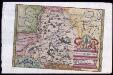
Provincia Helvetiae
Johannes a Montecalerio
<<Die>> erst Tafel innhaltend das Schweytzerlandt mit den anstossenden Ländern
1 : 750000 1 Karte [Sebastian Münster] ; [Theodor de Bry?] [Henric Petri], [Basel]
Gebiet der Schweitzerischen Eidgenossenschaft
1 : 810000 1 Karte von R. v. L. [i.e. Johann Jakob Otto August Rühle von Lilienstern] [Verlag nicht ermittelbar], Berlin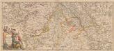
Totius Fluminis Rheni Novissima Descriptio [Karte, Teil 1], in: Novus atlas absolutissimus, Bd. 2, S. 150.
1 Karte aus Atlas Janssonius Offizin
Umriss von der Schweiz nach der neuen Eintheilung von 1798
1 : 750000 1 Karte [Verlag nicht ermittelbar], [Erscheinungsort nicht ermittelbar]
<<Die>> alten Bisthümer von Helvetien und Raetien
1 : 2000000 1 Karte [bearb. nach Urkunden und den vorzüglichsten Werken Schweizerischer Geschichte von E. Scheuermann] [Scheuermann], [Aarau]
Helvetiae prima et VIII nova tabula
1 : 750000 1 Karte [Sebastian Münster] [per Henrichum Petrum], [Basileae]
Partie des Grisons du haut Rheinthal et ses frontieres au Gouvernement d' Arlberg et Tyrol.
From Atlas Suisse. Levé et dessiné par J. H. Weiss aux fraix de J. R. Meyer á Aarau dans les années 1786 á 1802. Gravée par Guerin, Eichler, et Scheurmann.
<<Les>> Suisses, les alliés des Suisses et leurs sujets
1 Karte par N. Sanson d'Abbeville ; R. Cordier sculp. [Sanson], [Paris]
[Süd-West Deutschland und Schweiz, Südlicher Theil]
Handatlas über alle Theile der Erde und über das Weltgebäude Stieler, Adolf Justus Perthes
Helvetia
1 : 1900000 1 Karte [Verlag nicht ermittelbar], [Erscheinungsort nicht ermittelbar]
<<Die>> dreyzehend Tafel haltet inn ein Verzeichnung der loblichen Eydgnoschafft und irer Zuogewandten sampt dem Alpgebirg und nächsten Anstössen
1 : 850000 1 Karte [Johannes Stumpf] [Wieland], [Gattikon]
<<Die>> Eydtgnoschafft, Pünten und Wallis
1 : 1000000 1 Karte Hans Conrd [i.e. Conrad] Geiger fecit [Merian], [Frankfurt]
<<Die>> Schweiz
1 : 930000 1 Karte entw. u. gez. v. A. St. 1820 ; Carl Jättnig sculp. [Perthes], [Gotha]
Erste Manuskriptkarte der Schweiz
1 : 200000 Originaltitel: Der gantzen Loblichen Eydtgnoschafft mit allen angrenzenden Orten gründtliche neüwe verzeychnus vnd uftheylung nach Geographischer ahnleitung gestelt und in diss werkh gebracht. Mit den Wappen der 13 Orte und der 11 Zugewandten Orte (am oberen Kartenrand) sowie einem Gyger-Wappen. Gyger, Hans Conrad, andere Schreibweisen: Geiger, Geyger, (1599-1674), Kartograf und Ingenieur, von Zürich
Helvetia tredecim statibus liberis quos cantones vocant, composita, una cum foederatis & subjectis provinciis
1 : 650000 1 Karte ex probatissimis subsidiis geographice delineata per Tobiam Mayerum luci publicae tradita ab Homannianis Heredibus, Norimbergae