Maps of Switzerland

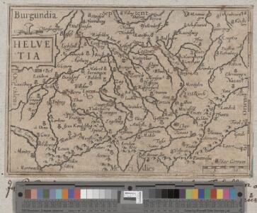
Helvetia
1 : 2700000 1 Karte [Petrus Bertius] [durch Matth. Beckern, in Verlegung Heinrich Lorentzen], [Franckfurt]
Helvetia
1 : 2700000 1 Karte [Petrus Bertius] [sumptibus et typis aeneis Iudoci Hondij], [Amsterodami]
<<Les>> Suisses, les alliés des Suisses et leurs sujets
1 Karte par N. Sanson d'Abbeville ; R. Cordier sculp. [Sanson], [Paris]
Helvetiae conterminarumque terrarum antiqua descriptio
1 : 2000000 1 Karte [Stich von Girolamo Porro] ; [hrsg. von Giovanni Antonio Magini] [Verlag nicht ermittelbar], [Erscheinungsort nicht ermittelbar]
<<Die>> Schweiz
1 : 930000 1 Karte entw. u. gez. v. A. St. 1820 ; Carl Jättnig sculp. [Perthes], [Gotha]
Helvetiae Prima Et VIII. Nova Tabula.[Karte], in: Claud. Ptolemaeus. Geographia lat. cum mappis [...], S. 359.
1 Karte aus Atlas Münster, Sebastian [und Ptolemaeus, Claudius]
Helvetia tredecim statibus liberis quos cantones vocant, composita, una cum foederatis & subjectis provinciis
1 : 650000 1 Karte ex probatissimis subsidiis geographice delineata per Tobiam Mayerum luci publicae tradita ab Homannianis Heredibus, Norimbergae
<<Die>> erst Tafel innhaltend das Schweytzerlandt mit anstossenden Ländern
1 : 750000 1 Karte [Sebastian Münster] [Henricpetri], [Basel]
Atlas novus Reipublicae Helveticae
1 Atlas ([40] Bl., 97 S.) bey Orell, Gessner und Compagnie, Zürich
78. Switzerland. Geneva. The World Atlas.
1 : 1250000 USSR (Union of Soviet Socialist Republics).
Historisch-Geographischer Atlas der Schweiz in 15 Blättern
1 : 770000 Helvetien 1218 - 1331 Voegelin, Johann Conrad ; Meyer von Knonau, Gerold ; Wyss, Georg von ; Meyer von Knonau, Gerold Schulthess
<<Die>> alten Bisthümer von Helvetien und Raetien
1 : 2000000 1 Karte [bearb. nach Urkunden und den vorzüglichsten Werken Schweizerischer Geschichte von E. Scheuermann] [Scheuermann], [Aarau]
Carte physique et politique de la Suisse
1 : 900000 1 Karte par E. Mentelle et P.G. Chanlaire an VI ; gravé par [Alexandre] Blondeau P.G. Chanlaire et E. Mentelle, Paris
Carte générale des trèze cantons de Suisse, Vallay, ligues Grise, Maison-Dieu & Valteline
1 : 725000 1 Karte [par Nicolas Berey] 1654 chez N. Langlois, rue S. Jacques à la Victoire, Paris
<<Die>> VIII alten Orte zu Ende der Burgundischen Kriege
1 : 2000000 1 Karte [bearb. nach Urkunden und den vorzüglichsten Werken Schweizerischer Geschichte von E. Scheuermann] [Scheuermann], [Aarau]
Novissima foederatorum Helvetiorum tabula
1 : 2000000 1 Karte [Weigel], [Nürnberg]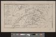
Charte des Gesichtskreises vom Rigi-Kulm
1 : 2710000 1 Karte H.K. [i.e. Heinrich Keller] [Heinrich Keller], [Zürich]
<<La>> repubblica Elvetica eve si veggono colle rispettive loro divisioni i cantoni di cui è stata composta dopo gli ultimi decreti
1 : 500000 1 Karte spatta dal sig. H.M. [i.e. Henri Mallet] ingeg.e geografo ; Gius.e Pezze inc. [Verlag nicht ermittelbar], [Erscheinungsort nicht ermittelbar]
Helvetia prima Rheni et V. nova tabula
1 : 750000 1 Karte [Sebastian Münster] [apud Henricum Petrum], [Basilea]
Helvetiae moderna descriptio
1 : 750000 1 Karte [Sebastian Münster] [Henricpetri], [Basel]
Nova totius Helvetiae cum suis subditis ac sociis tab. geogr
1 : 790000 1 Karte studio manu ac sumtibus Matth. Seut. Seutter, [Augsburg]
Gebiet der Schweitzerischen Eidgenossenschaft
1 : 810000 1 Karte von R. v. L. [i.e. Johann Jakob Otto August Rühle von Lilienstern] [Verlag nicht ermittelbar], Berlin
<<Die>> Helvetische Republik in Cantone und Districte eingetheilt
1 : 630000 1 Karte gedruckt bey Wilhelm Haas dem Sohne, Basel
<<Die>> Schweiz
1 : 930000 1 Karte entw. u. gez. v. Ad. St. 1820 ; Situation gest. v. L. Thiel ; die Schrift von I.B. [Perthes], [Gotha]
[La Suisse]
1 : 2900000 1 Karte [par J.H. Schneider?] [Schneider?], [Amsterdam?]
Carte générale de la Suisse
1 Karte dressée en 1787 d'apres les observations les plus récentes et les plus exactes, pour servir a la nouvelle édition très augmentée du dictionnaire de la Suisse chez BMC [i.e. Barde, Manget & Compagnie], Genève
<<La>> Suisse
1 : 2000000 1 Karte [Verlag nicht ermittelbar], [Paris?]
<<Die>> Schweiz oder helvetische Eidgenossenschaft
1 : 600000 1 Karte entworfen und gezeichnet von C.F. Weiland im Verlage des Geograph. Instituts, Weimar