Maps of Ammerbuch

Meßtischblatt [7419] : Herrenberg, 1901
1 : 250000 Herrenberg. - 1:25000. - Stuttgart, 1901. - 1 Kt.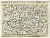
Tübingen mit dero Gegend auf 2 Stud etc.
1 : 150000 Mollova mapová sbírka Bodenehr, Gabriel Bodenehr, Gabriel
Le Flambeau de la Guerre Allumee au Rhin
Mollova mapová sbírka Delisle, Guillaume Schenk, Peter II
Hohenzollern Hechingische Forst-Carte welche Occasione derer in solchem Territorio Ao. 1733 enstandenen Unruhe
1 : 50000 Mollova mapová sbírka Freusberg, Marquard Rudolph von
Geographica Provinciarum Sveviae Descriptio =
Mollova mapová sbírka Hurter, Johann Christoph Bodenehr, Johann Georg
170. Stuttgart, uit: Topographische Uebersichtskarte des Deutschen Reiches / herausgegeben v. d. Kartogr. Abt. d. Königl. Preuß. Landesaufnahme
1 : 200000 titelvariant: Topogr. Übersichtskarte des Deutschen Reiches; Annotatie: Titel boven bladen ook: Topogr. Übersichtskarte des Deutschen Reiches; Annotatie geografische gegevens: Op elk blad twee maatstokken: 10 Kilometer = 5,5 cm; 1 geogr. Meile = 3,6 cm; Legenda onder op elk blad Königlich Preußische Landesaufnahme. Kartographische Abtheilung [S.l : Königlich Preußische Landesaufnahme, Kartographische Abtheilung]
Nordwestlicher Abhang der Schwäbischen Alp
Geologischer Atlas zur Naturgeschichte der Erde Leonhard, Carl Cäsar von E. Schweizerbart'sche Verlagsbuchhandlung
Suevia Universa :
1 : 170000 Mollova mapová sbírka Michal, Jacques de Seutter, Matthäus Seutter, Matthäus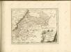
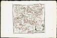
Des Herzogthums Würtemberg westsüdliche Aemter mit der freyen Reichsstadt Reutlingen : Nro. 188
Reilly, Franz Johann Joseph von
Tubingen
1 : 200000 Herder, Benjamin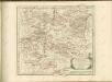

Die untere Markgrafschaft Baaden oder die Grafschaft Eberstein mit den Durlachischen Landen
1 Karte : Kupferdruck ; 18 x 24 cm Reilly F. J. J. von Reilly
Strassburg 127, uit: Special-Karte von Mittel-Europa / nach amtlichen Quellen bearbeitet von W. Liebenow
1 : 300000 titelvariant: W. Liebenow's Mittel-Europa; Annotatie: Titel boven de bladen: W. Liebenow's Mittel-Europa Johannes Wilhelm Liebenow 1822-1897 Frankfurt a. M. : Ludwig Ravenstein
Strasburg 127, uit: [W. Liebenow's Special-Karte von Mittel-Europa]
1 : 300000 titelvariant: W. Liebenow's Mittel-Europa; Annotatie: Titel boven de bladen: W. Liebenow's Mittel-Europa Johannes Wilhelm Liebenow 1822-1897 Hannover : Hermann Oppermann
March. Badensis pars, duc. septentrio Wurtenbergici pars
Bádensko (Německo)
Des Herzogthums Würtemberg westsüdliche Aemter mit der freyen Reichsstadt Reutlingen
1 Karte : Kupferdruck ; 23 x 26 cm Reilly F. J. J. von Reilly
Des Herzogthums Würtemberg nordwestliche Aemter mit der freyen Reichsstadt Weil
1 Karte : Kupferdruck ; 23 x 26 cm Reilly F. J. J. von Reilly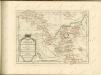

Carte topographique d'Allemagne
1 : 218000 Alsasko (Francie) Jaeger, Johann Wilhelm Abraham Facius, Johann Gottlieb chez I.W.A. Iaeger
Carte topographique d'Allemagne
1 : 218000 Alsasko (Francie) Jaeger, Johann Wilhelm Abraham I. W. A. Iaeger
Nova et accuratißima Ducatus Wurtenbergici
1 : 300000 Mollova mapová sbírka Seutter, Matthäus Seutter, Matthäus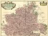
Carte tres Particuliere du Duché de Wirtemberg
1 : 240000 Mollova mapová sbírka Fer, Nicolas de Loon, Herman van L'Isle, Guillaume de
Generalkarte von Württemberg: Blatt III
1 : 1500000 Terrainzeichnung: Bach, Topograf und Hauptmann Lithografie: Rebmann und Sommer Herausgeber: K. statistisch-topografisches Büro
Generalkarte von Württemberg: Blatt I
1 : 1500000 Mit Übersichtskarte. Terrainzeichnung: Bach, Topograf und Hauptmann Lithografie: Rebmann und Sommer Herausgeber: K. statistisch-topografisches Büro
Geographica provinciarum Sueviae descriptio, 3
4 Blätter : Johann Georg Bodenehr
Carte particulìere des pays quì sont sítuéz entre la Rhein, la Saare, la Mosselle et la basse Alsace, contenant partìe du Palatinat, des Electorats de Mayence de Treves des Eveschés de Spìres et de Wormes avec les Duchés de Deuxponts et des Sìmmeren.
from Atlas françois : contenant les cartes geographiques dans lesquelles sont tres exactement remarquez les empires, monarchies, royaumes et estats de l'Europe, de l'Asie, de l'Afrique et l'Amérique : avec les tables et cartes particulieres de France, de Flandre, d'Allemagne, d'Espagne et d'Italie / par ... Hubert Iaillot, geographe ordinaire ...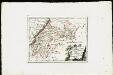
Die untere Markgrafschaft Baaden oder die Grafschaft Eberstein mit den Durlachischen Landen : Nro. 192
Reilly, Franz Johann Joseph von
Suevia universa IX. tabulis delineata, 4
1 Blatt : s.n.
![Meßtischblatt [7419] : Herrenberg, 1901](https://images-1.georeferencer.com/images/iiif/357413071744/full/,300/0/native.jpg)

