Maps of Regierungsbezirk Freiburg

Suevia universa IX. tabulis delineata, 4
1 Blatt : s.n.
D.O.M.S. Serenissimo Celsissimoque Principi ac Domino Domino Eberhardo Ludovico Duci Würtenbergiae et Thecciae Comiti Montis belgardi, Dynastae in Haydenheim etc. Sac. Caes. Mai. ac Rom. Imp. ut et Circuli Suevici General Mareschallo Campi et Generali Equitatiis etc. Domino suo Clementißimo Tabulam hanc in debitae submissionis tessoniman
1 : 315000 [S.l.] : [s.n.]
Doms Serenißimo Celsißimoq;
1 : 250000 Mollova mapová sbírka Homann, Johann Baptist Homann, Johann Baptista - dědici
D.O.M.S. Serenissimo Celsissimoque Principi ac Domino Domino Eberhardo Ludovico Duci Würtenbergiae et Thecciae Comiti Montis belgardi, Dynastae in Haydenheim etc. Sac. Caes. Mai. ac Rom. Imp. ut et Circuli Suevici General Mareschallo Campi et Generali Equitatiis etc. Domino suo Clementißimo Tabulam hanc in debitae submissionis tessoniman
1 : 315000 [S.l.] : [s.n.]

Sheet 4, uit: Stanford's large scale map of the seat of war / Stanford's Geographical Estab[lishmen]t
1 : 300000 Stanford's Geographical Establishment, Londen London : Stanford
Mappa geographica ad Historiam Nigræ Silvæ Martini Gerberti S.R.I.P. monasterii & congreg. S. Blasii. abbatis
1 Karte auf 2 Blatt : Kupferdruck ; 94 x 59 cm Gerbert; Haas; Grüninger s.n.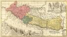
Vera totius Marchionatus Badensis
1 : 230000 Mollova mapová sbírka Valk, Gerhard Schenk, Peter I
Karte vom Schwarzwald
1 : 400000 Schnars, Carl Wilhelm ; Sachs, Friedrich Carl Winters's Universitätsbuchhandlung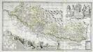
Vera totius marchionatus Badensis, et Hochbergensis
1 Karte auf 2 Blatt : Kupferdruck ; 43 x 80 cm Janssonius van Waesbergen; Pitt; Swart; Morell; Beuch excudebat Janssonio-Waesbergii Moses Pitt et Stephanus Swart
Theatrum belli ad Rhenum superior
1 : 400000 Alsasko (Francie) Homanninanis Heredes
Theatrum belli ad Rhenum superior
1 : 400000 Alsasko (Francie) Homanninanis Heredes
Geographica provinciarum Sueviae descriptio, 3
4 Blätter : Johann Georg Bodenehr
Die untere Markgrafschaft Baaden oder die Grafschaft Eberstein mit den Durlachischen Landen : Nro. 192
Reilly, Franz Johann Joseph von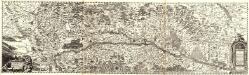
Accurata Et Novissima Landgraviatus Alsatiae Chorographia
Mollova mapová sbírka Person, Nikolaus Person, Nicolas
Département du Bas Rhin
1 : 265000 Bas-Rhin (Francie) Houdan, François d' Bureaou de l'Atlas national
Département du Bas Rhin
1 : 250000 Bas-Rhin (Francie) Chanlaire, Pierre-Grégoire P.G. Chanlaire
Militair Karte von Süd-Deutschland in 20 Sectionen
1 : 400000 9. Section Coulon, Alois von A. von Coulon
Stuttgart

Département du Bas Rhin
1 Karte : Kupferdruck ; 49 x 48 cm Houdan au bureau de l'atlas national rue de la Harpe no. 26, et au dépot du dit atlas rue de la Monnoye no. 5
Carte topographique d'Allemagne
1 : 218000 Alsasko (Francie) Jaeger, Johann Wilhelm Abraham Facius, Johann Gottlieb chez I.W.A. Iaeger
Carte topographique d'Allemagne
1 : 218000 Alsasko (Francie) Jaeger, Johann Wilhelm Abraham I. W. A. Iaeger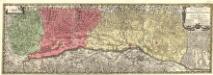
Alsatia Superior et Inferior III. Tabulis
1 : 120000 Mollova mapová sbírka Micheli du Crest, Jacques-Barthélemy Seutter, Matthäus
Landgraviatus Alsatiae Inferioris Novissima Tabula
1 : 280000 Mollova mapová sbírka Visscher, Nicolaes Jansz. Schenk, Peter II
Département du Bas Rhin
1 Karte : Kupferdruck ; 40 x 35 cm Capitaine s.n.
Carte particulìere des pays quì sont sítuéz entre la Rhein, la Saare, la Mosselle et la basse Alsace, contenant partìe du Palatinat, des Electorats de Mayence de Treves des Eveschés de Spìres et de Wormes avec les Duchés de Deuxponts et des Sìmmeren.
from Atlas françois : contenant les cartes geographiques dans lesquelles sont tres exactement remarquez les empires, monarchies, royaumes et estats de l'Europe, de l'Asie, de l'Afrique et l'Amérique : avec les tables et cartes particulieres de France, de Flandre, d'Allemagne, d'Espagne et d'Italie / par ... Hubert Iaillot, geographe ordinaire ...
Kriegs-Theatrum.
Mollova mapová sbírka Lidl, Johann Jakob Lidl, Johann Jacob
Strasburg 127, uit: [W. Liebenow's Special-Karte von Mittel-Europa]
1 : 300000 titelvariant: W. Liebenow's Mittel-Europa; Annotatie: Titel boven de bladen: W. Liebenow's Mittel-Europa Johannes Wilhelm Liebenow 1822-1897 Hannover : Hermann Oppermann
Strassburg 127, uit: Special-Karte von Mittel-Europa / nach amtlichen Quellen bearbeitet von W. Liebenow
1 : 300000 titelvariant: W. Liebenow's Mittel-Europa; Annotatie: Titel boven de bladen: W. Liebenow's Mittel-Europa Johannes Wilhelm Liebenow 1822-1897 Frankfurt a. M. : Ludwig Ravenstein


